Timeline 60BC – 138AD
This timeline is focussed on the British Celtic culture and those cultures which had influence on the British Celts. It Read more
Cartimandua
Yorkshire, and much of northern Britain was also ruled by a queen, the most powerful ruler in Britain in fact. Read more
Caratacus
Caratacus was highly influenced by the Druids, and both he and his brother Togodumnus were among the leading lights of Read more
Cerialis Petillius
Quintus Petillius Cerialis Caesius Rufus was the son-in-law of Vespasian Cerialis and became Governor of Britain in AD.71; his instructions Read more
Julius Caesar
Ask anyone to name a famous Roman character, and the name of Julius Caesar is sure to be the most Read more
Vespasian
Born in the year 9 at Reate, north of Rome, Vespasian was the son of a tax collector, Flavius Sabinus Read more
Augustus
Suetonius wrote of him: He was very handsome and most graceful at all stages of his life, although he cared Read more
Claudius
Tiberius Claudius Nero Germanicus was born Lugunum in 10 BC, the youngest son of Nero Drusus, brother of Tiberius. He Read more
Celtic Gods
Many Celtic deities seem to have been associated with aspects of nature and worshipped in sacred groves. Some appear in Read more
Baal
Baal, Baalim BAAL WORSHIP But the religious customs of the Covenant people became corrupted with the religion of the Phoenician Read more

Prehistoric Yorkshire is a landscape rich with history, revealed through various archaeological finds that offer a glimpse into the ancient past. The oldest evidence of human activity in this region dates back to around 125,000 years ago, but it is the later periods, particularly the Iron Age, that have yielded significant discoveries related to ploughing and farming. For instance, aerial surveys during dry summers have uncovered Iron Age farmsteads near the Yorkshire Wolds, visible as crop marks on the ground. These marks indicate where ancient farmers once dug ditches and erected structures, with the differences in soil moisture affecting crop growth and revealing the hidden outlines of the past.
Bronze Age Agriculture
During the Bronze Age, a period defined by the use of metal alloys including bronze, agriculture saw significant advancements, including the development and use of various ploughing techniques and tools. The ploughs of this era were primarily wooden, often pulled by oxen, and were essential for turning the soil to prepare it for sowing seeds. The design of these ploughs was simple yet effective, consisting of a plough-beam with a draught-hole for attachment to the yoke, and a large mortise through which the ploughshare and stilt would be wedged. This design is evidenced by archaeological finds such as the plough-beam discovered near Lochmaben in Dumfriesshire, which, although badly warped, is complete and indicative of the type of ploughing implements used in Britain during the transition from the Late Bronze Age to the Early Iron Age.
The plough-heads found in this period were often made from a single piece of wood, with a groove cut down the middle of its upper surface to fit a ridge or tongue projecting from the underside of the plough-share. This is exemplified by the find beneath a crannog in Milton Loch, Kirkcudbrightshire, which dates back to the second century A.D. but reflects the style of earlier Bronze Age ploughs. These early ploughs did not feature coulters or mould-boards, which are common in modern ploughs, suggesting that they were designed for the dry and warm climatic conditions of north-western Europe during the Bronze Age. The absence of these components indicates that the ploughs were used to pulverize and stir the soil, a method necessary to minimize water evaporation in such climates.
Cross-ploughing, a technique where the field is ploughed in a criss-cross pattern, was traditionally associated with this kind of tillage. It helped to further break down the soil and ensure that it was well-aerated and ready for planting. The use of cross-ploughing also points to a sophisticated understanding of agricultural practices and soil management by Bronze Age farmers.
In addition to wooden ploughs, stone tools were also an integral part of the Bronze Age farmer’s toolkit. Flint tools, for example, were used for various agricultural purposes, including the preparation of fields for ploughing. These flints were often thermally fractured and then struck to create sharp edges for cutting or scraping, as seen in pieces found from the Later Bronze Age.
The Bronze Age was a time of considerable innovation in agriculture, with the development of ploughing techniques and tools that laid the groundwork for future advancements. The tools and methods used were adapted to the environmental conditions of the time, demonstrating the ingenuity and adaptability of our ancestors. The legacy of their innovation is still evident in the agricultural practices and tools we use today, albeit in a more advanced form. The study of these ancient techniques not only provides insight into the past but also offers a perspective on the evolution of human ingenuity in harmony with the natural world.
In the Bronze Age, a variety of tools beyond the plough were essential for agricultural practices. The development of bronze, a durable alloy of copper and tin, led to the creation of stronger and more reliable tools that revolutionized farming. Axes made of bronze allowed for more efficient clearing of forests and underbrush, making way for new agricultural land. These axes were not only sharper but also more durable than their stone predecessors, enabling them to withstand the rigours of heavy use.
Sickles, which featured curved blades, were used for harvesting crops. The bronze sickles retained their sharpness over many uses, allowing for quicker and more effective harvesting. This efficiency was crucial for ensuring that crops could be collected swiftly before any adverse weather could damage them.
In addition to axes and sickles, other hand tools such as chisels, hammers, and adzes were employed for various tasks. Chisels and hammers would have been used for woodwork and construction, aiding in the building of structures such as storage facilities for harvested grains. Adzes, which are similar to axes but with a perpendicular blade, were likely used for smoothing and carving wood, important for creating yokes for oxen and handles for other tools.
Bronze Age farmers also utilized digging sticks, which were simple but effective tools for breaking up the earth. These sticks could be made of wood or bone and were sometimes tipped with a bronze point to increase their durability and effectiveness. The digging stick was a precursor to the spade and was used for planting seeds and small-scale cultivation.
Irrigation tools, although not as commonly preserved in the archaeological record, were also a critical component of Bronze Age agriculture. Canals and ditches would have been constructed using shovels and hoes made from wood and bronze. These irrigation systems allowed for the expansion of agriculture into areas that were not naturally well-watered, thereby increasing the amount of land that could be cultivated.
The wheel and ox-drawn cart were significant innovations of the Bronze Age that greatly enhanced the efficiency of farming. The ability to transport goods and materials over longer distances with less effort was transformative. Carts would have been used to move heavy loads, such as stones for construction or harvested crops, to storage locations.
Bronze Age agriculture was characterized by a balance between innovation and tradition. While new tools and techniques were developed, many of the fundamental practices remained rooted in the knowledge passed down through generations. The tools of the Bronze Age reflect a period of transition and growth in agricultural technology, setting the stage for further advancements in the Iron Age and beyond. The ingenuity of Bronze Age peoples in developing these tools demonstrates a profound understanding of their environment and a commitment to improving their agricultural output. The legacy of their craftsmanship and innovation continues to influence modern agricultural practices, reminding us of the enduring impact of this pivotal era in human history.
Iron Age Agriculture
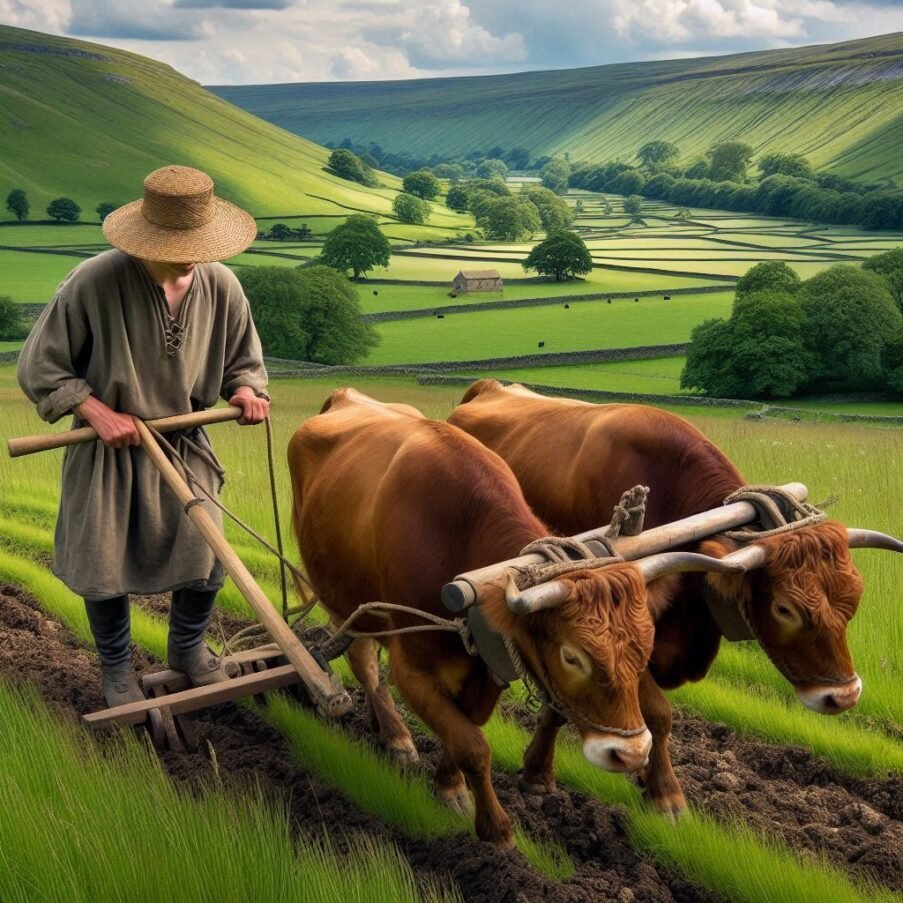
During the Iron Age, a significant advancement in agricultural practices was observed, particularly in the realm of ploughing techniques and tools. The primary instrument used was the Ard, also known as a scratch plough, which was a simple and robust tool designed to break the soil rather than turn it over as modern ploughs do. This tool typically featured a pointed wooden tip, sometimes reinforced with an iron blade, which allowed for the creation of furrows suitable for sowing seeds. The ard’s design was conducive to the heavy clay soils prevalent during that era, making it easier to cut through the soil compared to its all-wooden Bronze Age predecessors.
The process of ploughing with an ard required multiple passes over the same field in different directions, a technique known as cross-ploughing, to effectively break up the soil and prepare it for planting. This method was labor-intensive but necessary due to the ard’s inability to invert the soil layers, which is beneficial for burying weeds and aerating the soil. The cross-ploughing pattern is often visible in aerial photographs of Iron Age settlements, indicating the widespread adoption of this technique.
In addition to the ard, other tools such as hoes and spades were likely used for more detailed work and to manage smaller plots of land. The use of iron in these tools marked a significant improvement over previous stone implements, allowing for more efficient cultivation and management of agricultural lands. The introduction of iron also facilitated the development of more durable and effective ploughshares, which could penetrate deeper into the soil, thus expanding the range of land that could be cultivated.
The Iron Age also saw the refinement of ploughing techniques, with evidence suggesting that farmers followed new methods that differed from earlier practices. These advancements likely contributed to increased agricultural productivity, which supported larger populations and led to the growth of more complex societies.
The ploughing techniques and tools of the Iron Age represent a pivotal moment in agricultural history, reflecting the ingenuity and adaptability of our ancestors. The legacy of these early farming practices can still be discerned in the landscapes of today and continues to inform our understanding of past agricultural societies.
Iron Age farming practices were a testament to the ingenuity and adaptability of our ancestors, reflecting a in-depth understanding of their environment and the resources available to them. The period saw various crops being cultivated, with six-row barley being the predominant crop throughout Iron Age Scotland, for instance. This was often accompanied by oats and occasionally emmer wheat, as well as spelt, which were grown in smaller quantities. The cultivation of flax was also noted, which could have been used for food, oil, or fibres, showcasing the versatility of crops during this era.
Livestock played a crucial role in Iron Age agriculture, with evidence suggesting that farmers kept geese, goats, and pigs, alongside large herds of cows and flocks of sheep. This not only provided a diverse diet but also essential materials such as wool and leather, which were crucial for clothing and other goods. The integration of crop and livestock farming would have been essential for sustaining the Iron Age communities, allowing for a self-sufficient lifestyle.
The farming techniques of the time were sophisticated for the period. The ard plough, a significant innovation of the Iron Age, was widely used to prepare the fields for sowing. This tool, while simple in design, was effective in breaking the soil and creating furrows for planting seeds. The ard’s efficiency was further enhanced by the introduction of iron tips, which allowed for deeper penetration into the soil and improved durability.
The environmental impact of these farming practices was also significant. Archaeobotanical and isotopic evidence suggests that the agricultural practices of the Iron Age had considerable socio-economic and environmental implications, influencing community organization and relationships with the landscape. The use of functional weed ecology to reconstruct crop husbandry practices provides insights into the cereal production systems of the time and their evolution from the Iron Age to the Roman period.
In addition to crop cultivation, the Iron Age diet was supplemented by gathered and hunted food. Cooking methods included hearths and cooking pits, and in some areas of Scotland, there is evidence for the continued use of hot stone cooking technology. This method involved heating stones in a fire and then using them to cook food, a technique that likely dates back to earlier periods.
The archaeological record also provides insights into the storage and preservation of food. Storage pits, often lined and located near roundhouses, were used to store grains and other produce. These pits sometimes contained large amounts of burnt grain, indicating that fire might have been used as a method of preservation or that accidents occurred during processing.
The Iron Age was a period of transition and innovation in farming practices, which laid the foundations for future agricultural advancements. The techniques and tools developed during this time were crucial in supporting larger populations and the growth of more complex societies. The legacy of Iron Age farming is still evident in the landscape today and continues to inform our understanding of past agricultural societies. The resilience and resourcefulness of Iron Age communities are reflected in the enduring evidence of their farming practices, which have been pieced together through various archaeological findings and continue to fascinate researchers and historians alike.
The Iron Age, a period marked by the widespread use of iron for tools and weapons, also saw significant developments in agriculture. Typical crops cultivated during this era included staples such as wheat, oats, and barley. These grains were fundamental to the Iron Age diet, providing a base for bread and porridge, which were common foods of the time. Wheat, particularly spelt and emmer varieties, was highly valued for its use in bread-making, a staple food that could be stored and traded. Barley, with its resilience to various climates, was a versatile crop used not only for food but also for brewing beer, an important beverage in Iron Age society.
The introduction of rye, a hardy grain well-suited to the cooler climates of Northern Europe, represented an adaptation to the changing environmental conditions and dietary needs of the population. Millet, though less common, was also grown and likely used as a supplementary grain or for animal fodder. The cultivation of these crops was a labor-intensive process, requiring the clearing of land, tilling of soil with iron-tipped ards, and careful management of harvests to ensure food security throughout the year.
Agricultural practices of the Iron Age were closely tied to the seasons and the environment. Farmers had to understand the rhythms of nature to ensure successful planting and harvesting. The use of iron tools, such as sickles and ploughs, made the work more efficient, allowing for larger areas to be farmed and ultimately supporting a growing population. Crop rotation and fallowing were likely practised to maintain soil fertility, although the specifics of these techniques are not fully understood.
In addition to grains, Iron Age farmers also cultivated flax, which served multiple purposes. The fibres were used for making linen, while the seeds could be consumed or pressed for oil. This versatility made flax an important crop, contributing to both the dietary and material needs of Iron Age communities.
The archaeological record, including seeds found at settlement sites and impressions of grains in pottery, provides evidence of these agricultural practices. Moreover, the remains of storage pits and granaries indicate that Iron Age people had developed methods for preserving and storing their harvests, ensuring a supply of food throughout the year and in times of scarcity.
The typical crops of the Iron Age reflect the agrarian foundation of society during this period. The cultivation and processing of these crops were integral to the daily life and economy of Iron Age communities, influencing social structures, trade, and even religious practices. As such, the study of these crops offers valuable insights into the lives of our ancestors during this pivotal period in history.
Roman Agriculture
During the Roman period, ploughing techniques and tools were pivotal to agricultural practices, significantly contributing to the efficiency of farming and the expansion of Roman territories. The primary plough used in Roman Britain was the ‘Ard’ or ‘Scratch Plough,’ which was a simple and light implement designed for cutting the soil in preparation for sowing rather than turning it over. This plough typically consisted of a wooden frame with a pointed iron share that cut the soil and a coulter that made a vertical cut in the ground ahead of the share, aiding in the plough’s penetration. The Ard did not have a mouldboard, which is used in modern ploughs to turn the soil. Instead, it scratched the surface, hence its name.
The plough beam, often made from elm, was shaped into a curved form known as a ‘buris,’ and to this were attached various parts including a pole (‘temo’), two ears (‘aures’), and a share-beam (‘dentalia’) with a double back. The length of the pole was typically around 8 feet, allowing for effective leverage and control. The design of these ploughs was such that they could be easily assembled and repaired with locally available materials, which was essential for the widespread adoption of this agricultural tool across the diverse regions of the Roman Empire.
Evidence of these ploughs has been found in various archaeological sites across Britain and Germany, with some of the most informative finds being the surviving parts of Romano-British ploughs, such as shares and coulters. These finds, along with literary sources like Vergil’s “Georgics” and Pliny the Elder’s writings, provide a detailed understanding of the construction and use of Roman ploughs. Pliny’s work, in particular, offers an intricate description of the types of shares used and occasionally sheds light on other aspects of Roman agricultural tools.
The efficiency of the Roman plough was further enhanced by the use of animal power. Oxen were commonly employed to pull the ploughs, as they were well-suited to the slow and steady pace required for ploughing fields. The yoke used to harness the oxen was attached to the plough through a draught-hole in the beam, allowing for the transfer of the animals’ strength to the task of breaking the soil. This method of ploughing would have been labour-intensive but effective in the cultivation of the types of crops grown during the period, such as wheat, barley, and millet.
The agricultural practices of the Romans, including their ploughing techniques, were not only a testament to their engineering skills but also an indication of their understanding of land management and crop production. The spread of these practices throughout the Roman Empire played a significant role in the development of agriculture in Europe, laying the foundations for future advancements in farming technology. The legacy of Roman agricultural tools and techniques continues to be a subject of study and admiration, reflecting the ingenuity and adaptability of ancient societies in their quest to harness the natural world for sustenance and growth.
In addition to the ‘Ard’ or ‘Scratch Plough,’ Roman agriculture utilized various tools that were essential for the diverse farming tasks required to sustain the empire’s vast population. The ‘Pala’ or shovel was a fundamental tool, used for moving soil and manure, while the ‘Ligo’ or hoe, with its curved blade, was employed for weeding and breaking up the soil. The ‘Rastrum’ or rake, with its iron teeth, was used to smooth the soil after ploughing, and the ‘Sarculum’ or hand hoe, allowed for more precise work around plants.
The ‘Falx’ or sickle was a critical implement for harvesting crops, especially grains. Its curved blade enabled efficient cutting of stems close to the ground. For larger scale operations, the ‘Vallus’ or reaping machine, which was pushed by oxen, could be used to cut down crops more quickly. The ‘Fuscina’ or pitchfork was used for tossing and turning hay, a necessary step in ensuring even drying and preventing rot.
Irrigation was another area where the Romans showed their ingenuity. The ‘Forma’ or water channelling tool, often made of wood or stone, was used to direct water to the fields. The ‘Tympanum’ or water wheel, sometimes powered by animals, lifted water from lower to higher ground when natural gravity flow was insufficient.
The ‘Tribulum’ or threshing sled, often pulled by animals over harvested grain, separated the grain from the chaff. The ‘Pecten’ or comb was then used to clean the collected grain further. The ‘Modius’ or grain measure ensured consistent measurement for trade or storage purposes.
For vineyards, specialized tools such as the ‘Falcina’ or pruning knife and the ‘Dolabra’ or vine-digger were used for pruning and cultivating grapevines. The ‘Culeus’ or wine sack was essential for storing and transporting wine, one of the empire’s most valuable commodities.
The Romans also employed various containers and storage solutions, such as the ‘Amphora’ for liquids and the ‘Horreum’ or granary for bulk storage of grains. The ‘Cuppa’ or basket was used for carrying and storing smaller quantities of produce.
The ‘Stiva’ or plough handle and the ‘Burdones’ or yoke were parts of the plough system that allowed for better control and efficiency in using animal labor. The ‘Capistrum’ or halter and the ‘Lorum’ or strap were used in managing and directing the animals during ploughing and other tasks.
These tools, crafted from materials like iron, wood, and bronze, were a testament to Roman craftsmanship and engineering. They were designed to be durable, efficient, and suited to the tasks at hand, reflecting a deep understanding of both the materials they had available and the agricultural practices they needed to support. The legacy of these tools is evident in the continued use of many similar implements in agriculture today, albeit with modern materials and enhancements. The Roman approach to agriculture was a blend of practicality and innovation, ensuring that their farming practices remained effective and sustainable over centuries.
In the fertile expanses of the Roman Empire, a diverse array of crops was cultivated to sustain its vast population and fuel its economic activities. The cornerstone of Roman agriculture was the trio of cereals, olives, and grapes, which formed the basis of the Mediterranean diet and were integral to the empire’s trade and commerce. Grains such as wheat, barley, oats, rye, and millet were staples, with wheat being particularly prominent due to its use in making bread, a daily sustenance for Romans. Durum wheat, introduced around 450 BC, became favoured in urban areas for its suitability in bread making and its adaptability to the Mediterranean climate.
Legumes also played a significant role in the Roman diet and agricultural practices. Crops like beans, peas, and lentils were valued both for their nutritional content and their ability to enrich the soil through nitrogen fixation. These legumes were often rotated with cereal crops to maintain soil fertility and prevent depletion of essential nutrients.
The Mediterranean climate was ideal for the cultivation of olives, which were a vital source of food, oil, and trade goods. Olive oil was used not only in cooking but also in lamps, medicines, and religious ceremonies, making it a commodity of high economic and cultural importance. Similarly, viticulture was highly developed in Roman times, with grapes being used for wine, an essential part of Roman dining and social rituals.
Fruits and nuts were also abundant in Roman agriculture, with orchards yielding figs, pears, apples, peaches, cherries, plums, and walnuts. The Romans were skilled in horticultural techniques such as grafting, which allowed them to improve crop yields and varieties. Apples, for instance, were spread throughout the empire, and their cultivation was enhanced through these methods.
Vegetables and herbs were cultivated in gardens for culinary and medicinal purposes. The Roman diet included a variety of greens and vegetables like mustard, coriander, artichoke, rocket, leeks, mint, celery, capers, basil, rue, thyme, chives, parsnip, and radish. These gardens were often located near the household for easy access and were an essential part of daily life.
The Romans also understood the importance of crop rotation and soil management. They followed wheat with crops like rye, barley, or oats, and sometimes planted beans or peas, which could be ploughed under as green manure to enrich the soil. Alfalfa was well established in Italy before the beginning of our era and was brought from Greece, having originated from Asia. This practice of rotating crops and allowing land to lie fallow helped maintain soil health and productivity.
In addition to these crops, fodder for animals was necessary to support the empire’s transportation and agricultural needs. Crops like clover, vetch, and alfalfa were grown to feed the oxen and horses that were essential for ploughing fields and transporting goods.
The Roman agricultural system was a complex and well-organized enterprise, with large estates known as latifundia playing a significant role in production. These estates often utilized slave labor and were capable of producing large surpluses for trade. The growth of the urban population, particularly in Rome, necessitated the development of commercial markets and long-distance trade in agricultural products to ensure a steady food supply.
The agricultural knowledge and practices of the Romans were documented by agronomists such as Cato the Elder, Columella, Varro, and Palladius. Their writings provide valuable insights into the methods and tools used in Roman farming, as well as the types of crops grown. The agricultural treatise Rusticatio, attributed to Mago the Carthaginian, is believed to have been an early source of agricultural knowledge in the Near East and Classical world, although the original text is now lost.
Roman agriculture was not merely a means of sustenance but was also idealized as a way of life. Cicero, the Roman statesman and philosopher, considered farming the best of all Roman occupations, embodying the virtues of economy, industry, and justice. The Roman farmer’s connection to the land and his crops was seen as a source of moral and physical well-being, reflecting the agrarian roots of Roman society and its enduring legacy in the history of agriculture.
Dark Age Agriculture
During the Dark Ages, a period that broadly spans from the fall of the Roman Empire to the beginning of the Renaissance, agriculture was a fundamental aspect of life, and ploughing techniques were crucial for food production. The primary tool used for ploughing during this era was the ard, also known as the scratch plough. This was a simple and lightweight implement, typically made of wood, which was capable of scratching the surface of the soil to prepare it for sowing seeds rather than turning it over. The ard was well-suited to the lighter, sandier soils of the Mediterranean regions but less effective on the heavier clay soils of Northern Europe.
The innovation of the heavy plough in the early medieval period marked a significant advancement in agricultural technology. This plough featured several key components that improved its efficiency: an Asymmetric ploughshare that cut the soil horizontally, a coulter that sliced vertically, and a mouldboard that turned the soil. The heavy plough allowed for deeper tillage, better weed control, and more effective incorporation of organic materials into the soil, which was particularly beneficial for the fertile but difficult-to-work clay soils of Northern Europe. The use of the heavy plough is often associated with the agricultural revolution in medieval Europe, as it enabled the expansion of arable land and contributed to increased population density and urbanization.
In addition to the ploughs, other tools such as forks were employed for preparing the ground for seeding and covering, especially in smaller areas where a plough or harrow would not be practical. These tools were rudimentary compared to modern standards but were essential for the agricultural practices of the time. The evolution of ploughs and the introduction of new techniques played a pivotal role in shaping the agricultural landscape of the Middle Ages, laying the groundwork for future developments in farming and food production. The heavy plough, in particular, stands out as a transformative innovation that had lasting impacts on European agriculture and society.
The heavy plough, a remarkable innovation of the early Middle Ages, was a transformative agricultural tool that significantly influenced the economic development of Europe between AD 900 and 1300. Its introduction marked a departure from the ard, or scratch plough, which was suitable for lighter soils but less effective on the heavy, clay-rich soils prevalent in Northern Europe. The heavy plough’s design featured a robust, asymmetric ploughshare that cut horizontally into the soil, a sharp coulter for vertical slicing, and a curved mouldboard that facilitated the turning over of soil. This allowed for deeper tillage, improved weed control, and better incorporation of organic matter, leading to enhanced soil fertility and higher crop yields.
The heavy plough’s ability to work the dense clay soils transformed previously uncultivable land into productive farmland, spurring an agricultural revolution. This revolution was characterized by increased efficiency and productivity, which supported larger populations and contributed to the growth of urban centres. The heavy plough also necessitated the use of stronger, more powerful draft animals such as oxen or horses, which, in turn, led to innovations in harnessing and a shift towards more systematic crop rotation practices.
Lynn White Jr., in his influential work, posited that the heavy plough was the primary driver for the economic and demographic boom around AD 1000. His thesis highlighted the plough’s role in enabling extensive cultivation of the Northern and Eastern European wilderness, which had been previously limited by the inadequacy of the ard. The heavy plough not only turned the soil and buried weeds but also brought nutrient-rich subsoil to the surface, further enriching the arable land.
The impact of the heavy plough extended beyond agriculture, indirectly fostering a need for peasant collaboration, particularly in the management of draft animals and the maintenance of fields. This collaboration may have laid the foundations for the later feudal systems and the communal management of land, which were characteristic of the medieval period. The introduction of the heavy plough is also associated with the transition from the infield-outfield farming system to the open-field system, which allowed for more effective land use and crop rotation.
Despite initial scepticism, recent research has supported White’s assertions, showing a strong correlation between the adoption of the heavy plough and increases in population density and urbanization. This correlation is evident when examining the regional localities in Europe with fertile clay soil and their subsequent economic and demographic growth. The heavy plough’s influence on the distribution of wealth and the development of cities in medieval Northern Europe is now well-documented, underscoring its role as a pivotal technological advancement of the time.
In summary, the heavy plough was not just an agricultural implement but a catalyst for social and economic change. Its development and widespread adoption were instrumental in shaping the medieval landscape, driving agricultural productivity, and laying the groundwork for the modernization of farming practices. The legacy of the heavy plough is still evident today in the continued use of its basic principles in modern ploughing equipment.
The heavy plough’s introduction during the early Middle Ages had a profound impact on trade and commerce in Europe. By enabling the cultivation of the heavy, clay-rich soils of Northern Europe, it significantly increased agricultural productivity and yields. This agricultural surplus was a key factor in the growth of trade, as it allowed communities to produce more food than they needed for subsistence, leading to the emergence of local and regional markets where surplus produce could be exchanged or sold.
The enhanced productivity also led to a greater specialization of labour. As farming became more efficient, fewer people were needed to work the land, which allowed more individuals to pursue other trades and crafts. This diversification of labour contributed to the economic complexity and the development of a more robust market economy. Artisans, craftsmen, and merchants became more numerous, creating a demand for trade networks and marketplaces.
Moreover, the heavy plough’s efficiency in turning over the fertile clay soils led to the establishment of larger estates and manorial systems, which were better suited to the new ploughing technology. These estates produced a variety of crops and goods, further stimulating trade as they sought to sell their surplus in distant markets. The need to transport these goods over long distances spurred improvements in infrastructure, such as roads and bridges, facilitating trade and commerce.
The prosperity brought about by the heavy plough also led to the growth of cities, which became centres of trade and commerce. These urban centres attracted merchants from various regions, who brought with them a variety of goods, contributing to the cultural and economic exchange. The cities provided a stable environment for trade, with established rules and protections for merchants, which encouraged more people to engage in commercial activities.
Furthermore, the heavy plough’s impact on agriculture had international trade implications. The increased food production in Northern Europe made it a breadbasket region, and its surplus grains were traded across the continent and even beyond. This trade in agricultural products was complemented by the exchange of other goods, such as textiles, spices, and metals, which were often traded for grain. The heavy plough thus played a role in the broader trade networks that connected Europe internally and with the rest of the world.
The economic growth fuelled by the heavy plough also led to the development of financial institutions and instruments. As trade expanded, so did the need for credit and investment. This need gave rise to the establishment of banks, the use of bills of exchange, and other financial innovations that facilitated commerce. The heavy plough indirectly contributed to the sophistication of the medieval economy by necessitating these financial developments.
In summary, the heavy plough was not just an agricultural implement but a catalyst for widespread economic change. Its introduction and adoption led to increased agricultural productivity, which in turn stimulated trade and commerce, contributed to the growth of cities, and led to the development of financial institutions. The heavy plough’s influence on the medieval economy was profound, setting the stage for the commercial revolution that would define the late medieval period.
The heavy plough’s introduction during the early Middle Ages was a significant technological advancement that had far-reaching effects on the social structures of medieval Europe. By enabling the efficient cultivation of heavy, clay-rich soils, it facilitated a dramatic increase in agricultural productivity. This surplus in production led to a shift in the rural economy, which had profound implications for the social hierarchy and organization of medieval societies.
One of the most notable impacts was the transformation of the manorial system. The heavy plough required a team of oxen or horses to operate, which was beyond the means of most small-scale peasant farmers. This led to the consolidation of land under the control of the nobility and the church, who had the resources to invest in such technology. As a result, the feudal system became more pronounced, with peasants working on the lands of the lords in exchange for protection and a portion of the crops.
The increased productivity also allowed for a greater specialization of labour. With more food available, not everyone needed to be involved in agriculture. This led to the growth of other professions and trades, contributing to the development of a more diverse and complex society. Artisans, merchants, and craftsmen began to form guilds, which played a significant role in urban development and the economy.
Moreover, the surplus of food and the rise of trade associated with the heavy plough’s adoption contributed to the growth of towns and cities. These urban centres became hubs of economic activity, fostering a burgeoning middle class of merchants and traders. This urbanization process helped to break down the rigid social structures of the feudal countryside, offering more social mobility and opportunities for wealth accumulation outside the traditional feudal hierarchy.
The heavy plough also indirectly influenced the social landscape by promoting the use of more systematic crop rotation practices and the establishment of the open-field system. This system required cooperation among peasants, leading to the formation of village communities with shared interests and collective responsibilities. These communities held common rights to the land and had to work together to manage the fields, which fostered a sense of solidarity and interdependence.
Furthermore, the heavy plough’s impact extended to gender roles within society. The physical strength required to operate the heavy plough meant that ploughing became predominantly a male occupation. This reinforced the division of labour along gender lines, with women often taking on roles that were less physically demanding but equally crucial to the agricultural economy, such as dairy production, poultry keeping, and gardening.
The heavy plough also had implications for the social status of peasants. Those who owned or had access to a heavy plough and the necessary draft animals could cultivate more land and produce more surplus, which could elevate their status within the peasant community. This created a hierarchy among peasants, with wealthier peasants often having more influence and power in local affairs.
In addition, the heavy plough’s introduction is associated with changes in land tenure and property rights. As the demand for arable land increased, so did the value of land, leading to more formalized systems of land ownership and inheritance. This had significant social implications, as it solidified the wealth and power of the landowning classes while also creating a more structured and legally defined system of land tenure for peasants.
The heavy plough’s influence on social structures was not limited to rural areas. The increased agricultural productivity supported larger populations, which in turn required more goods and services. This demand led to the expansion of trade networks and the rise of merchant classes, who often wielded considerable economic and sometimes political power. The prosperity of these merchants contributed to the development of more complex social hierarchies within urban settings.
In summary, the heavy plough was a catalyst for change in medieval European society. Its adoption led to increased agricultural productivity, which had a domino effect on social structures, contributing to the development of the feudal system, the rise of towns and cities, the growth of a middle class, and the evolution of gender roles and land tenure systems. The heavy plough’s impact on social structures was profound, shaping the course of medieval European history and laying the groundwork for the social transformations that would follow in the centuries to come.
The heavy plough’s introduction in medieval Europe had a significant impact on women’s roles within society. The plough’s efficiency in cultivating heavy soils led to increased agricultural productivity, which, in turn, influenced the division of labour and social structures. As the heavy plough required considerable strength and the use of draft animals, it became predominantly a male-dominated activity. This shift reinforced gender roles, with men taking on the primary responsibility for ploughing and fieldwork, while women’s roles became more focused on domestic duties and other agricultural tasks that did not require the heavy plough, such as dairy production, poultry keeping, and gardening.
The specialization of labour brought about by the heavy plough also meant that women’s contributions to agriculture, though still vital, became less visible in the public sphere. Women continued to play a crucial role in the rural economy, but their work was often undervalued and overlooked in historical records. The heavy plough indirectly contributed to a societal perception that associated men with the primary productive labour of ploughing, while women’s labour was relegated to the background.
Furthermore, the heavy plough’s impact extended to the social and legal status of women. In many cases, the consolidation of land under the manorial system and the increased value of arable land led to changes in inheritance laws and property rights. These changes often disadvantaged women, limiting their ability to own land or inherit property in their own right. As a result, women’s economic independence and social status were further diminished.
The introduction of the heavy plough also had implications for the organization of rural communities. The need for collaboration in managing the heavy plough and the draft animals required for its operation led to the formation of more cohesive village communities. Within these communities, women’s roles often centred around collective tasks and responsibilities, such as managing common resources, which were essential for the community’s survival but did not directly involve ploughing.
In the broader context of medieval society, the heavy plough’s influence on women’s roles can also be seen in the rise of urban centres and the development of trade. As men became more involved in trade and commerce, women’s roles in the urban economy diversified. Some women engaged in trades and crafts, often within the constraints of guild systems that were typically dominated by men. However, the opportunities for women to participate in the market economy were limited, and their work was often restricted to certain professions deemed suitable for their gender.
The heavy plough’s impact on women’s roles was complex and multifaceted. While it contributed to the reinforcement of traditional gender roles in agricultural societies, it also created new opportunities and challenges for women. The legacy of the heavy plough and its influence on gender roles continued to shape societal norms and expectations long after the medieval period, affecting women’s participation in the workforce and their social status for centuries to come.
In medieval agriculture, women played a crucial role that complemented the tasks performed by men. Their work was diverse and essential to the functioning of both the household and the broader agricultural economy. Women were actively involved in the process of planting and harvesting crops, such as peas and beans, which were staples of the medieval diet. They took part in weeding, a labour-intensive task that was vital for maintaining crop health and ensuring good yields. Threshing and winnowing were also part of their responsibilities; these processes separated the grain from the chaff and were critical steps in preparing the harvest for consumption or sale.
The role of women
Women’s work extended beyond the fields into the realm of animal husbandry. They were often responsible for milking cows and processing the milk into butter and cheese, products that were important for both sustenance and trade. Poultry raising was another area where women’s expertise was invaluable, as they managed the care and breeding of chickens, ducks, and geese, which provided eggs and meat for the family table.
In addition to these agricultural tasks, women were engaged in various stages of textile production—a key industry in the medieval economy. They spun wool and flax into yarn, a skill that required patience and dexterity. Weaving cloth was another common task, as textiles were required for clothing, bedding, and other household uses. Women’s work in textile production was not only a domestic chore but also a valuable economic activity, as the textiles could be sold or bartered.
The household itself was a domain where women’s labour was indispensable. They were expected to run the household efficiently, which included baking bread, brewing ale, and preserving food for the winter months. These tasks required a in-depth knowledge of food preparation and storage techniques, which were passed down from generation to generation.
Moreover, women’s work in medieval agriculture was not limited to daylight hours. They often had to manage their tasks alongside child-rearing responsibilities. This meant that their workday extended into the night, attending to the needs of their families and ensuring that the household ran smoothly.
The contribution of women to medieval agriculture was multifaceted and vital. Their labour ensured the survival and prosperity of their families and communities. Despite the physical demands and the often-overlooked nature of their work, women’s roles in medieval agriculture were central to the economic and social fabric of the time. The legacy of their hard work and expertise continues to be recognized as an integral part of the history of agriculture and rural life.
Medieval Agriculture
During the Medieval period, a variety of ploughing techniques and tools were employed to cultivate the land, which were crucial for the agrarian-based economy of the time. The heavy plough, also known as the mouldboard plough, was a significant innovation that allowed for the turning of the dense, heavy soils of Northern Europe. This plough featured a curved metal plate that cut into the soil and flipped it over, creating the furrow. The introduction of this plough was a pivotal moment in agricultural history, as it enabled the expansion of farming into areas with heavier soils that were previously difficult to cultivate.
In addition to the heavy plough, the harrow was another essential tool used post-ploughing to break up and smooth the soil, ensuring that the seeds were adequately covered. The harrow consisted of a wooden frame with spikes or nails, which could be dragged over the ploughed field to even out the soil. The use of oxen to pull these tools was common, as they provided the necessary strength to operate the heavy equipment.
The axe was also a fundamental tool in the Medieval period, not only for woodcutting and construction but also for clearing land for agriculture. The flail, a tool comprising two pieces of wood connected by a leather strap, was used for threshing, separating the grain from the husks after harvest. This tool highlights the manual nature of agricultural work during this era, where much of the processing of crops was done by hand.
Medieval farmers also practised crop rotation to maintain soil fertility and reduce the risk of disease and pest infestation. This technique involved alternating the types of crops grown in a field from year to year. Natural fertilizers such as manure, lime, chalk, and marl were used to enrich the soil and improve crop yields.
The advancements in ploughing tools and techniques during the Medieval period had a profound impact on the development of European agriculture, leading to increased productivity and the ability to support a growing population. These innovations laid the groundwork for future agricultural developments and were a testament to the ingenuity of Medieval farmers.
In addition to the previously mentioned heavy plough and harrow, Medieval farming involved a range of other tools that were essential for various agricultural tasks. The hoe, a simple yet versatile tool, was used for weeding and breaking up the soil to prepare for planting and for earthing up crops. Rakes, with their long wooden teeth, were employed to gather loose hay and grain, and to smooth out the soil after ploughing and harrowing.
Scythes, with their long, curved blades, were crucial during the harvest season to cut down cereal crops and hay. Sickles, which are smaller than scythes, were also used for harvesting, particularly for cutting grain stalks at the base. The fork, similar to the ones used today, was another important tool, used for pitching hay and for manure handling, which was vital for maintaining soil fertility.
Water management tools were also significant, as irrigation and drainage were important for crop success. Shovels and spades were used for digging irrigation channels and for general digging and moving of soil. Carts and wheelbarrows facilitated the transportation of harvested crops, manure, and other materials across the farm.
The winnowing basket was another essential tool, used to separate grain from chaff after threshing. This process was done by tossing the mixture into the air so that the wind could blow away the lighter chaff, leaving the heavier grains to fall back into the basket.
For vineyards, pruning hooks were used to maintain and harvest grapevines. In orchards, ladders and picking baskets helped in the harvesting of fruits. The dibble, a pointed stick, was used for making holes in the ground to plant seeds or young plants.
These tools, often made from wood and iron, were basic but effective, and their design and use evolved over time to meet the changing needs of Medieval agriculture. The ingenuity of farmers in the Medieval period, reflected in the variety of tools they developed and used, played a pivotal role in the advancement of agricultural practices.
The winnowing basket, a simple agricultural tool, has played a pivotal role in the post-harvest process for centuries. Its primary function was to separate grain from chaff, a task essential for preparing the harvest for consumption or sale. In the Medieval period, after the grain was threshed using a flail to separate it from the harvested sheaves, the winnowing basket came into play. The farmer would place the mixture of grain and chaff into the basket and then toss it into the air. The action of throwing the mixture upwards was often aided by a breeze, or sometimes by manually waving a sheet, to help blow the lighter chaff away, leaving the heavier, valuable kernels behind.
This method of winnowing was not only practical but also required a certain skill to ensure that the grain was effectively cleaned without loss. The design of the winnowing basket varied slightly from region to region, but generally, it was shallow and wide to allow for a good surface area for the grain to be spread out. The baskets were typically made from materials such as wicker or wood, which were readily available and could be woven into a sturdy yet flexible form.
The winnowing process was a communal activity, often conducted in a social setting where many hands made light work. It was not uncommon for neighbours to gather and assist each other, turning this necessary agricultural chore into a social event. The rhythmic tossing of grain into the air and the sound of the chaff being whisked away by the wind would have been a familiar and comforting sound in rural communities.
In addition to its practical use, the winnowing basket also found its way into cultural practices and traditions. For instance, in some cultures, the winnowing basket was used in wedding ceremonies as a symbol of prosperity and abundance. It was also associated with various superstitions and folklore, reflecting the deep connection people had with their tools and the land.
The winnowing basket’s significance extends beyond its functional use; it represents a link to our agricultural past, showcasing the ingenuity of early farming techniques. Even today, in some parts of the world, traditional winnowing baskets are still in use, maintaining the connection between modern-day practices and historical methods of agriculture.
Agriculture has been the backbone of human civilization for millennia, and the tools used in farming have evolved significantly over time. In the past, farmers relied on a variety of hand tools, implements, and equipment to cultivate the land and harvest crops. Pitchforks, for instance, were indispensable for moving hay and straw, while wrenches were used to maintain and repair other tools and machinery. Sickles and rakes were essential during harvest time, the former for cutting grain and the latter for collecting it.
Implements such as Vicon acrobats, haybobs, and chain harrows played a crucial role in tilling, ploughing, and harvesting. Vicon acrobats, for example, were used to turn and spread hay in the fields. Haybobs also served a similar purpose, ensuring that the hay dried evenly. Chain harrows were dragged across ploughed fields to break up clods of soil and smooth the surface for planting.
When it came to larger-scale farming operations, equipment like threshers, balers, tractors, and combines were game-changers. Threshers separated grain from stalks and husks, while balers compacted straw and hay into manageable bales for storage or transport. Tractors, perhaps the most transformative of all, provided the power to pull ploughs, harrows, and other implements, drastically reducing the labour required for fieldwork. Combines, which combined the tasks of reaping, threshing, and winnowing, significantly increased the efficiency of the harvest process.
Other tools that were commonly used include chaff cutters, which cut straw or hay into small pieces before it was mixed with other feed for livestock, and scythes, which were used for cutting grass or reaping crops. Hoes and ditching spades were vital for weed control and irrigation tasks, respectively. Shovels were used for a multitude of purposes, from moving soil to cleaning out barns.
Rakes were not only used for gathering crops but also for levelling the soil after ploughing. Pitchforks were essential for handling hay and straw, especially when loading it onto carts or into barns. Dibbers and breast ploughs were simpler tools that allowed for planting seeds and cutting small furrows, respectively.
Sheep shears and horse hoots were specialized tools for animal husbandry, the former for shearing wool and the latter for trimming hooves. For root crops like potatoes and beets, specialized shovels were developed to harvest them efficiently. Seed Barrows and silage knives were also part of the farmer’s arsenal, the former for sowing seeds and the latter for cutting silage.
Long-handled slashers and turnip choppers were used for clearing vegetation and chopping fodder, while pruners and bagging hooks aided in pruning trees and bagging up crops. Wooden-handled crooks and root crop topping knives were other examples of the specialized tools that were developed to meet the specific needs of farmers.
The pea flail, malt masher, and grain sampler were tools used in the processing of crops after harvest. Wooden oxen yokes and barley hummelers were indicative of the types of equipment used to harness animal power and process grain, respectively. Post hole borers, wooden seed dibbles, and pig scrapers with hooks were other tools that had specific uses on the farm.
Thatcher’s stack bats, iron post hammers, shepherd’s fold bars, turnip picks, and reaping or sheaf hooks were all part of the diverse array of tools that supported the myriad tasks required in agriculture. These tools, many of which are now considered antiques, tell the story of farming’s past and the ingenuity of those who worked the land.
Agriculture in modern times
The Industrial Revolution, a period of rapid industrialization from the late 18th to the early 19th century, had a profound impact on agricultural tools and practices. The advent of new manufacturing processes and the development of steam power led to the creation of machinery that revolutionized farming methods, increasing efficiency and productivity.
One of the most significant changes was the mechanization of agricultural equipment. The introduction of steam-powered machinery, such as threshing machines, reapers, and eventually tractors, allowed for quicker and more efficient cultivation of land and harvesting of crops. This mechanization reduced the reliance on manual labour and animal power, enabling farmers to manage larger areas of land and increase their output.
The development of stronger and more durable materials, such as improved metals, also led to the creation of tools that were more effective and longer-lasting. Ploughs, hoes, and scythes made with these new materials could withstand more wear and tear, making them more reliable for farmers.
Additionally, the Industrial Revolution brought about advancements in chemical engineering, which led to the production of artificial fertilizers and pesticides. These innovations greatly increased crop yields and helped to ensure more consistent food production.
The impact of these changes was not solely positive, however. The increased efficiency and productivity of farms meant that fewer workers were needed, leading to a migration of labour from rural areas to cities. This shift contributed to the growth of urban centres and the decline of some rural communities.
Furthermore, the focus on maximizing production sometimes led to environmental degradation, as the intensive use of machinery and chemicals took a toll on the soil and local ecosystems.
Overall, the Industrial Revolution marked a turning point in the history of agriculture, introducing tools and techniques that shaped modern farming practices. While it brought about significant improvements in productivity and efficiency, it also had complex social and environmental consequences.
The transition from traditional tools to mechanized equipment during the Industrial Revolution presented several challenges for farmers and the agricultural sector. One of the primary difficulties was the significant financial investment required to purchase new machinery, which was often prohibitively expensive for small-scale farmers. This economic barrier meant that wealthier landowners were more likely to benefit from mechanization, exacerbating social and economic disparities in rural communities.
Another challenge was the need for technical knowledge and skills to operate and maintain the new equipment. Many farmers, accustomed to traditional methods, found it difficult to adapt to the complex machinery that required a different set of skills. The lack of proper training and education on the use of these machines led to underutilization and even damage to the equipment, reducing its potential benefits.
The introduction of mechanized tools also led to a reduction in the demand for farm labor, resulting in unemployment and migration of workers to urban areas in search of jobs. This shift had a profound impact on the rural workforce and the structure of rural communities.
Furthermore, the new machinery was often designed for the conditions of large, flat, and open fields, which were not always compatible with the smaller, irregularly shaped plots of land that were common in some regions. This mismatch sometimes resulted in inefficient use of the machinery or necessitated alterations to the landscape, such as the consolidation of fields, which could have environmental consequences.
The mechanization of agriculture also brought about changes in farming practices that had environmental impacts. The heavy machinery could lead to soil compaction, reducing its fertility and leading to increased run-off and erosion. Additionally, the focus on single-crop cultivation and the intensive use of the land could deplete soil nutrients and biodiversity.
Lastly, the maintenance and repair of mechanized equipment posed a significant challenge, especially in remote areas where access to spare parts and skilled mechanics was limited. This issue was compounded by the fact that early machinery was not as reliable as modern equipment and often required frequent repairs.
Despite these challenges, the mechanization of agriculture ultimately led to increased productivity and efficiency, transforming the agricultural landscape and paving the way for modern farming practices. However, the transition period was marked by adaptation struggles, economic shifts, and environmental considerations that had to be navigated carefully to ensure the benefits of mechanization could be fully realized.
Farmers’ adaptation to the new machinery during the Industrial Revolution was a gradual and multifaceted process. Initially, many farmers were sceptical of the new technology and reluctant to abandon their traditional methods. However, as the benefits of increased efficiency and productivity became apparent, the adoption of machinery gained momentum.
Learning to operate the new machinery often involved a combination of formal and informal education. Manufacturers of agricultural equipment sometimes provided training sessions to instruct buyers on the proper use and maintenance of their products. These sessions were crucial in helping farmers understand the mechanics and operation of complex machines like steam-powered threshers and mechanical reapers.
In addition to manufacturer-provided training, farmers also learned through observation and experimentation. It was common for farmers to visit neighbours who had already adopted the machinery to observe it in action and ask questions. This peer-to-peer learning was instrumental in spreading knowledge and skills throughout the farming community.
Agricultural societies and fairs played a significant role in educating farmers about new technologies. These events provided opportunities for farmers to see demonstrations of machinery and to discuss best practices with fellow agriculturists and inventors. The exchange of ideas at these gatherings helped to demystify the machinery and encouraged more widespread adoption.
Printed materials such as manuals, pamphlets, and agricultural journals were another source of information. These publications often contained detailed instructions and illustrations that guided farmers through the operation and care of their new equipment. Reading and understanding these materials required a certain level of literacy, which highlighted the importance of education in the transition to mechanized farming.
As the use of machinery became more prevalent, a new generation of farmers who grew up with the technology emerged. These younger farmers were generally more open to innovation and brought fresh perspectives to the operation and integration of machinery into farming practices.
The transition also saw the rise of professional mechanics and technicians who specialized in agricultural machinery. These individuals provided essential services, repairing and maintaining equipment, and offering advice on its use. Their expertise became increasingly valuable as the machinery became more complex and integral to farming operations.
Despite these avenues for learning, the transition was not without its challenges. Some farmers struggled with the cost of purchasing and maintaining the machinery, while others faced difficulties adapting to the changes in labour and farm management that mechanization required.
Overall, the shift to mechanized equipment was a significant change that required farmers to acquire new knowledge and skills. Through a combination of training, community support, and resourcefulness, farmers were able to navigate the challenges of the Industrial Revolution and harness the power of machinery to transform agriculture.
Ridge and Furrow
The ridge and furrow cultivation technique, a hallmark of medieval agriculture, has its earliest known origins in England during the immediate post-Roman period. This method, characterized by parallel ridges and troughs formed by ploughing, was prevalent across Europe and remained in use until the 17th century in some parts of England, as long as the open-field system persisted. The technique reflects a time when communal farming was the norm, with each family managing a strip of land within larger fields held in common. The enduring topography of ridge and furrow can still be observed today, a testament to the agricultural practices of the past.
The ridge and furrow system, a historical method of ploughing, often involved merging the furrows at either end of the field. This technique, known as “gathering” or “filling,” was particularly beneficial in regions with damp climates as it improved drainage. By directing the soil towards the centre of the strip during ploughing, the ridges would gradually build up, creating a natural drainage system with the furrows acting as channels for water run-off. Additionally, this method increased the soil depth and surface area, which could enhance crop yields and soil fertility, especially in semi-arid areas. The ridge and furrow method also proved to be cost-effective, requiring minimal technical knowledge for construction and maintenance, while providing well-drained soil that ensured healthy plant growth by uniformly supplying water and air to roots. Furthermore, the furrows facilitated the efficient application of fertilizers, contributing to the overall productivity of the agricultural system.
The ridge and furrow system, a medieval agricultural practice, has left its mark on the landscapes of Yorkshire. One of the earliest documented examples can be found in the parish of Murton, where aerial photographs from the early post-war period recorded a medieval field system. Additionally, archaeological evidence in Osset, West Yorkshire, suggests the presence of ridge and furrow patterns dating back to the Early Bronze Age, adjacent to an Early Bronze Age ring ditch. While specific dates for these sites are not always precisely recorded, the persistence of ridge and furrow patterns in the landscape provides a tangible connection to the region’s agrarian past. These remnants are invaluable for understanding the historical land use and agricultural practices in Yorkshire.
Ridge and furrow can occasionally tell us about other, earlier archaeological features. The furrows usually cut into the natural subsoil, but they sometimes run over earlier Earthworks. A result of this is that, as the furrow bases rose they were no longer cut into the subsoil, but only into the make-up of the earlier Earthwork. Fast-forward to the 21st century, where modern agriculture has levelled everything above the subsoil, and what we see remaining is a gap in the furrow where it once rose over the earthwork. This can be strong evidence (often the only evidence) for the former existence of the earlier feature. Ecus Archaeology recorded an example of this phenomenon at Osset in West Yorkshire, where furrows (in this case cutting bedrock) ran either side of an Early Bronze Age ring ditch, but not across its interior, indicating that the central burials had originally been covered by a mound. A similar effect was recorded at the Late Bronze Age funerary site excavated at Bowbridge Lane by the A1 Leeming to Barton Improvement scheme (Speed and Holst, 2018).
Ridge and furrow patterns are a distinctive type of earthwork characteristic of the open-field system used in medieval Europe, particularly visible in the United Kingdom. These patterns can indeed help in dating the agricultural activities of a region. Older ridge and furrow formations are often curved, reflecting the non-reversible ploughs used before the modern era. The orientation and shape of the ridges can indicate the historical ploughing methods and, consequently, the approximate time period. For instance, the presence of ‘S’-shaped ridges often points to the use of medieval plough teams that worked in a clockwise direction. Additionally, the analysis of historical maps and documents can provide insights into the age of these features. The study of ridge and furrow is complex, as it involves understanding the evolution of agricultural practices over centuries, but it remains a valuable tool in the field of Landscape Archaeology.
Yorkshire’s landscape is rich with historical agricultural patterns, and there are indeed other notable examples of ridge and furrow cultivation. In the City of York, the Stockton on the Forest area showcases a medieval ridge and furrow as crop marks and earthworks, visible on aerial photographs. Similarly, well-preserved medieval ridge and furrow can be found on the southern edge of Hob Moor. These sites offer a glimpse into the medieval farming practices and are a testament to the agricultural heritage of the region. The preservation of these patterns allows for a more profound understanding of past land use and provides an invaluable resource for historians and archaeologists alike. Exploring these sites can offer a unique insight into the rural history of Yorkshire.
The ridge and furrow system, a traditional agricultural technique, has been shown to significantly impact farming productivity. Research indicates that this method can improve crop yield, particularly in semi-arid conditions where water conservation is crucial. For instance, integrating ridge and furrow with mulching techniques has been found to increase water storage and conservation, leading to higher crop yields. Studies have demonstrated that such practices can result in a substantial increase in maize yield compared to traditional flat planting. Moreover, the ridge and furrow system can enhance water use efficiency and soil properties, contributing to a more sustainable agricultural practice. In areas with higher precipitation, the combination of ridge and furrow with mulching has been shown to significantly boost wheat yield due to improved soil conditions. Overall, the ridge and furrow system represents a valuable innovation in farming, particularly in regions facing water scarcity and soil fertility challenges.
The creation of ridge and furrow patterns was a meticulous process that involved the use of non-reversible ploughs during the Middle Ages. Farmers would plough long rectangular strips of land in a clockwise direction, turning the soil over to one side as they went. This method meant that the plough could not simply return along the same furrow, so it was moved across the unploughed headland at the end of each strip before continuing down the other side. Over time, this process of consistently ploughing in the same direction caused the soil to accumulate in the centre of the strips, forming ridges with furrows between them. Each pass of the plough shifted the soil towards the centre line, gradually building up the ridges year after year. These ridges and furrows became a characteristic feature of the open-field system, a communal method of farming where each family managed a strip and the land was held in common.
The maintenance of ridge and furrow patterns over time was a testament to the resilience and continuity of medieval agricultural practices. Farmers preserved these patterns through careful management of the fields, which included regular ploughing that followed the existing contours of the ridges and furrows. This consistent ploughing not only maintained the structure but also helped to manage weeds and prepare the soil for each new planting season. In some areas, the land eventually transitioned to pasture, which allowed the patterns to remain undisturbed and become a permanent feature of the landscape. The survival of these patterns into the modern era, particularly in areas that have not been subjected to intensive modern ploughing, provides a direct link to the agricultural heritage of the past. The preservation of ridge and furrow patterns is also influenced by modern conservation efforts, recognizing their historical and archaeological significance.
The Open Field System
The open-field system was a prevalent form of agricultural practice in Europe, particularly during the medieval period, and it persisted in some areas until the modern era. This system was characterized by communal farming where individual peasant holdings were not fenced private plots, but rather strips of land scattered across large common fields. The community collectively managed these fields, adhering to practices like crop rotation and common grazing. Crop rotation was essential to maintain soil fertility and involved alternating between growing crops and leaving the land fallow. The open-field system was closely tied to the feudal and manorial structures of the time, with the lord of the manor having certain rights over the land and its produce. Over time, as agricultural practices evolved and the concept of private land ownership became more prevalent, the open-field system gradually gave way to enclosed farming, leading to significant social and economic changes.
The open-field system had a profound impact on rural communities, shaping not only the agricultural landscape but also the social and economic structures of the time. Under this system, villagers worked on individual strips of land within large common fields, which necessitated a high degree of cooperation and communal decision-making. This collective approach to farming supported a tightly-knit community structure, with shared responsibilities and benefits. However, as the system gave way to enclosure and privatization of land, many rural communities experienced significant upheaval. Enclosure often led to the displacement of peasant farmers, the concentration of land ownership, and a shift towards market-oriented agriculture. This transition contributed to rural depopulation, as many were forced to leave their homes in search of work in urban areas. The move away from the open-field system thus marked a pivotal change in rural life, leading to the decline of communal farming practices and altering the fabric of rural society.
The open-field system significantly influenced social hierarchies in medieval Europe. It was a system that inherently supported the feudal structure, where the lord of the manor held extensive rights over the land and its produce, while peasants worked on scattered strips within the common fields. This arrangement reinforced the social status of the nobility and landowning classes, as they could exercise control over the agricultural production and the peasants who worked the land. Peasants, although part of a cooperative community that managed the fields, were subject to the manorial lord’s authority, which often included obligations such as taxes and labour services. As the system evolved and individual farming became more prevalent, it allowed progressive peasants to improve their social standing by farming more efficiently and independently. However, this shift also led to the enclosure movement, which disrupted the traditional social order by displacing many peasant farmers and concentrating land ownership, thus reshaping the social hierarchy of rural communities.
The open-field system, which was prevalent in medieval Europe, had a significant impact on gender roles within rural communities. Under this system, agricultural labour was often divided along gender lines, with men typically handling the ploughing and women engaging in tasks like sowing, weeding, and harvesting. This division of labour reflected and reinforced traditional gender roles, with men often having more visible and recognized roles in the community. However, women’s contributions were vital to the success of the communal farming system, even if they were less acknowledged. The transition from the open-field system to enclosed farming during the Agricultural Revolution began to change these roles. Enclosure led to the commercialization of agriculture and a shift towards wage labour, which impacted women’s participation in farming. As land became privatized, many rural women lost their agricultural roles and faced new challenges in contributing to the household economy. This shift had long-term implications for gender equality in rural areas, as it altered the economic and social dynamics of these communities.
Water Meadows: A Guide to Their Function and Archaeological Significance
Introduction to Water Meadows
Water meadows are a form of agricultural land management designed to enhance pasture productivity through controlled irrigation. Predominantly associated with the early modern period (16th–19th centuries), they were an essential feature of lowland farming in Britain, though their origins may extend earlier. Unlike natural floodplains, water meadows were deliberately engineered to maintain a consistent flow of nutrient-rich water across fields, preventing frost damage in winter and promoting early spring growth for livestock grazing.
These systems are of great archaeological significance, offering insight into historical land use, medieval and early modern farming practices, and the technological ingenuity of past societies. The study of water meadows helps us understand economic shifts, changing agricultural strategies, and even climate adaptations in pre-industrial Britain.
Types of Water Meadows
There are two principal types of water meadows:
- Catchwork (or Contour) Water Meadows
- Found primarily on hillslopes, these meadows utilized gravity to direct water across a series of terraces or ridges.
- Water was diverted from a stream or river via leats (artificial channels) and allowed to flow across the field before draining away.
- These systems were widely used in upland regions where flat floodplains were unavailable.
- Surviving earthworks from catchwork meadows often appear as a series of parallel banks on sloping ground, visible in LiDAR and aerial surveys.
- Bedwork (or Float) Water Meadows
- Typically found on valley floors, where water could be diverted and spread evenly across a flat field.
- These meadows relied on a series of sluices, hatches, and drains to regulate water flow, keeping fields permanently moist but avoiding waterlogging.
- They were particularly common in chalkland areas of southern England, such as Wiltshire and Dorset.
- Unlike catchwork systems, bedwork meadows often leave behind well-defined drainage ditches, still visible in many landscapes today.
The Engineering of Water Meadows
The effectiveness of water meadows depended on a sophisticated network of channels, sluices, and embankments, all requiring regular maintenance. Key components included:
- Main Carriers – Channels that diverted water from a river or stream into the meadow system.
- Leats (Watercourses) – Artificially constructed channels guiding water across the meadow, often with gently sloping banks.
- Sluices and Hatches – Wooden or stone structures used to control water flow, allowing farmers to ‘float’ the meadows when necessary.
- Drains and Outfalls – Structures designed to remove excess water, preventing fields from becoming waterlogged.
The skill required to construct and manage these systems reflects a high level of agricultural engineering knowledge and local expertise. Many of these features remain visible in the landscape, providing valuable archaeological evidence of past water management strategies.
Archaeological Investigation and Preservation
Water meadows, despite their widespread historical use, are often overlooked in landscape archaeology. However, they present a rich field for research through:
- LiDAR Surveys – Many water meadows have left distinct patterns in the landscape, visible through remote sensing techniques.
- Fieldwalking and Earthwork Surveys – Studying existing drainage patterns, ditches, and embankments helps identify surviving elements of historic water meadow systems.
- Archival Research – Estate records, maps, and agricultural treatises from the 17th–19th centuries can provide detailed descriptions of how specific water meadows were maintained and used.
- Excavation – Limited excavation can reveal buried infrastructure, such as buried channels or remnants of sluices, helping reconstruct how these systems functioned.
With modern agricultural intensification, many historical water meadows have been ploughed over or drained, making their preservation and study an urgent concern for landscape historians.
The Decline and Legacy of Water Meadows
By the late 19th and early 20th centuries, water meadows fell out of use due to advancements in artificial fertilizers and mechanized farming. However, remnants of these systems remain embedded in the rural landscape, with some still in operation for conservation grazing.
Today, these historic landscapes offer ecological benefits, supporting biodiversity and wetland habitats. In some areas, there are active efforts to restore historic water meadows, recognizing their role in sustainable agriculture and flood mitigation.
Understanding water meadows in an archaeological context provides a window into past environmental management strategies, shedding light on how our ancestors adapted to and shaped their landscapes for agricultural prosperity.
Further Reading and Resources
- Cook, H. & Williamson, T. Water Meadows: History, Ecology, and Conservation (2007).
- Rackham, O. The History of the Countryside (1986).
- Historic England – Water Meadow Systems: [Link]
- National Trust – The Conservation of Historic Agricultural Landscapes: [Link]
The transition to enclosed farming
During the transition from the open-field to enclosed farming, women’s roles in rural communities underwent significant changes. The open-field system allowed women to participate actively in communal agricultural practices, but as land became privatized and agriculture commercialized, their roles shifted. Enclosure often led to the displacement of many rural workers, including women, who lost their traditional roles in farming. As a result, women found themselves seeking alternative forms of employment, sometimes in urban areas or in domestic service. However, this period also saw some women taking on new roles in agriculture, such as managing their own farms or becoming involved in agricultural decision-making. Despite these opportunities, many faced challenges due to a lack of access to land and capital, and the persistence of traditional gender roles that favoured men in farming. Over time, there has been a gradual increase in the visibility and recognition of women in agriculture, with more women accessing land, participating in agricultural activities, and running their own farming businesses. This evolution reflects broader social changes and the ongoing efforts to achieve gender equality in rural areas. The transition period was thus marked by both loss and opportunity for women in the agricultural sector.
Yorkshire’s rich agricultural history is reflected in its diverse range of historical features beyond the ridge and furrow patterns. Traditional farm buildings, which have evolved over centuries, are a prominent aspect of this heritage. Barns, in particular, are the most common surviving structures from before 1750, often serving as the focal points of farmyards with various ancillary buildings. Granaries and cart sheds, typically part of combination buildings, are also characteristic of the region, with granaries frequently located above stables or cart sheds. The Yorkshire Dales, with their long history of moorland farming, showcase evidence of historical land use through grazing patterns and remnants of intermittent cultivation on the upper valley sides. Additionally, the evolution of Yorkshire’s agricultural landscape has been influenced by the woolen manufacture in the West Riding towns, which processed local wool into valuable cloth, reflecting the interplay between agriculture and early industry. These features collectively narrate the story of a landscape shaped by agricultural practices and the changing socio-economic factors over time. Exploring these elements offers a window into the past, revealing the adaptability and ingenuity of Yorkshire’s farming communities through the ages.
Yorkshire is home to a wealth of traditional farm buildings that are emblematic of its rural heritage. These structures, often constructed from local materials, offer a window into the region’s agricultural past. Field barns, also known as cow houses, are particularly distinctive to the Yorkshire Dales, where they are integral to the landscape and farming history. Many of these buildings date back to the 18th and 19th centuries, reflecting the agricultural boom of that era. They were built to serve specific farming needs, such as sheltering livestock and storing hay and grain. The design of these buildings, with their robust stone construction and slate roofs, is adapted to withstand the harsh Yorkshire weather, ensuring their survival over centuries. Today, these buildings are cherished for their cultural and historical value, with some being repurposed for modern use while still preserving their traditional character. The Yorkshire Dales National Park Authority, recognizing the significance of these buildings, has developed a toolkit to guide their conservation and adaptation, ensuring that they remain a part of Yorkshire’s living landscape.
In Yorkshire, a variety of traditional farm buildings reflect the region’s rich agricultural history. These include the iconic field barns, often found in the Yorkshire Dales, which were used for storing hay and housing livestock. Granaries, often elevated on staddle stones to protect against vermin, are also common, as are stable blocks where horses and other working animals were kept. Many farms feature large tithe barns, historically used to store tithes – a form of tax paid in goods to the Church. Dovecotes, which housed pigeons for meat and fertilizer, are another feature, although less common. Cart sheds and byres for cattle are also typical of Yorkshire’s farming heritage. These structures were built using local materials and methods, making them distinctive examples of vernacular architecture. Today, they stand as a testament to the agricultural practices of the past and are often protected for their historical value.
Traditional farm buildings in Yorkshire, such as field barns, granaries, and stable blocks, have significantly influenced the landscape, shaping its character and cultural heritage. These structures, often constructed from local stone, are not only functional elements of agricultural practice but also contribute to the scenic beauty and historical tapestry of the region. The Yorkshire Dales, for instance, are characterized by the presence of these buildings, which reflect the adaptation of farming practices to the local environment over centuries. The field barns, in particular, are iconic, dotting the landscape and serving as a reminder of the small-scale, mixed farming methods that once predominated. The conservation and adaptation of these buildings, guided by organizations like the Yorkshire Dales National Park Authority, ensure that they continue to be a defining feature of the landscape while also supporting local economies and craft skills. Their preservation as part of the rural heritage is crucial, as they offer insights into vernacular construction techniques and the evolution of farming in Yorkshire.
Modern farming practices have significantly altered the landscape of agriculture, leading to changes in the use and need for traditional farm buildings in Yorkshire. Mechanization, increased farm sizes, and advancements in animal husbandry have rendered many historic structures, such as field barns, less suitable for contemporary agricultural needs. These buildings were designed for a different era of farming, and while they remain culturally and historically significant, their practical roles have diminished. The Yorkshire Dales National Park Authority has recognized this shift and developed a toolkit to guide the conservation and adaptive reuse of these buildings, acknowledging that without new purposes, many may fall into disrepair. The challenge now is to balance the preservation of these iconic structures with the evolving requirements of modern farming, ensuring they continue to contribute to Yorkshire’s rural identity. This transition reflects a broader trend in rural areas, where the preservation of heritage and the adaptation to modern practices must coexist to maintain the character and functionality of the countryside.


 The life of Hadrian
 Hadrian’s legal and social reforms were significant, aiming to unify the empire’s diverse populations under a cohesive legal framework. His reign was characterized by relative peace and stability, earning him a place among the ‘Five Good Emperors’. Despite some opposition, particularly from the Senate due to his initial actions against certain senators, Hadrian’s legacy is largely positive, reflecting his efforts to create a more secure and culturally rich Roman Empire.