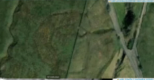
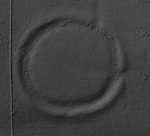
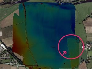
The stats for this Neolithic monument are astounding: 200m across, once a great circle of earthen banks and deep ditches. Today, almost lost: 5,000 years of plough and neglect have flattened the banks and filled the ditches, and Cana Henge is now nothing but a smoothly undulating grassy field on the moor overlooking Ripon.
Category: Henge
Dryburn Henge, Cumbria
Dryburn Henge lies on Alston Moor in Cumbria, within the North Pennines Area of Outstanding Natural Beauty. It occupies a strategic nodal point on the high moor, roughly at NY 760 430, where routes across the Pennine watershed converge. The surrounding terrain is underlain by Carboniferous Great Scar Limestone and interbedded Yoredale shales, with scattered fluvioglacial gravels in valley bottoms.
Castle Dykes Henge, Thoralby – North Yorkshire
Castle dykes it is a small class one henge, 90m across, perched on the high ground up in the North Yorkshire dales. The bank survives up to 1.5 m high in places, and the ditch up to 3 m deep. Early 20th-century reports (1908) noted its intact form, and recent LiDAR-based surveys have confirmed its classic henge profile with minimal later disturbance.
Moulton Henge
Archaeologists now recognise a true Neolithic henge lying immediately south-west of Moulton village, roughly midway between the Swale and Dere Street. The monument is almost 200 m across, with a low earthen bank encircling an inner ditch and a central platform about 110 m wide; the ditch lies inside the bank—the classic “Class II” henge arrangement.
Newton Kyme Henge
Newton Kyme Henge occupies a slight rise on the south bank of the River Wharfe immediately west of the village of Newton Kyme (OS grid SE 45945 44982), its maximum external diameter extending to around 250 m (heritagegateway.org.uk). The monument is best understood as a Class IIa henge of Late Neolithic–Early Bronze Age date, defined by three concentric ditch circuits with a turf-and-earth bank wedged between the inner and middle ditches.
- 1
- 2


