Notice: Function WP_Scripts::add was called incorrectly. The script with the handle "datatables-responsive" was enqueued with dependencies that are not registered: datatables. Please see Debugging in WordPress for more information. (This message was added in version 6.9.1.) in /home/u621095157/domains/brigantesnation.com/public_html/wp-includes/functions.php on line 6131
The Vale of Mowbray in North Yorkshire lies within a wide low-lying area bounded in the west by the Yorkshire Dales and the North Yorkshire Moors to the east. Within this is an area of land that sits mainly within the Vale of Mowbray that was of unique significance to our prehistoric ancestors. A corridor twenty miles long and bounded east-west by the rivers Swale and Ure was the location for the creation of a V-shaped alignment of henges and standing stones that created Britain’s largest Henge complex – marking the area out as perhaps the most important religious site in Britain during the Neolithic Period – an area that has been recently dubbed the “Sacred Vale”.
In approximately 3,000 BC, our Neolithic ancestors created an alignment of six massive and identical henges – huge circular Earthwork enclosures comprising a large circular earthen wall with ditches running around the interior and exterior to create a perfectly circular construction. This was a monumental piece of landscape architecture; it ran from Catterick in the north to Boroughbridge in the south.
At the southern end, where the two alignments met, they added the Devil’s Arrows – an alignment of massive standing stones.
This complex is highly unusual, not just because of the large number of enormous and identical henges, but also the two straight alignments are unique. Elsewhere, other monument complexes, including Stonehenge, were created, but these are collections of different monuments whose variety of design and irregular layout in every case proves a stark contrast to what is seen at the Sacred Vale. Here the layout is so regular that without excavation evidence one would be forgiven for suggesting these were modern copies or even (as was thought until very recently) of Roman origin.
It is these two factors – such a long linear alignment, and that it is constructed out of mainly identical monuments that mark the Sacred Vale as a place of unique and unparalleled importance, at the time that it was constructed and used, as will be explained later.
Henge Monuments in Britain
Throughout the British Isles, over 100 henges were built during the Neolithic period, some 5,000 years ago. As mentioned earlier, henges were earthwork structures, they were built by digging a circular ditch and by heaping the spoil to the outside of the ditch to create an enclosing bank. This created the basic henge structure, but there is no doubt that originally these were much more than the simple earthwork structures that we see today. Many incorporated large wooden structures that would have added significantly to the complexity of the original design.
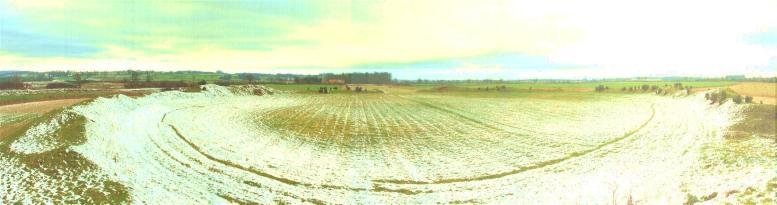
The image to the left shows the central henge at Thornborough. The darker lines show the ditches, the bank is shown by the lighter shading. This henge is 240m in diameter. and its bank may have stood as high as five meters.
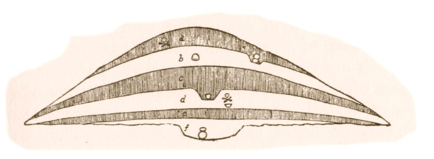
Excavation revealed that this was the product of many phases of building and re-working. Wooden posts formed a perimeter around and within the outer ditch. The henges within the Sacred Vale are almost unique in having an outer ditch. Normally, only a single inner ditch is found. The number of entrances varies. Evidence of timbers has also been found in the interior of the henge.
It is useful to think of henges as religious buildings, similar in use to the churches and cathedrals of the Christian period. This analogy is a “best guess” as we do not definitely know what they were for, but the evidence that can be seen indicates that a religious purpose was probably the most likely use of these ancient monuments, although this may not have been all they were used for.
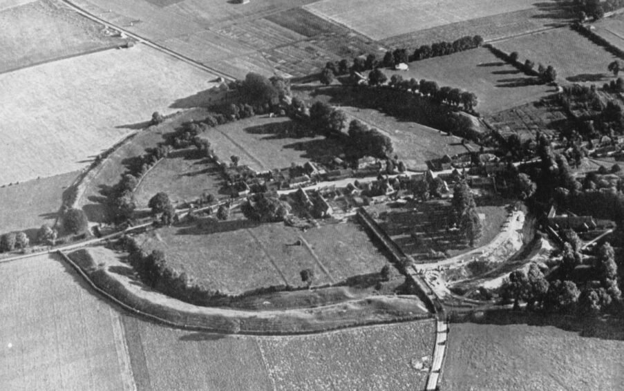
This image of Nunwick Henge, I believe, was taken shortly after the Second World War by Raymond Selkirk. I met and worked with Ray for some time during while I was researching Roman Brigantia. Raymond has since passed away, and I’d like to take this opportunity to remember that great man and honour his contribution to archaeology.
Raymond was one of the post-war pilots charged with photographing the significant ancient sites of England. He was also very active in researching Roman archaeology in particular, and ran an archaeology group from near his home, in Chester-Le Street, Durham. Before he died, Ray gave me full permission to publish anything from his book, Chester-Le Street, & its place in history, I’ve dug this out and will review it. Look out for further updates!
Many henges evolved, some getting additional Earthworks and some, often much later, having stones added to the outer banks. At Stonehenge, for example, the original earthwork structure was laid out in 3,100 BC, yet the stones were not added until seven hundred years later at the beginning of the Bronze Age.
It is this gradual evolution of henges and ritual sites that may well lead many to conclude that a site as impressive as Stonehenge had similar importance before the stones were erected. Few realise that Stonehenge started life as a 100m earthen henge.
Image: Hutton Moor Henge, North Yorkshire, Ray Selkirk.
An odd phenomenon regarding the later stone circle additions to henges is the predominant east-west split between those henges that later became stone circles, which are located mainly in the west of Britain, and those that retained an earth and wood structure, which are located mainly in the east.
Those henges that were adorned with stones were not the only important ritual places, and while stones were being placed at some sites, others continued to be adorned with wooden structures and also wood still played a major role at stone circles.
We must therefore try to judge like with like. When it was first built, Stonehenge was an earthen henge smaller than all the henges being built at the same time within the Sacred Vale. Things of course are not that straightforward, as we shall see.
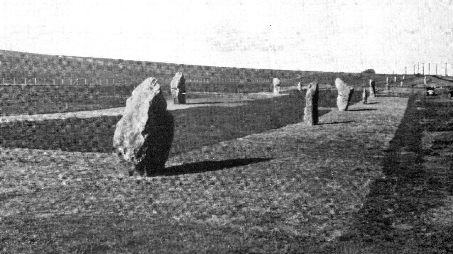
Image: Avebury Henge, Wiltshire. Major G. W. G. Allen.
Of all the henges built in Britain, almost all of them have a unique plan – they are individual one off constructions. This is especially true of the larger “super” henges such as Avebury or the less well known (yet largest of all henges) Durrington Walls in Wiltshire.
It is therefore highly unusual to find that within the Sacred Vale there were six henges built – each to an identical plan, each of them among the largest henges in Britain.
Of the seven henges within the Sacred Vale, six are almost completely identical – they are each 240m in diameter, they each are highly unusual in that they have both an inner and outer ditch, along with two entrances. The precise physical dimensions of these components, considering the varying levels of Preservation of the henges is the same. The only difference between the six henges, which, as we shall see, may be both important and expected, is the exact alignment of the entrances. It is this identical construction that leads to the suggestion that they were built to a single grand design and as a single construction event. Nowhere else can this be suggested on such a grand scale.
The effort involved in the construction of the monuments in the Sacred Vale cannot be over-emphasised. In a period of time when human population density is typically given
to be one person per square kilometre, these ancient people were able to create six identical monumental constructions – the work of perhaps thousands of people indicating that large numbers of imported workers were required for their completion.
It is worth noting that of the 100 plus henges found in Britain the vast majority are small and could be equated to small churches having diameters typically of 50m or less. Of the remaining larger henges, only a few, perhaps 15 or so are really massive – “super” henges – equivalent to cathedrals with diameters exceeding 100m.
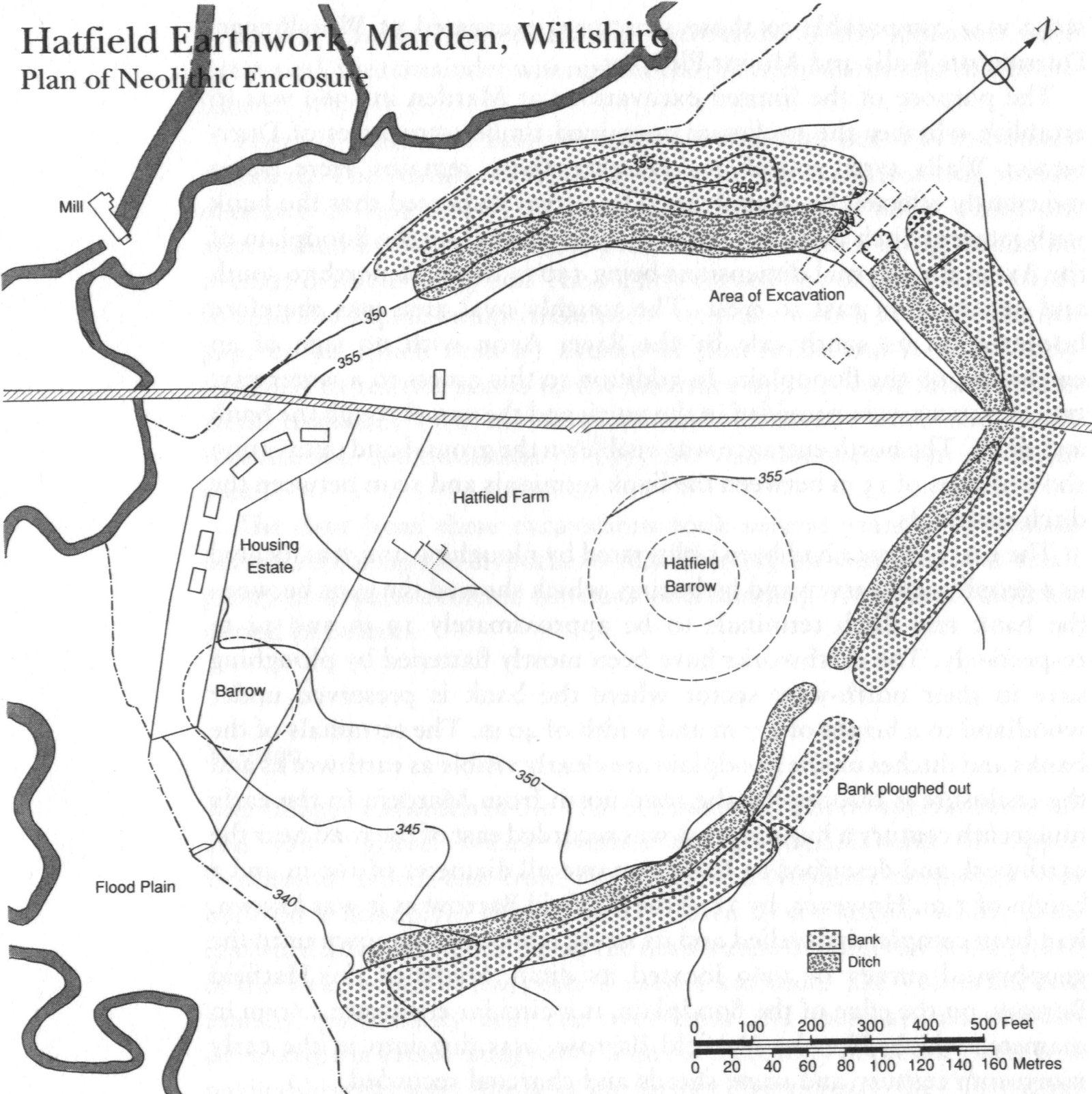
Image: Marden Henge, Wiltshire.
The very largest henges have been termed “henge enclosures”. None of these is truly circular in plan and one case is highly erratic in construction. The largest “henge enclosure” is Durrington Walls (approx 450m dia.), next is Marden, which is an incomplete enclosure (perhaps 400m average dia.), then Avebury (350m) and then Mount Pleasant in Dorset (320m). Each of these henges are single instances – they are all “one off” constructions.
Among the next largest henges in Britain are those of the Sacred Vale – each 260m in diameter and each of a more or less identical design. Three of these henges can be thought of as a single monument – those at Thornborough. Taken together, these create Britain’s largest henge structure.
This is why the Sacred Vale is so interesting; unlike elsewhere in Britain, during the Neolithic Period here were created a number of henges whose size and construction make them very likely to have been built simultaneously, by a large workforce and
Image: Durrington Walls, Wiltshire. 1927.
to a single plan. This is very different to what can be seen elsewhere; individual monuments built to a “one off” design, enhanced gradually and over a long period of time.
There are very few places in Britain that present the possibility of widespread governance during the Neolithic period. One exception to this general rule must be The Sacred Vale.
Henge Capital?
The title of this book suggests that Thornborough should be regarded as a capital location for Britain. It would be a good idea to clarify exactly what I mean by “capital” in this distant part of our past.
Six thousand years ago, major changes occurred in the way that people in Britain behaved as a social Group – changes that were to have profound social and environmental impacts. Around 4000BC, the primarily nomadic society based on hunting and gathering that had been prevalent in Western Europe for half a million years or so, began to die out. Instead, the way of life began to transform into one that involved farming and the keeping of domestic livestock. This change ran far deeper than simply the way the people of Britain obtained food.
This was a period of rapid change. Technological and social developments created new social structures and practices, new attitudes to the landscape and the natural world. New forms of tools and belongings were adopted, the development of new beliefs that involved traditions of monument construction. This period is known to archaeologists as the Neolithic, and is recognised to have lasted from about 4,000 BC to around 2,500BC.
Image: West Kennet Avenue, Avebury, Wiltshire. S. Piggot.
This change of lifestyle brought about a dramatic shift in society, it saw the introduction of specialist craftsmen and an increasingly wide geographic distribution of goods indicative of extensive and in some cases very long-distance trading patterns.
During this time in Britain, there were (to our knowledge) no cities. So what would constitute a capital location in this context?
Many investigations over the years have confirmed that the Later Neolithic period saw a huge expansion in religious monumental constructions, exemplified by the henge monuments. In many ways the Neolithic Period can be seen as the birth of modern society, for whilst the tools and technology available were very different to those today, this was a time when ideas such as religion, trade and social order appear to have taken shape and formed permanent aspects of British life. From this time forward, every region in Britain appears to have adopted common forms of religious expression whose size and dominance over the landscape indicate that
widespread mechanisms of social control had established. Whatever they called themselves, there were leaders and some form of priesthood.
The Late Neolithic, with its sudden explosion of monumental religious buildings, should be thought of as a time of great socio-religious change. If henges were indeed the churches of their day, then it should be acknowledged that this phenomenon occurred throughout the country on a massive scale. As such, this was a time of universal acknowledgement of the importance of religion.
It is therefore reasonable to ask if some centres took on a role of particular importance – places whose ritual events attracted not only the local population but also had a national significance, perhaps regarded as prime locations for long-distance pilgrimage.
It is also reasonable to ask if one of these locations had an importance above all others. This is the question that is being asked of the Sacred Vale, Thornborough in particular, and it is what is meant by the phrase “Henge Capital”.
It should be noted that the Neolithic period is one of the least understood periods of human experience. Very little real evidence exists and much of what we call evidence is really based on interpretation of tiny pieces of evidence that have survived the millennia. This partial evidence gives a very disjointed and blurred indication of life in the past. The ritual complex found in the Sacred Vale itself challenges many people’s preconceptions of the complexity of civilisation in Britain at this distant time. This book therefore acknowledges that the inferences made may be wholly inaccurate. However, the evidence we have is all that is available and the interpretation within this book is an attempt to understand what is most likely.
“Ritual” monuments
Henges are not the only ancient monuments to be thought of as having a ritual or religious purpose.
The earliest ritual monuments were used for burying the dead and they are typically called Barrows. These come in a wide variety of forms and the name applies to burial mounds created from the Neolithic until the Saxon period. The structure of the mound, the method of burial and the ritual importance of the grave varied considerably other this time.
Image: Reconstruction of West Kennet Long Barrow, Wiltshire. B. Windle.
The earliest barrows were constructed around 3,500BC. These were large stone chambers that housed multiple burials covered with a long mound of earth. The most famous of these Long Barrows is at West Kennet in Avebury. Archaeologists have interpreted these as being in use for a long period of time – probably these tombs were of tribal significance and reserved for important ancestors. The remains of the dead appear to have been regarded as having a major impact on the living.
Because there are so few of the earliest burial monuments, and their construction took a considerable amount of effort, many regard these early spectacular monuments as being reserved for “kingly” burials – people of very high status.
As time passed, other types of burial mounds appeared. The most common type is the Round Barrow – a small circular hill constructed over one or more burial pit. The area then bounded by a circular ditch.
Image: Section through barrow with multiple internments. B. Windle.
Round Barrows appeared during the Neolithic period and continued in use until the post-Roman period. In some cases, earlier burial mounds were re-used more than a thousand years after they were first constructed, and it would appear that in the Bronze Age there was a need to link the recently deceased with the kingly burials of the past.
At the same time as the burial mounds began to appear, another ritual monument appeared in the British landscape – the cursus. Cursus monuments are long strips of land bounded by a ditch. Looking rather like Roman roads, these typically dead straight monuments are seen as “processional ways” – places where larger communal ceremonies could be performed, perhaps before burials but also possibly for other reasons.
The largest cursus is in Dorset; this is 20 miles long. Of the 70 or so other cursuses known in Britain, many are limited to a length of 1–2 miles and perhaps 50-100m in width. Burial mounds are often found clustered around cursuses, emphasising their potential ritual function.
Around 3,000BC there was a change in the design of ritual monuments. Cursuses appear to have gone out of use and the first henges appeared – circular structures that again tended to act as a focus for burials.
Henges appear to have enjoyed a longer life than cursuses. Most were rebuilt and remodelled several times. By 2,500BC, a large number had standing stones added reflecting the circular structure of the henge.
Image: Two of the three remaining giant monoliths that constitute the Devil’s Arrows at Boroughbridge. George Chaplin.
It is also at this time that most of Britain’s standing stones were put in place. These are included among our most enigmatic monuments since there is the least known about them, yet their construction took a significant amount of effort.
Thornborough Central Henge – by Chris Collier.
This list is by no means comprehensive, but does reflect the majority of ancient ritual monuments that are still visible today.
More about the Sacred Vale
The Vale of Mowbray in North Yorkshire sits on a broad plateau formed largely of the flat flood plain between the North Yorkshire Moors and the Yorkshire Dales. It is a place where numerous rivers meet having emerged from the higher ground in the Dales to the west. The area that was chosen for the Sacred Vale can be regarded in modern times as being typical of today’s many English river valleys. There is a range of features – pretty cottages, English gardens, open green fields and arable farms. This is a landscape that could be said to be typical of those found in many river valleys up and down the country.
The “Sacred Vale” is a monument complex that sits largely within the Vale of Mowbray and is between the Rivers Ure and Swale; the area stretches broadly from the town of Catterick in the north, to Boroughbridge in the south. This forms a tract of land approximately 20 miles north to south and 10 miles east to west. The rivers form a confluence at Boroughbridge, creating a “V” shaped plateau.
Located here is a wide expanse of glacial alluvial deposits – sand and gravel deposited as the glaciers retreated after the last Ice Age. For at least 5,000 years
the local economy has relied mainly on the arable farms of this lowland plateau, together with the products from sheep farming in the hills that form the edge of the Yorkshire Dales to the west, and to the east the Hambledon Hills. Of the local market towns, these include Masham – famed for its twin breweries and annual sheep fair, Ripon – home to its Cathedral and Fountains Abbey, Boroughbridge – close to the Roman capital of the Brigantes at Aldbrough, and Thirsk, Northallerton and Bedale – ancient market towns.
The area in general has been largely overlooked by modern developments, and as such still readily retains its reputation as a little-known rural idyll.
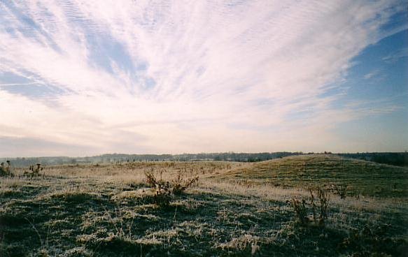
Image: Northern Henge at Thornborough – the best-preserved henge in Britain. D. Raven
It appears that this lack of significant and widespread development over the last few thousand years has left us with a number of largely unknown archaeological gems. The Neolithic monument complex that creates the Sacred Vale is one such item; its story is a magnificent testimony to a significant national religious culture, one that was able to organise manpower to previously unprecedented levels.
The image that we see today is misleading in the sense that the Vale of Mowbray has a remarkable prehistoric landscape. The Sacred Vale is highly suggestive; the area was a place of some considerable national importance in the prehistoric period. Hidden within this plateau is a series of impressive ancient monuments. These are not just impressive – they are some of the biggest and most spectacular monuments in the whole of the British Isles and taken together, they may well be the most important construction of the Neolithic period.
Within the Vale of Mowbray, 5,000 years ago were created a series of monuments that formed a complex set of two linear alignments. At Thornborough, three identical henge monuments were created; a straight line drawn between here and the Devil’s Arrows stone row at Boroughbridge, 8 miles to the south, reveals
another identical henge at Nunwick – slightly to the north of the mid-way point. Another line drawn northwards between the Devil’s Arrows and Catterick reveals two more identical henges located approximately three and four miles to the north of Boroughbridge – these are Hutton Moor and Cana Barn.
Image: The Southern Henge at Thornborough, the least well-preserved of the three monuments, D. Raven
At Catterick, a recently discovered henge sits under the racecourse to complete the longest alignment. Together, these eight massive constructions form the largest monument complex of the Neolithic Period in Britain, the only large-scale complex created with six identical henges in Britain, and at Thornborough we have the only single site with three identical henges.
The monuments date to the period known archaeologically as the Late Neolithic and early Bronze Age. In chronological terms, they date from the period of 3,500 BC to around about 1,500 BC.
The nature of religion could be seen as a centralizing force, providing a focus on specific locations of spiritual importance. The majority of religious cults identify key locations that are deemed of great significance and tend to form the focus for pilgrimage. Often, these pilgrimages are at fixed points – regular events are held to this day throughout the world that testify to our propensity for regular religious pilgrimage. The pilgrimage by millions to Mecca each year serves as a good example of this.
The importance of these monuments needs to be emphasized. It is not an over exaggeration to say that during the Neolithic and early Bronze Age periods, these monuments were known far and wide; they were famous, their fame was known in communities covering a large stretch of England. During the Neolithic period, the Sacred Vale was a place of renown, it was of national importance.
This was not typical by any stretch of the imagination; it was a place of magic, a place whose mystique spread on a national scale. It was, to Neolithic communities as Canterbury cathedral is to the Christians of later years, as Mecca is to Muslims. It had a religious resonance that spread far beyond today’s local or even regional boundaries, it was perhaps even more important than any of this, for within the Sacred Vale the Neolithic people did not build a single Canterbury Cathedral, they built six! Each of them identical and maintained as a single unit – refurbishment happened at all six locations simultaneously; maintaining the same design throughout the active life of the monuments, which may have been more than 1,000 years.
One of the key aspects of the archaeology within this landscape is that it would appear that the setting of the henges was respected for far longer than has been noticed with other similar monuments. This may have been due to their prior fame, and also to the area’s lack of modern development.
If we think about the henges in the same way as we think about cathedrals, for example, where the cathedral grounds and the wider landscape also form a natural part of the setting of the cathedral (to the extent that there are certain things not allowed within certain distances), we do not live within a certain radius of the cathedral; this respect for the area is typically retained and enforced long after the cathedral ceases to exist as such. To a large extent, the archaeology of the henges bears this out. For example, the flint scatters found show that there was potential for a number of settlements, but all of these tend to keep a safe distance from the henges – about 500m or so.
Furthermore, from the evidence found to date (except for a short period of time in the Middle Ages and a single Roman kiln) the surrounding area seems to have been largely “respected” as a place of reverence even after it ceased to be used as a major gathering place. Its burial grounds continued to be used for at least another two thousand years.
This long-term respect of the ritual landscape of henges within the Vale of Mowbray bodes well for future studies, since it means that a great deal of evidence still remains to be found and understood within this very large-scale landscape.
Unfortunately, as we move into the twenty-first century, we find the lack of attention from archaeologists and the public alike has left this monument complex vulnerable to great damage from development. High-powered modern ploughing has flattened many of the henges and destroyed the archaeology closest to the surface. More recently, large-scale quarrying has removed significant portions of the ritual landscape of both Thornborough and Catterick henge sites.
Note: This book was written before the second henge at Catterick was found, I think once I’ve published this original version of the book, I’ll either, bring it up to date, or do something different…


")


