

A gazetteer of probable prehistoric mounds, cairns and boundary earthworks in Coverdale. It is not complete and is still being researched.
Jun 27
A gazetteer of probable prehistoric mounds, cairns and boundary earthworks in Coverdale. It is not complete and is still being researched.
May 22
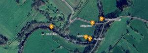
Nathwaite Bridge, over the river Cover in Coverdale, is just about the only way any heavy traffic can easily cross between the key villages of Carlton and West Scrafton. The importance of the location is perhaps underlined as the last place down the river Cover where it remains reasonably ford-able, and therefore crossable in past times when no closer bridge existed.
May 20
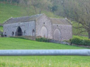
Even in a rural community of mainly farmers, there are often reasons to wish to build or create a structure that is for, at least in part, for defensive purposes. Thus, some barns in Yorkshire and other places can be seen to have “arrow slits”, and later, square “gun ports”. This article provides a brief overview of what these structures are, why they were built and how they were used.
May 20

“Coal Barns”, are, in the case of Coverdale, and smaller coal producer, often, simply ordinary barns, which have been used, and perhaps partially converted for use as coal storage.
 NLS Map Explorer
 Google Earth
 Google Maps
 Lidar Finder
 TMA
TMA
 Megalithic Portal
 Yorkshire Arch. Air Mapping
 ADS
ADS
 Brigantian Adventure FB Group
Stone Bothering FB Group
Stone Faces FB Group
Brigantian Adventure FB Group
Stone Bothering FB Group
Stone Faces FB Group
 Heritage Gateway
 ARCHI® MAPS: UK
 Atlas of Hillforts
 Portable Antiquities
 British History Online
Brigantes Nation FB Group
British History Online
Brigantes Nation FB Group

