
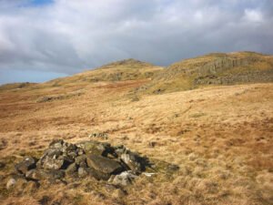
On every late-Victorian and early-20th-century OS sheet the surveyors marked any conspicuous heap of stones they could not instantly classify as a tumulus, beacon, trig-point or boundary stone with the catch-all term “Pile of Stones.”
Jun 15
On every late-Victorian and early-20th-century OS sheet the surveyors marked any conspicuous heap of stones they could not instantly classify as a tumulus, beacon, trig-point or boundary stone with the catch-all term “Pile of Stones.”
Jun 07
Synthetic-aperture radar (SAR) already relies on Doppler shifts: echoes from scatterers in a side-looking radar beam have slightly different frequencies as the platform flies past, and focusing those micro-shifts yields a two-dimensional image.
Jun 05

Archaeologists use the word “henge” for later-Neolithic and earliest Bronze-Age earthen rings whose ditch lies inside the bank, creating a deliberately bounded interior. The term itself was coined in 1932 by Kendrick; it was refined in the 1950s by Richard Atkinson, whose system still frames most discussion.
 NLS Map Explorer
 Google Earth
 Google Maps
 Lidar Finder
 TMA
TMA
 Megalithic Portal
 Yorkshire Arch. Air Mapping
 ADS
ADS
 Brigantian Adventure FB Group
Stone Bothering FB Group
Stone Faces FB Group
Brigantian Adventure FB Group
Stone Bothering FB Group
Stone Faces FB Group
 Heritage Gateway
 ARCHI® MAPS: UK
 Atlas of Hillforts
 Portable Antiquities
 British History Online
Brigantes Nation FB Group
British History Online
Brigantes Nation FB Group

