Notice: Function WP_Scripts::add was called incorrectly. The script with the handle "datatables-responsive" was enqueued with dependencies that are not registered: datatables. Please see Debugging in WordPress for more information. (This message was added in version 6.9.1.) in /home/u621095157/domains/brigantesnation.com/public_html/wp-includes/functions.php on line 6131
Scholes (or Scoles) Coppice Camp (sometimes called “Caesar’s Camp”) lies just north-west of Kimberworth in Rotherham, atop the same Magnesian Read more
Despite is unusually high position, this fort contains traces of a number of huts, and on investigation these have yielded Read more
Templeborough Roman Fort
Templeborough Roman Fort occupies a commanding position on the north bank of the River Don at Rotherham (OS grid SK 410 916), where the Magnesian Limestone ridge drops into the floodplain. Originally constructed in timber and earth in the mid–1st century AD, it was later rebuilt in stone and occupied—possibly intermittently—until the withdrawal of Roman authority in the early 5th century AD (en.wikipedia.org).
Fort Layout and Phases
Early excavators identified three major construction phases on the site. The first, dating to c. AD 50–80, comprised a roughly square earth-and-turf fort measuring c. 150 × 148 m (5½ acres), with a turf rampart atop gravel-and-clay foundations and a single external ditch separated by a 4 m-wide berm (roman-britain.co.uk).
In the late 1st or early 2nd century, the defences were reconstructed as a smaller stone fort (c. 116 × 134 m; 3¾ acres) with a 2.7 m-thick stone wall backed by a clay bank and fronted by an 18 m-wide ditch (roman-britain.co.uk).
A final stone refurbishment in the late 3rd century reinforced the wall and re-cut the ditch, marking Templeborough’s long-lived strategic importance (tandfonline.com).
Excavations and Key Finds
Leader & Guest (1877–78): The Rotherham Literary & Scientific Society’s initial trenches uncovered burnt layers indicating that the timber fort was twice destroyed by fire, and revealed pottery from Augustus through Constantine I (en.wikipedia.org).
Thomas May (1916–17): As steelworks construction threatened the fort, May’s rescue excavation recorded the stone ramparts, identified the three building phases, and recovered tile stamps of Cohors IV Gallorum (Domitianic–Trajanic), plus tombstones of soldiers and civilians—among them one of the earliest memorials to a named British woman (en.wikipedia.org).
20th–21st Century Work: Limited watching briefs and geophysical surveys by ARCUS/ArcHeritage prior to the Magna Science Adventure Centre development re-mapped the defensive ditches and located the vicus (civil settlement) spread to the north and east, complete with timber workshops, metal-working slag and bath-house foundations (local-heritage-list.org.uk).
The Vicus and Industrial Activity
Immediately north of the fort lay a bustling civilian settlement, whose timber buildings and back-street industries produced ironwork, ceramics and tanning. A well-preserved bath-house sat beside the Don, fed by a spring first captured in the 2nd century AD. Finds of nails, hobnails and smithing debris attest to ongoing local manufacture well into the 4th century (visitmagna.co.uk).
Strategic and Cultural Significance
Templeborough guarded the key crossing of the Don and controlled routes from the West Riding into the Humber basin. Its repeated rebuilding—first in turf, then in stone—reflects changing military and administrative needs as the Roman presence in northern Britain evolved. The presence of the Fourth Cohort of Gauls, commemorated on tile stamps and tombstones, underscores the fort’s role in wider imperial logistics and frontier diplomacy (en.wikipedia.org).
Legacy and Public Access
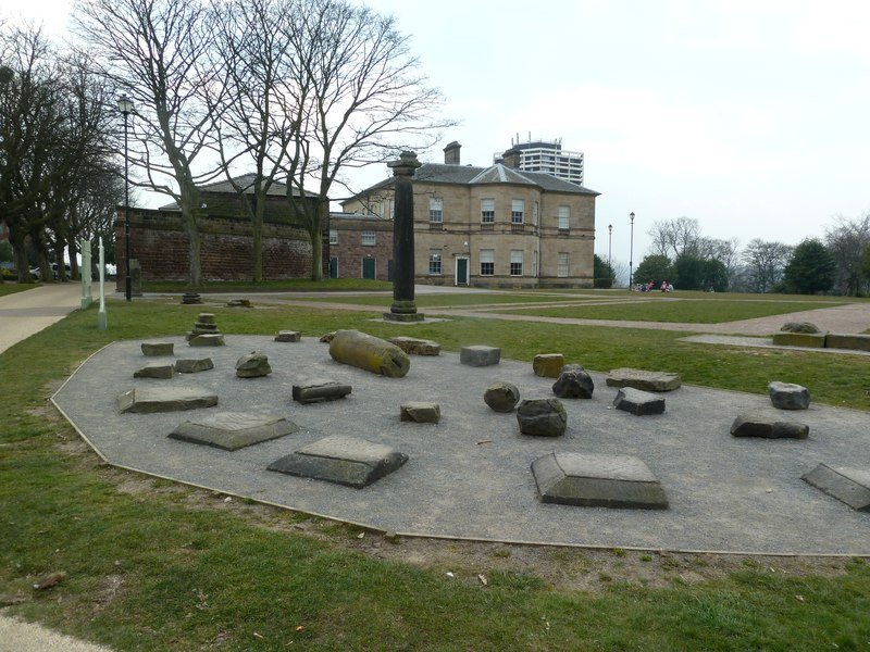
Though largely buried beneath 20th-century steelworks, parts of the ramparts and ditches were preserved and are now interpreted at the Magna Science Adventure Centre. Many of the original granary columns were re-erected in Clifton Park (1922), and key finds—tombstones, tile stamps and industrial waste—are displayed in Rotherham’s Clifton Park Museum (en.wikipedia.org).
Together, these investigations paint Templeborough as a multi-phase, strategically vital fort whose civilian hinterland and industrial footprint reveal the complexity of Roman military and economic networks in South Yorkshire that was in place in time to be at the potential leading edge of the Roman push northwards into Brigantia.