Location: Lancashire

Liverpool Street Roman Road, Manchester

Liverpool Street Excavations - Roman Road - Manchester University

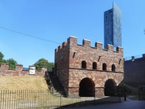
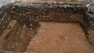
Archaeologists have exposed a well-preserved cambered Roman road surface in Manchester’s Castlefield area (Liverpool Road/Liverpool Street reporting), astonishingly only c. 15 inches (≈38–40 cm) below modern tarmac, with an assemblage of Romano-British pottery and other small finds broadly dating its active use to the 1st–3rd centuries AD.

Mamucium Roman Fort, Manchester

Roman Gatehouse at Mamucium

Mamucium occupies a low sandstone promontory at the junction of the Rivers Medlock and Irwell. The bedrock is the Triassic Sherwood Sandstone Group, a firm, well‑drained red sandstone that gave Roman engineers a stable platform for earthworks and timber palisades, while nearby river gravels supplied road‑making aggregate.

Roman Road to the West uncovered under Manchester Street

Sections of a Roman road can be seen in this trench

A stretch of Roman road just 38-40 cm (15 in) below Liverpool Road in Castlefield. The trench shows the classic Roman construction sequence – a cambered rubble core surfaced with tightly packed cobbles – and runs on a north-east/south-west alignment that leaves Mamucium’s north gate and heads towards modern Salford.

The Brigantes of Lancashire

An image illustrating an article about The Brigantes of Lancashire on thealicesyndrome.com

An interesting heading in Robert Morden’s map of Lancashire (1695) places “The Brigantes” in Lancashire. Worth investigating to try to understand exactly what Robert Morden was trying to portray here.

Castercliff Hill Fort

This denuded hillfort is oval and encloses almost two acres. The defences comprise triple circuits of bank and ditch, with scarps representing outworks to the NE. The innermost bank is the slightest and may represent an earlier, univallate fort.

Brigantia

Carton Castle - Google

The name Brigantia represents three separate concepts: a goddess, a people, and a tribal federation. By the Roman period, the name represented a tribal federation compromising all of what would become the Roman province of Britannia Secunda, except for the Parisi territory, east of the River Derwent.

Lancashire

← World Heritage Arka Unskel hillfort, Highlands Arka Unskel is 2½ miles ESE of Arisaig at NM693839 and has also been known as Arisaig Fort, Ard Ghaunsgoik Read more Castle Hill, Almondbury Castle Hill’s imposing silhouette hides a great prehistoric fort, Norman castle and Victorian tower. Thanks to Varley’s trenches and the Read more West …

Continue reading

Contact Us
close slider