Category: Finds

The Story of Boltby Scar

Boltby Church, Yorkshire Moors

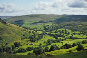
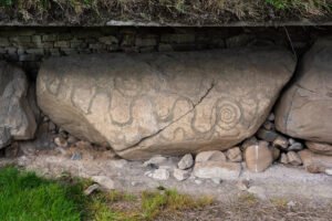
Boltby is a very important ancient site IMO. A gold “hair braid”, was found there, linking it to the Amesbury Archer, buried with two similar hair braids. This also provides a link to the founding of Stonehenge, which helps set a potential scene for a possible “zeitgeist”, of the day.

Swaledale

2015 Swaledale from Kisdon Hill

Swaledale occupies the long, sinuous valley carved by the River Swale on its 45-kilometre descent from Nine Standards Rigg (662 m) on the Pennine watershed to Richmond in lower Teesdale. The dale narrows between rough gritstone scarps near Keld, broadens to a patchwork of hay-meadows around Muker and Gunnerside, then opens into a tree-fringed flood-plain west of Reeth before the river cuts through the Carboniferous escarpment to meet the Vale of Mowbray.

Head One – St Michaels Church, Kirklington

Kirklington Head 1 - left side

This head is one of thirteen “Celtic”, or archaic heads that are located within the interior of the church. Twelve of those heads, including this one, are located in four rows of three, which run down either side of the churches arched columns. The thirteenth head is located in the bell tower.

Anciens Arsenaux Neolithic Settlement, Sion – Switzerland

Upper Rhone Valley

Sion lies midway along the upper Rhône Valley, an east‑west trench gouged by repeated Pleistocene glaciers and now flanked by the Pennine and Bernese Alps. The settlement area sits on the alluvial fan of the Sionne torrent, a cone of well‑sorted sands and gravels that projects onto the wider Rhône flood‑plain. 

Snake Iconography in the British Isles

Knowth, Brú na Bóinne (Boyne Valley), Ireland

Syncretism through the ages Syncretism, the amalgamation of different religions, cultures, or schools of thought, has its roots in the ancient world. Thoughts on Celtic Religion – Raimund, Karl To begin with, lets first look at the sources available to us: There are quite numerous sources available, contrary to Read more Hillforts: Defence or Ritual? …

Continue reading

Wiltshire

Silbury Hill, Wiltshire

Lying across the spine of southern England, Wiltshire offers a textbook cross‑section of chalk downland, greensand vales and clay lowlands. Its long archaeological record – from 10 000‑year‑old spring‑side camps to modern military landscapes – is inseparable from that underlying geology and from the climatic swing that ended the last Ice Age.

Liverpool Street Roman Road, Manchester

Liverpool Street Excavations - Roman Road - Manchester University

Archaeologists have exposed a well-preserved cambered Roman road surface in Manchester’s Castlefield area (Liverpool Road/Liverpool Street reporting), astonishingly only c. 15 inches (≈38–40 cm) below modern tarmac, with an assemblage of Romano-British pottery and other small finds broadly dating its active use to the 1st–3rd centuries AD.

South Street Long Barrow, Avebury

South Street Long Barrow - Stukely plate including South Street Long Barrow

South Street long  barrow once lay 1 km south‑west of Avebury village, midway between the Kennet spring‑line and the Windmill Hill plateau (OS grid SU 090 678; 165 m OD). From its crest the ground falls gently north‑east toward the henge and west toward Beckhampton, so the mound would have been visible from all Early‑Neolithic foci in the area yet lay on good grazing that could be tilled by the first farming groups.

Mamucium Roman Fort, Manchester

Roman Gatehouse at Mamucium

Mamucium occupies a low sandstone promontory at the junction of the Rivers Medlock and Irwell. The bedrock is the Triassic Sherwood Sandstone Group, a firm, well‑drained red sandstone that gave Roman engineers a stable platform for earthworks and timber palisades, while nearby river gravels supplied road‑making aggregate.

Millbarrow long barrow (Winterbourne Monkton)

Tumulus on Millbarrow

Millbarrow once stood on a low chalk spur 2 km north‑west of Avebury, just above the spring‑line where the Kennet valley opens onto the Marlborough Downs (NGR SU 0943 7221). From its east–west‑aligned crest the ground falls gently south to Windmill Hill and east  into the Kennet valley, giving the mound clear sight of the Avebury monument complex, and easy access to water and pasture.

Contact Us
close slider