Archaeologists now recognise a true Neolithic henge lying immediately south-west of Moulton village, roughly midway between the Swale and Dere Read more
Hutton Moor Henge is almost identical the the henges at Thornborough and Nunwick. It's been proposed that these henges form Read more
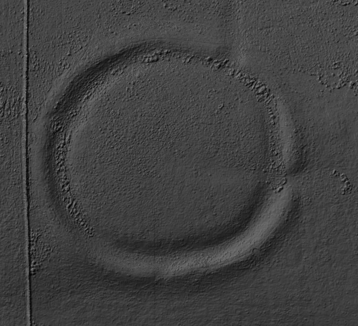
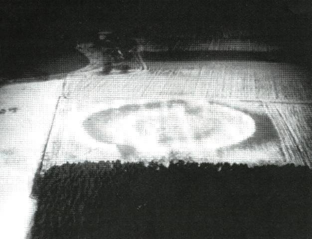
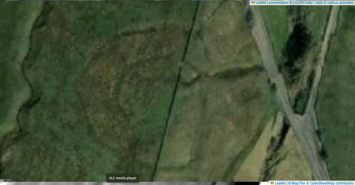
Dry Burn enclosure - Satellite - LiDAR Finder
Dryburn Henge/Enclosure
Location and Landscape Context
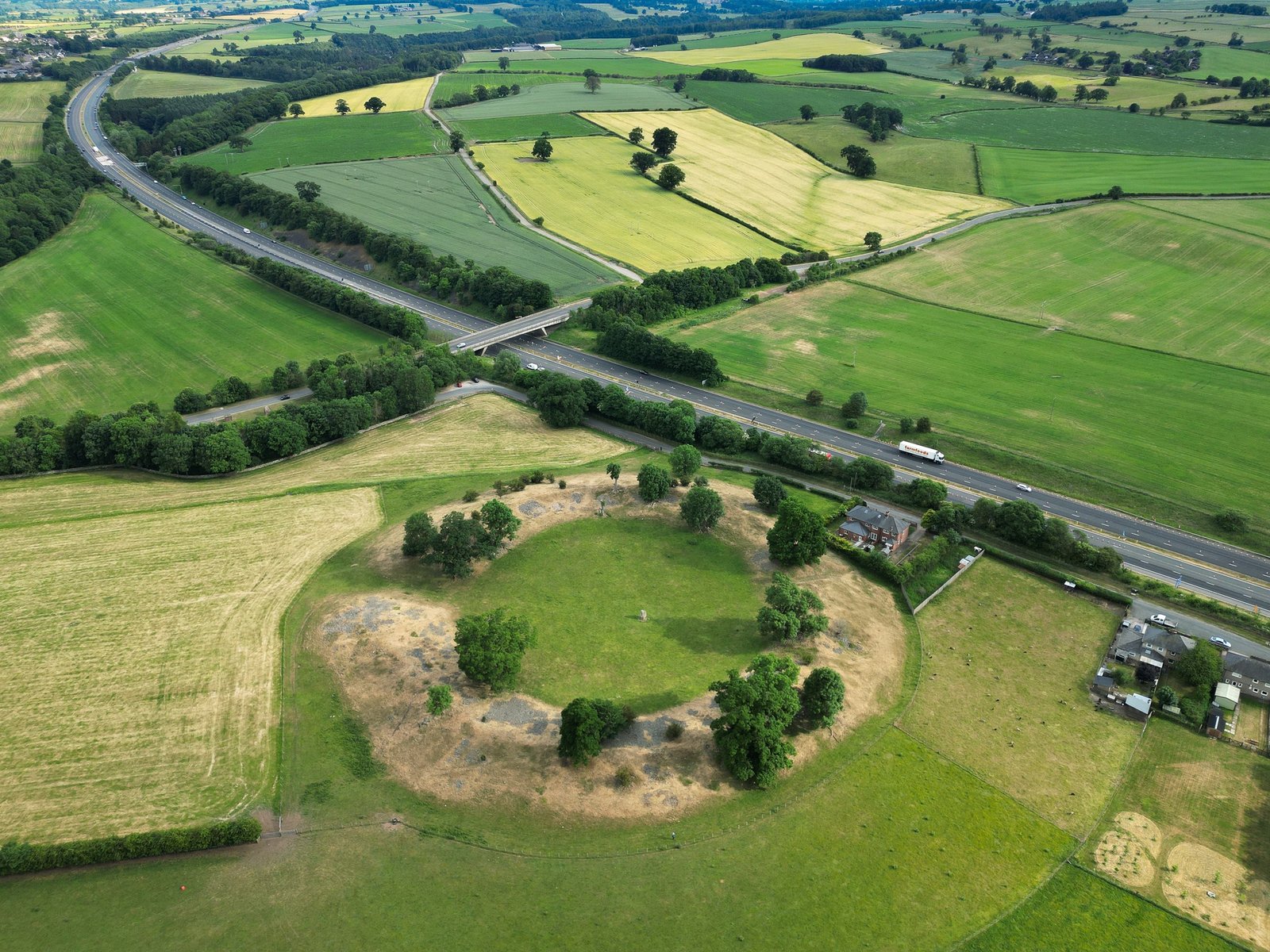
Dryburn Henge lies on Alston Moor in Cumbria, within the North Pennines Area of Outstanding Natural Beauty. It occupies a strategic point on the high moor, being located at the very centre of Alston Moor, at a key strategic and routeway point. It is located roughly at NY 760 430, where routes across the Pennine watershed converge. The surrounding terrain is underlain by Carboniferous Great Scar Limestone and interbedded Yoredale Shales, with scattered fluvioglacial gravels in valley bottoms. Heather-clad moorland and peat bogs dominate the immediate vicinity, offering expansive views toward the Eden and Tyne valleys .
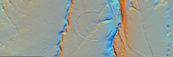
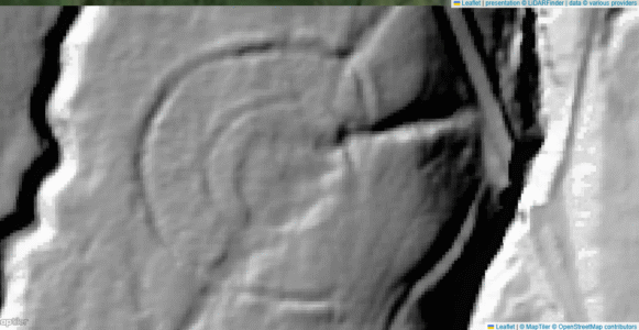
Dry Burn enclosure - 1m Lidar - National Museum of Scotland
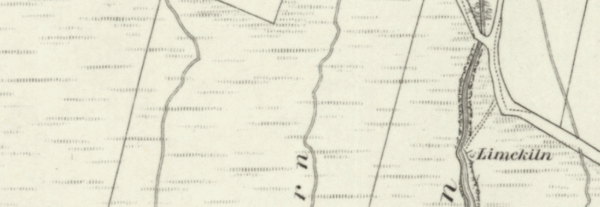
Dry Burn enclosure - OS Series 1 - National Museum of Scotland
Geology and Geography
The henge’s builders chose a natural plateau on the limestone–shale interface, where shallow soils overlie weathered bedrock. Springs at this lithological junction provided water, while nearby copper-bearing veins in the limestone likely attracted Neolithic travellers. The moor’s upland environment suggests primarily seasonal use, with the henge serving as a focal point in a largely transhumant landscape .
Monument Structure
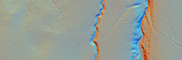
Dryburn Henge is a roughly circular Earthwork, measuring c. 40–45 m in diameter internally. Its defining features are:
Inner bank: Made of turf-faced earth and cobble, standing up to 1 m high.
Internal ditch: Stands 4–5 m wide and 0.5–1 m deep, set just inside the bank.
Single entrance gap: Located on the southeast side, aligned with a likely trackway across the moor.
Subdued external counterscarp bank: Seen in places, marking what is assumed to be the original outer boundary .
No internal stone or timber settings have survived, and there is no visible central platform—suggesting Dryburn was a purely earthen henge (Class I type).
Dating and Archaeological Investigations
Altogether Archaeology (ASDU) undertook small-scale excavation and post-excavation analysis in 2016. Charcoal from the primary ditch fill produced radiocarbon dates in the late third millennium cal BC, placing Dryburn firmly in the terminal Neolithic (Chalcolithic) period . No associated occupation debris or structural remains were found, leaving its exact function open to interpretation.
Interpretation and Significance
Dryburn Henge’s location at a convergence of cross-Pennine routes implies it functioned as a ritual waypoint or meeting place for communities moving between the Eden and Tyne corridors. Its construction in a remote upland setting underscores the Neolithic emphasis on landscape marking far from settled lowlands. Because it provides one of the few radiocarbon-anchored examples of a small, earthen henge in the North Pennines, Dryburn expands our understanding of how ritual monuments punctuated travel and exchange networks across Britain’s high moors .
A complete silver Scottish twelve shillings coin of James VI of Scotland and I of England, eighth coinage post-dating accession to English throne, dating to 1603-1625, Lys initial mark. Reverse has a shield with arms of [...]
A silver Post-Medieval shilling of Elizabeth I, third issue with ‘A’ initial mark dating to 1583-1585. Mint of London. As North Vol 2, p.136, no.2014. [...]
A lead alloy pipe tamper dating to the 17th century. The plate has moulded decoration to both sides depicting Charles I (facing right) and Henrietta Maria of France (facing left). Both images are contained in [...]
A damaged lead-alloy Medieval pilgrim's ampulla, 50mm in length and 35mm wide, with a round bodied flask with a flaring open top which is partially complete. One side of the flask body has traces of moulded [...]
An incomplete Medieval cast copper alloy buckle plate, dating to c. AD 1100-1400. The plate is missing its buckle and part of its sprues. The buckle plate is sub-rectangular in plan. Projecting from one long edge [...]
A Roman copper-alloy nummus of the House of Valentinian , dating to AD 364-7 (Reece Period 19), GLORIA RO-MANORVM reverse type depicting the emperor with right hand dragging captive right and holding a labarum in left hand. Mint of [...]
A Post-Medieval copper alloy farthing of Charles I (AD 1625-1649), dating to AD 1636-1644. Rose type 2, with sceptres in saltire through single crown. Mint of London. Unclear initial mark. North (1991: 165) no. 2291. [...]
A clipped and heavily worn Roman copper alloy nummus of Gratian (AD 367-383) dating to the period AD 367-378 (Reece period 19). SECURITAS REI PUBLICAE reverse type depicting Victory advancing left, holding a wreath and palm. Unknown mint. [...]
A silver Roman siliqua of Honorius (AD 393-423) dating to the period AD 397-402 (Reece Period 21) minted in Milan VIRTVS ROMANORVM reverse type depicting Roma seated left on cuirass, holding Victory on globe and spear. Hoxne, p. 145, no. [...]
An incomplete Roman composite plate brooch probably dating to AD 100-200. The brooch is missing it's pin and part of the top and bottom circles. The brooch is flat in cross section and probably originally consisted of [...]
Fragment from a probable buckle frame dating to the Post Medieval period (c.AD 1720-1790). The fragment is broadly rectangular in plan and includes a short section of the corner of the buckle frame. The fragment includes the [...]
Fragment from a buckle frame dating to the Post Medieval period (c.AD 1720-1790). The fragment is broadly C shaped in plan and D shaped in profile. It consists of two corners and one side of a sub-rectangular [...]
A complete copper alloy bovine (bull's head) vessel / bucket mount, dating to the Roman period (c. AD 50-200).The cast copper alloy mount is a sub-inverted triangle with a pointed lower tip and slightly waisted sides to form the nose.The [...]
An incomplete copper-alloy early Medieval stirrup strap mount of uncertain or unclassified type, dating to c.AD 1050-1150. The central part of the object survives with parts of the open work broken off on all sides except [...]
A near complete Medieval-Post Medieval cast copper alloy buckle with integrated plate dating to the period c.AD 1250-1500. The buckle is missing its pin.It has a rectangular frame, which has a sub rectangular cross-section. The integral plate has [...]
A very worn copper-alloy Roman radiate or nummus of unclear ruler dating to AD 260-402. Unclear reverse type, unclear mint.The coin is chipped around its circumference. [...]
A very worn Roman copper alloy radiate of uncertain emperor dating to the period AD 260-275 (Reece period 13). Unclear reverse type depicting. Unclear mint. [...]
An incomplete Medieval cast copper-alloy rectangular buckle with integral looped plate, dating to c. AD 1200-1400. The buckle is missing its pin. The buckle comprises a rectangular loop and an integral plate. The plate is made [...]