The Desktop Search
Virtually all archaeological investigations begin with a desktop search of one form or another, the term desktop search simply means the sort of research you can do from a desk. Assuming that you have read the first section of this guide, you will already know about the basic steps of desktop research (NMR and SMR etc.), this section expands on those initial steps and introduces further avenues for deeper research, as well as discussing ways that information can be interpreted.
The Desktop Search is a range of different research avenues. For some, a comprehensive search will explore all the avenues mentioned here and more, for others, simply finding a local hill fort or tumulus on a map, and seeing it’s relationship to others is sufficient. Whatever your aim, this section aims to show the range of general search avenues available, and how they can throw new light on our understanding of the Iron Age. Since this site is aimed at the general public, our assumption will be that access to professional sources of information is difficult and will concentrate on the more accessible forms of research, at least initially. It is written in a way which attempts to get access key concepts quickly, whilst giving the amateur sufficient background information.
The archaeological investigation initially begins by gathering as much information as possible on the chosen topic, whilst applying minimal interpretation. It is important at this stage that assumptions are not made which may cause information to be disregarded. As the research continues and the information base becomes more comprehensive, elements of interpretation will be required in order to highlight further research avenues. The desktop search should not be thought of as a one off job, but an item that is subject to review throughout the research process.
The list below is not exhaustive but is indicative of the sources that should be considered for reference by those undertaking a desk-based assessment.
a.Local Sites and Monuments Record and other local databases such as those of district archaeologists;
b. national databases including the National Monuments Record, the schedule of ancient monuments, the register of historic parks and gardens, the register of battlefields and the listed building lists;
c. public and private collections of artefacts and ecofacts;
d. all Ordnance Survey maps;
e. Tithe, Enclosure Award and Parish maps and other cartographic and pictorial sources;
f. historic documents (for example, charters, registers, wills, deeds, etc) particularly those held in the Local Archives Office;
g. archaeological books and journals;
h. unpublished reports and archives (for example, local society archives, university dissertations, etc);
I. aerial photographs, particularly those held by the Local Sites and Monuments Record, the National Library of Air Photographs and the Cambridge University Committee on Aerial Photography;
j. survey of available borehole data and other geophysical and/or geotechnical information;
k. a visit to verify site conditions.
Internet Search
The most accessible means of performing research for most people is the Internet, unfortunately, when researching those lesser known sites often only a few poor quality hits are all that is available from your standard Yahoo.com or Google.com web search. However, there are a number of tricks to getting the level of detail you require for a site and increasingly the Internet is surprisingly well populated with information if you know where to look.
Keywords
The first rule, of course, with an Internet search, is to know what you are looking for! or at least, know that what you are looking for is actually available on the web. If you are new to the Internet you may not have got the hang of search keywords. The idea is to pick a set of keywords that rule out all but the most likely pages, but to also for example a search for Stanwick Iron Age Fort Brigantes on Yahoo provides a fewer number of more appropriate hits than simply Stanwick Iron Age Fort. But it may also exclude information that is also of use.
The Map Search
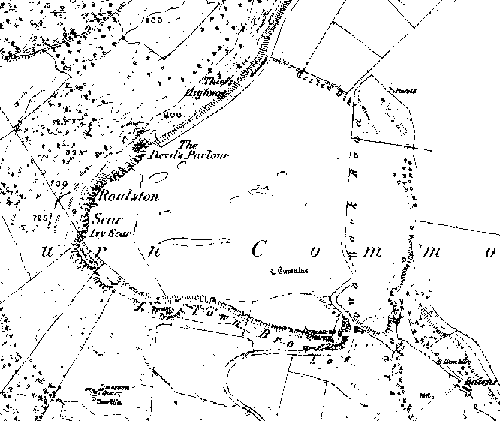
Roulston Scar, from Old-Maps.
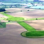
There are a number of good sources of maps, online, there is www.old-maps.co.uk, which has the entire OS 1850’s series of large resolution 6 inch maps, these show up all sorts of Earthworks that archaeologists are in some places just starting to pick up on, also, in general this map has the best naming of fields and given it’s age shows a significantly older landscape than is shown in modern maps. In a savage fight back of new agaist old Google Maps throw their weight behind a tunnel down set of OS maps, which ultimately go down to 1:5000 scale maps, but the best map is at 1:50,000 scale, which is based on the OS Landranger map series, the 1:25,000 map is unfortunately not based on the current Explorer series, but is instead a blow up of the 1:50,000 scale map. To make uo for this, those people at multimap have built in and air photo facility, which is best viewed at 1:25,000 scale but can give some very good shots at 1:10,000 scale or better. Just show how good multimap can be, the first site I viewed using it tonight brought up the very good view of Maiden Castle, Reeth shown below.
Maiden Castle, Reeth, Satellite.
There are also lots of other maps available online, most of them, unfortunately, are either too general to be of real use, or are hidden deep in an elusive webpage. So it’s off to the library next, in Yorkshire, good maps started around 1610 with the John Stead Maps, these, remarkably are available in many places (including Old Mother Shiptons Cave, Knaresborough) for around £3.00, well worth looking out for. Possibly the best antiquarian map of Yorkshire is Warburtons map of 1720. Warburton took trouble to note Roman roads, many have since disappeared and in some cases are no longer recognized. For these maps plus more recent maps or older, more specific estate maps try the local library, then the county or larger libraries, if you are lucky they will allow photocopying. Other places to look include national organizations such as the Bodlian of the British Library, however access to maps without paying at this level can be very difficult and time consuming. Other maps to have to hand include the Ordnance Survey Explorer and Landranger Series, As well as their maps of Ancient and Roman Britain.
Maps – What am I looking for?
An important aspect of any ancient site is what can be seen around it. On the horizon, key features will have served as way markers for routes to other settlements and industrial, trade and religious meeting places, simply by looking at a map, a much broader picture of the environment of a particular site can be seen, often glimpses of the more ancient Iron Age can be determined, by interpreting modern indicators of activity. Recognizing the important features is a combination of several skills, which are covered in this guide.
One way of trying to understand a sites importance, is it’s relationship to sources of trade and industry – proximity to a source of natural resources or a trade route away from that site gives a settlements occupant access to both additional sources of wealth and long distance communications, in a non literate society such as that of the Celts, regular sources of good information will have been of great value, it is likely that a verbal trade was practiced, in some cases this verbal trade will have been of more value than the goods traded.
Mapping Techniques – [su_button url=”https://brigantesnation.com/guide-los-analysis”]Line of Site Analysis[/su_button]
Internet Research – Online Forums
Many professional and amateur archaeologists alike have become attracted to the Internet as a means of exchanging information and views. Most forums come in two guises – The email forum operates via email, with members sending mail’s to a group address, which copies the mail to everyone. The hosted forum uses a webpage which is accessed online and shows a list of discussions which may be read. Most archaeology forums are membership only, and many ban discussion on religious groups of likely to get abusive.
Newbies to the world of on-line archaeology tend to stick to chat rooms such as the Time Team Forum, or the BBC’s Talking history pages, however, discussion on these boards can often be program centric and may be of limited use. Other, more dedicated forums, such as Talking History or The Modern Antiquarian can often be a good source of information. Some forums have significant and searchable archives, which should be consulted.
Forum etiquette
The newbie should be advised that most, if not all online forums are run by a few dedicated moderators whose function is solely to ensure things do not get out of hand. If you ask a question you should not expect an answer, and should be patient, it is a good idea to “listen in” for a while to get a feel for a forum before raising a question. From time to time, even the most communicative of forums seems to go to sleep, with little information getting exchanged.
Initial Interpretation
At this stage in the research, often all that is available are a few maps plus a couple of spurious mentions in other documents, however, there are ways to analyze some of the information to hand at this stage in order to confirm initial thoughts and stimulate further research without actually visiting the site. Often there are clues in the names of places. Sometimes field boundaries can be seen to continue earlier earthworks.
Place Names
Often the names of places can provide additional clues to the antiquity of a site. Names of places have originated or been modified by subsequent newcomers to Britain, but often the name itself gives away clues to even greater antiquity. For example, in Brigantia, the name Brough seems synonymous with Roman forts. Similarly the word Borough or derivatives such as Aldborough indicate a Roman presence at that location.
Studying Field-Names
Ruth E. Richardson – Council for Independent Archaeology (CIA)
Field-names may include the oldest documentary and verbal information available to us. Although most names were actually first written down in the 18th and l9th centuries, field-names are mentioned sufficiently often in manorial and estate records to show that they were in common usage. An early famous example is in the peace treaty of 1215 between King John and the barons, later known as Magna Carta, which was signed “in the meadow that is called Runnymede”, Old English for council or assembly island. In Much Marcle in Herefordshire a group of 13th and 14th century deeds has survived. They are sale transactions for the exchange of strips in the Common Fields to allow blocks of holdings to be formed. An example of a field-name on the 1839 tithe map is Normandy and this can be traced back to 1308 through these deeds. Interestingly, one deed of 1491 actually names a strip in this field, showing that at least some strips had their own independent names within the larger named field. Another example is the tithe map name of Lying Down field which can be traced back to La Lynde, or Lyndende, which shows that it is derived from the word for lime trees. Limes, even more than oaks are indicators of ancient woodland.
Field-names provide a simple and practical method for referring to a piece of land. This is only necessary if the person involved is recording information about it, or discussing it with another person. If you are working in your field you do not need to name it! It is probable that every used piece of land has, or had, a field-name because farmers, probably from as far back as the Neolithic, found this useful. A farmer could leave word of where he could be found if needed. He could easily note which fields had been worked according to agricultural requirements. The field-names chosen would be something relevant to the field. The majority concern the quality of the soil, the shape of the field, the prevalent vegetation and agricultural use. They are a way of recording difficulties about the soil and the state of the field in the days before computerised records. However, an important result of such practices was to provide a way of passing information to future generations of farmers – a stony field could break the plough – and this was especially important in the past when young adults could die suddenly.
However, for us, field-names can demonstrate changes in the landscape and they allow features to be traced. A minority of names preserves the history of the fields giving ownership names, some of which can be confirmed from other sources, or by recording significant events, which may be less easy to verify.
Two notes of caution need to be mentioned. Firstly, it is likely some fields have become subdivided. If a name was given to a particular field it is always possible that it was perpetuated attached to only a portion of the original. If the name refers to a condition like soil, or a survival like a Roman road, or indeed anything peculiar to what was once a part of a field, then it is a possibility that the name survived attached to the ‘wrong’ portion. This is why it is always useful to examine an area around a field-name and not just one modern field. Secondly, there is absolutely no certainty that each and every instance of a fieldname will have the same derivation, as some may come from other sources such as personal names. Care is needed as a lot of rubbish has discredited fieldname use in the past when people have jumped to conclusions concerning meanings. The earliest reference needs to be found if possible. Although the original spelling of a name may be difficult to determine, deductions, with a statistical probability of a meaning, can be made by examining occurrence over a wide area.
However, such reservations do not matter if a significant field- name is considered to be only the start of an investigation. It shows a site is worth examining and one needs to remember that the reason for a particular fieldname must always predate its first use for that particular field. Therefore, the age of the fieldname is crucial.
Archaeological field-names are relatively few but are an archaeological tool to be used with evidence gained from fieldwalking, geophysical surveying and aerial photography. It was in order to demonstrate their usefulness that a group of the members of the Woolhope Naturalists’ Field Club in Herefordshire decided to publish the tithe maps and the field-names for the whole county.
The tithe survey resulted from the Tithe Commutation Act of 1836 and the Herefordshire survey was produced between 1838-1846, Some counties already had enclosure maps so did not warrant a full survey. Herefordshire had few enclosure awards though the Woolhope Group used these to supplement the tithe survey where necessary. Indeed, as the field-names for every parish have now been published, Herefordshire has the first complete coverage readily available for any county in Britain. All involved were volunteers and the organization followed a set procedure, which I would be happy to describe in detail if any of you would like to ask me afterwards. Tithe maps are so large that comparing more than two is impossible. Therefore, the maps were redrawn to a uniform, and reduced, scale of 6 ins: 1 mile by a cartographer. This allows comparisons between parishes, and with ordnance survey maps, so the actual fields can be located.
Publication began in 1987 with nineteen parishes, more being added annually, usually twice a year, until all were published in the autumn of 1993.
number of people involved – 118 (collecting/publishing)
number of fields copied – 125,367
number of parishes/townships – 260, in 222 booklets
cost – from £1.25 to £4.50 per parish (total set £542)
number of booklets sold – 9,000+
They were bought by schools, libraries, the general public, the English Place-Name Society, the local Archaeological Unit and more. Requests even came from Australia, Europe and America – from people whose families used to know certain parishes. In this way more information was obtained, sometimes just about one field. In order to further publicize the potential of field-names to a wider audience the Woolhope Group entered the 1994 British Archaeological Awards and were thrilled to win. An accompanying cheque from the Robert Kiln Trust is being used as core funding for The Millennium Air Survey of Herefordshire and these aerial photographs, taken by Chris Musson, can be compared with known sites and with field-names.
The first part of The Herefordshire Field-Name Survey was simply to make the parishes, and field-names, available. The second, on- going, part is to record field-names from other sources such as wills, deeds, sales, documents, leases, etc. The information is published regularly in the Woolhope’ Club transactions. People are asked to provide the field-name found /its date /source /location using the tithe number.
This information is required whether the field-name is the same as, or different from, the tithe field-name as only in this way can the ages of the field-names be properly assessed. In addition, several of our group have analysed particular field- names and the full results will be in the next, 1996, edition of the Woolhope Club Transactions.
Field-names provide extremely varied information about the landscape and so can be of use in many disciplines. There is still an incredible amount of information to be learned from them. Fieldnames are a direct link with the past and are an invaluable resource. It is research open to anyone and I do urge you to use them.
Using Air-photos
Jim Pickering – CIA
It is more than 70 years since archaeologists realized that photographs taken from the air provided a new source of information on archaeological sites. Information accumulated from this source is now so immense and varied that its volume is a barrier to its incorporation into the archaeological ethos both locally and nationally. Its development in Europe raises the same problems.
Initially, new archaeological information was obtained from routine air photographs taken for other than archaeological purposes. Inclusion of archaeological information was accidental. This source was made obsolete by the prospecting and recording techniques developed by the late Major Allen in the 1930s. Whilst very limited information can occasionally and unpredictably be obtained from routine photographs, the techniques of Major Allen provide the main source of new information. Unfortunately, use of the results has preceded an understanding of the factors involved.
The development of aerial archaeology as a specific subject has taken place on the periphery of archaeology rather than as an integral part of its research. To some extent this has been inevitable because training and experience are required that are not a part of archaeological studies.
Most archaeologists know that the most prolific source of new information comes from the patterns provided by small variations of growth stages of the deeper rooting annual crops, that may be visible for only a few days at infrequent annual intervals. A photograph is merely the easiest and quickest way of recording an observation. Some of the crop mark patterns are only visible from limited angles and some provide the most information from a critical angle that can only be decided by the pilot. Many casual attempts have been made by archaeologists to carry out surveys from the air, but lack of experience, perseverance and resources doomed most of them to disappointing results or total failure.
Distribution of the information obtained in this way has always been a major difficulty. Archaeological field work is mainly directed to specific sites, specific problems, specific periods and local interests. To exploit crop marks, it is necessary to carry out air archaeology in those areas where crop marks have become visible and these do not often coincide with current archaeological activity in any one year. Nor is there a sound reason to start a programme of air archaeology for an area unless it is to be systematically applied for decades. Without this, only a few known hardy annuals will be repeatedly recorded.
Interpreting the information on air photographs has made little progress in the last 50 years. The patterns of crop marks that seem similar to the ground plans of excavated sites can be plotted onto maps to provide a catalogue to information on file, but this only provides an archaeological explanation of some. It will for instance identify Roman forts, or some Roman villas, but neither excavation nor plotting on maps have explained pit alignments. There are many crop mark patterns for which there are no excavated parallels.


