Identifying and Interpreting Field Drainage Gullies
When conducting a field walk, it’s essential to be able to identify and interpret the various types of features that appear on the landscape. One common feature you might encounter is a drainage gully—a shallow ditch or channel, often running across fields, which is used to direct water away from certain areas. While their purpose is apparently straightforward, their identification and dating can sometimes be tricky, especially given how many forms of field drainage have existed throughout history.
What is a Drainage Gully?
A drainage gully is typically a shallow ditch that is designed to improve the drainage of the land. These features are especially common in fields with boggy or poorly-drained soils, where water needs to be diverted to improve growing conditions or allow easier access for farming and livestock. Drainage gullies can often be seen running parallel across a field, either in a single line or multiple lines, depending on the landscape’s needs.
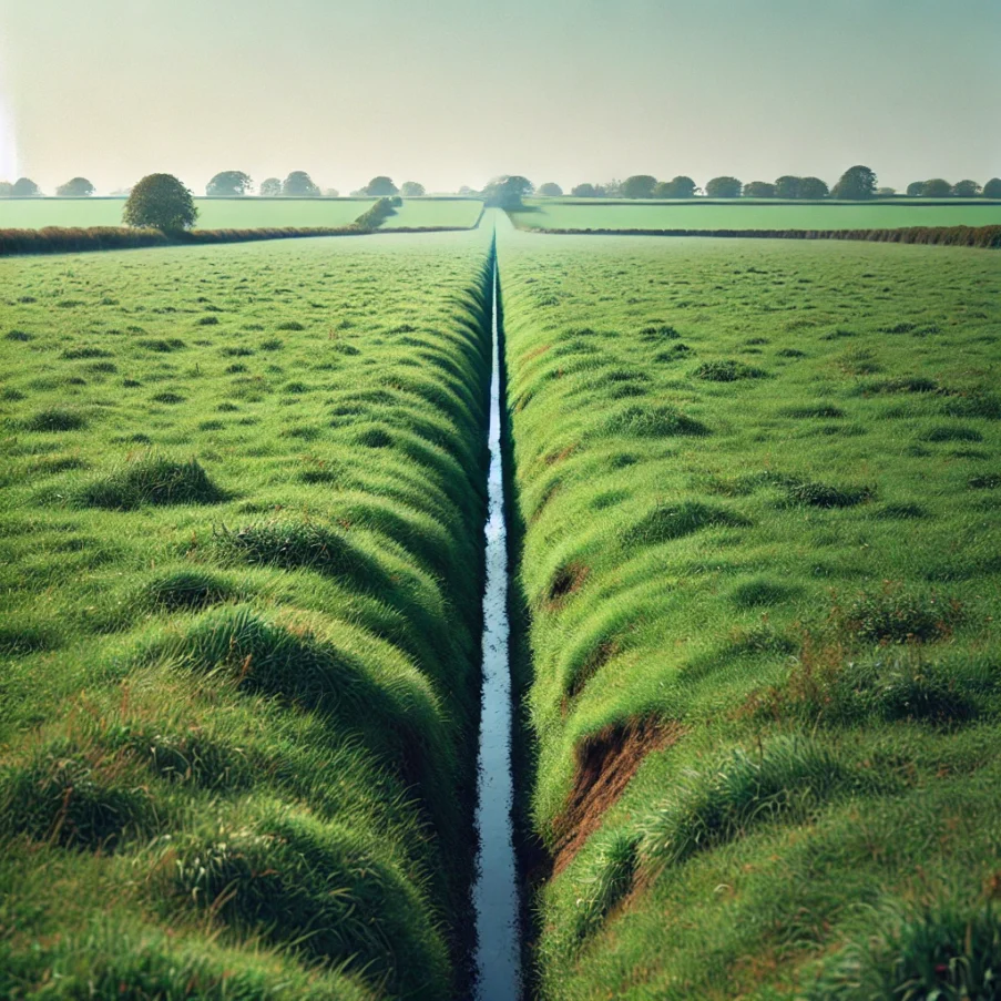
In our image, you can see a typical, but basic recreation of a drainage gully, with its u-shaped profile about 3 feet wide and 2 feet deep. The gully’s edges are often marked by slightly darker soil, where water has compacted the earth over time. These gullies can often appear as straight lines, which may be indicative of more modern drainage work, as machinery tends to favour straight lines when digging ditches. However, this is not a fool proof indicator of the gully’s age or origin.
The Challenge of Dating Drainage Gullies
Dating drainage gullies can be particularly challenging. Unlike structures like Roman roads or Iron Age hillforts, which can often be identified by distinctive markers or construction techniques, drainage gullies are less likely to have overt signs of their age.
Straight Lines: One of the most common assumptions when trying to date a drainage gully is to look at how straight the line of the gully is. A very straight line suggests that the feature was most likely dug using modern machinery, which tends to follow exact lines. This is often the case for features visible in fields with modern ploughing and drainage systems.
Ancient Drainage: However, the presence of straight lines in ancient drainage systems should not be dismissed outright. Even Roman and Iron Age engineers were capable of creating straight lines, and the idea that these ancient peoples lacked the technology to create precision-based features is outdated. Evidence from Roman roads, aqueducts, and even ancient drainage systems shows that straight-line construction was a hallmark of their civil engineering skills. Therefore, when dealing with ancient field drainage, you must also consider other factors, such as location, site context, and any associated artifacts found nearby.
Modern Features: In general, the modern drainage gullies are more likely to be machine-cut, with very regular profiles and straight lines. In areas where agriculture is heavily mechanized, such as lowland areas or regions with significant fieldworks, it is more probable that the gullies date to the 20th century or later.
Drainage Gullies as Boundary Markers
Another important aspect of drainage gullies is their potential role as boundary markers. In many cases, a drainage gully may have been deliberately placed to not only manage water flow but also to mark the limits of land ownership or field boundaries. This is especially true in areas where land division was a prominent feature of ancient agricultural landscapes.
- Roman and Iron Age: During the Roman and Iron Age periods, boundaries were a significant aspect of land management. It is not uncommon to find evidence of both drainage systems and boundary markers in the same regions, particularly in agricultural zones. A drainage gully could easily have served as a practical feature while also denoting the limits of a farm, estate, or tribal territory.
- Modern Boundaries: In more recent times, drainage gullies continue to play an important role in defining boundaries, especially in areas where they may have been laid out during land reclamation projects in the 18th or 19th centuries.
Interpretation of Drainage Features in Fieldwalking
When you encounter a drainage gully during a field walk, here are a few important steps to help you interpret its possible origin:
Examine the Line: Is the line of the gully straight or curving? A straight line may suggest modern machinery, but also consider the possibility of ancient engineering.
Check the Depth and Shape: The profile of the gully can tell you a lot. Modern drainage ditches are often V-shaped or U-shaped, but older features may have a more irregular profile.
Look for Associated Features: Are there other field markers, such as stone walls, boundary stones, or ancient tracks, near the gully? The presence of these could indicate a much older origin.
Artifact Evidence: If you find pottery, tools, or other artifacts near the drainage feature, this can help date the site and provide further context to your interpretation.
Conclusion: Recognizing the Importance of Drainage Gullies
Drainage gullies are often overlooked, but they can be key to understanding the landscape’s history, the agricultural practices of past peoples, and even territorial boundaries. While modern features are more likely to have straight lines, it’s crucial not to dismiss the possibility of ancient drainage systems that were engineered with precision.
When walking a field, take time to recognize these features not just as evidence of agricultural management, but as markers of how landscapes were shaped by both ancient and modern practices. As you collect evidence, always approach with an open mind and an eye for context, ensuring that every feature—whether ancient or modern—can contribute to a deeper understanding of the past.


