

A gazetteer of probable prehistoric mounds, cairns and boundary earthworks in Coverdale. It is not complete and is still being researched.
Jun 27
A gazetteer of probable prehistoric mounds, cairns and boundary earthworks in Coverdale. It is not complete and is still being researched.
Jun 15
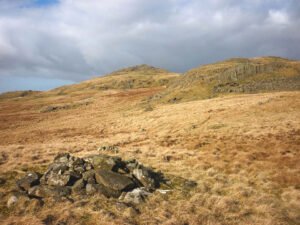
On every late-Victorian and early-20th-century OS sheet the surveyors marked any conspicuous heap of stones they could not instantly classify as a tumulus, beacon, trig-point or boundary stone with the catch-all term “Pile of Stones.”
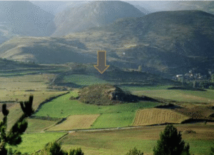
Montlleó sits at 1,144 m a.s.l. on a low knoll in the high, east–west Cerdanya valley of the eastern Pyrenees, a natural corridor between the Bay of Biscay and the Gulf of Lion. Excavated since 2000, the open-air site preserves a 23,000 – 17,000 cal BP occupation sequence that spans the harshest part of the Last Glacial Maximum (LGM) through early deglaciation. Because mountain ice in the Pyrenees retreated earlier than the global LGM, Montlleó shows that hunter-gatherers could exploit altitudes that were once thought permafrost-bound.
Jan 23

Guide – Archaeological Terms Glossary of Archaeological Terms Acheulian Later stages of Lower Palaeolithic culture defined by their particularly fine hand axes. Aeolian Deposited Read more Historic Publications Historic Publications Tacitus Tacitus grew up during a the reign of Nero, and may have been a teenager when Nero Read more Southern Roman Forts Map …
Jan 23

Fieldwalking is one of the simplest and most accessible forms of archaeological survey. It involves systematically walking over a landscape, searching for surface artifacts—such as pottery, stone tools, and animal bones—that may have been left behind by past human activity. This activity can offer valuable insights into ancient settlements, trade routes, and other key elements of the past.
Jan 23

Photography is an essential tool in archaeology, not only for documenting finds but also for interpreting and preserving evidence. However, images often require some level of post-processing to enhance clarity, correct lighting issues, or reveal details that may not be immediately visible. Image manipulation software plays a crucial role in this process, allowing archaeologists to adjust images while maintaining the integrity of the data.
Jan 23

The Thornborough Henges are located within a distinctive and complex landscape that has been shaped over millennia by a combination of glacial forces, river systems, and post-glacial climatic changes. The landscape of Thornborough is defined by its geological foundations and the dynamic processes that transformed the area long before human presence.
Jan 23

When it comes to archaeological photography, capturing the best possible images, whether of small artifacts or large sites, requires thoughtful consideration of the camera’s capabilities. The right camera allows you to document sites and findings clearly, effectively, and with long-lasting quality.
Jan 23

When photographing archaeological sites, the key to a successful shot lies not just in the technology you use but in how you frame the scene, manage lighting, and anticipate the environment. The art of capturing the best possible image is a blend of technical understanding and creative intuition.
Jan 23
Photography has long been an essential tool in archaeology, providing a visual record of sites, finds, and features. In the context of archaeological research, photos do more than simply document—they offer crucial evidence that can be revisited, analysed, and shared.
 NLS Map Explorer
 Google Earth
 Google Maps
 Lidar Finder
 TMA
TMA
 Megalithic Portal
 Yorkshire Arch. Air Mapping
 ADS
ADS
 Brigantian Adventure FB Group
Stone Bothering FB Group
Stone Faces FB Group
Brigantian Adventure FB Group
Stone Bothering FB Group
Stone Faces FB Group
 Heritage Gateway
 ARCHI® MAPS: UK
 Atlas of Hillforts
 Portable Antiquities
 British History Online
Brigantes Nation FB Group
British History Online
Brigantes Nation FB Group

