These are raised platforms created first and foremost for cult, procession, assembly or conversion—not for fortification or routine boundary-making. They Read more
Synthetic-Aperture Radar (SAR) already relies on Doppler shifts: echoes from scatterers in a side-looking radar beam have slightly different frequencies Read more
Why so many “Pile of Stones” labels appear on the Ordnance Survey
On every late-Victorian and early-20th-century OS sheet the surveyors marked any conspicuous heap of stones they could not instantly classify as a tumulus, beacon, trig-point or boundary stone with the catch-all term “Pile of Stones.” The words tell us that something big enough to map was there, but say nothing about age or purpose. Up on the Limestone hills one label might hide a prehistoric burial Cairn; the next, only a shepherd’s guide-pile from fifty years ago.
Below are the most common reasons such heaps were made:
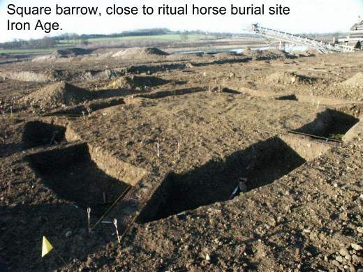
Prehistoric burial or ritual cairns
Usually on a skyline, often 10 m or more across.
Bronze-Age people raised stone mounds over graves or as territory markers. These cairns weather down but still sit very broad and low; their edges merge with the turf. If you see a ring of kerb-stones or a slight hollow where antiquarians dug, you are probably looking at a true barrow rather than a later pile. Examples: Penhill Beacon cairn, West Scrafton twin barrows.
Boundary-marker cairns
Often smaller (3–7 m), placed exactly on a ridge crest or parish line.
Medieval and early-modern township shepherds built neat heaps to mark summer-pasture limits. Where two or three align, as on Little Whernside / Great Hunters Stone, they form a visual gateway. These cairns seldom have kerbs or central pits and often sit right beside later drystone walls or boundary stones.
Guide cairns for travellers
Shoestring piles beside old moor lanes.
Before signposts, a tall cairn every few hundred metres kept Pack-horse trains on route in mist or snow. The Hunter’s Stone in Coverdale guide-pillar represents the formal end of such a cairn line on the high road over Bycliffe Bank. Roadside cairns rarely exceed two metres diameter and look “perched” on the edge of the track rather than bedded into the turf.
Clearance heaps and “scree-pikes”
Low, ragged, and sitting in or beside former fields.
Where the dale-bottom soils were full of limestone slabs, farmers dragged stones to the field edge and tipped them into rough cones. These mounds usually lie well below the 300-metre contour and beside medieval ridge-and-furrow or strip lynchets (for instance, on the terraces above Caldbergh). Digging into one reveals a careless mix of soil, stones and pottery sherds.
How to decide which is which when you meet a “Pile of Stones”
Check the position
Skyline or watershed? Likely ritual or boundary.
Field corner or lynchet lip? Probably clearance.
Beside a straight track? Often a guide-cairn or butt.
Look for construction clues
Kerb-ring, laid courses, or a deliberate capping platform point to prehistoric work.
Haphazard tippings mixed with top-soil suggest clearance.
A squared-off front or recess cut into the slope usually means a grouse-butt.
See what the map edges do
If a parish or township line runs through the cairn, the heap had boundary value when the tithe maps were drawn (early 1800s). That does not prove it is prehistoric, but hints at long-standing respect.
Look for artefacts.
Flint flakes, Bronze-Age pottery or hammer-scale on the surface push you earlier. Clay-pipe stems, glass and cartridges push you later.
A “Pile of Stones” on the OS is an invitation to look closer. On the high Coverdale ridges most prove to be either Bronze-Age ritual cairns or medieval/post-medieval boundary heaps; those near tracks and on shooting moors often resolve into Victorian grouse butts. Noting their size, setting and build will usually tell you which story you are looking at.
A Probable Neolithic flint piece of debitage possbily intended to be a blade.The fragment is made from a tertiary flake of semi-glossy light grey flint with slightly darker grey patches. It is sub-triangular in plan [...]
A very worn and chipped Roman copper alloy radiate of uncertain emperor dating to the period AD 260-275 (Reece period 13). Unclear reverse type depicting figure standing left. Unclear mint. [...]
A heavily worn Medieval silver 'short cross' cut farthing of an uncertain monarch, Henry II to Henry III dating to the period c.1180-1247. Not further defined.Length: 9.6mm; width: 9.4mm; thickness: 0.5mm; weight: 0.4g. [...]
Silver medieval penny of an uncertain ruler, probably Henry V to Henry VI (1413 - 1461) minted at York. The coin is in poor condition, is 16mm in diameter and weighs 1.00g. [...]
A Roman copper-alloy radiate of Tetricus I/II dating to circa AD 271-274 (Reece Period 13). PAX AVG reverse type depicting Pax standing left holding branch and vertical sceptre. Gallic Mint I. [...]
A Roman copper-alloy nummus of Magnentius or Decentius dating to AD 250-253 (Reece Period 18). VICTORIAE DD NN AVG ET CAE reverse type depicting two Victories holding wreath inscribed [VOT/V/MVLT/X]. Mint of Trier. [...]
A Roman silver denarius of Antoninus Pius (AD 138-161) dating to AD 154-155 (Reece Period 7). COS [IIII] reverse type depicting Fortuna, draped, standing right, holding rudder, vertical on globe, in right hand and cornucopiae, with tip [...]
A Roman copper-alloy barbarous radiate copying a coin of Victorinus (AD 268-270) dating to circa AD 275-285 (Reece Period 14). Copying PAX AVG reverse type depicting Pax standing left holding branch and transverse sceptre. Unclear [...]
A Roman copper-alloy radiate of Carausius (AD 286-293) dating to circa AD 286-293 (Reece Period 14). PAX AVG reverse type depicting Pax standing holding branch and vertical sceptre. Unclear mint. [...]
A Roman copper alloy radiate of Tetricus II (AD 272-274) dating to circa AD 272-274 (Reece Period 1). [SPES AVG] reverse type depicting Spes walking left holding branch and raising hem of robe. Unclear mint. [...]
A free-standing pierced stone weight of uncertain age, but probably dating to the Post Medieval period.The object is sub-square in plan and rectangular in cross section. Its sides appear to have been sanded to give [...]
A Roman copper-alloy barbarous radiate copying a coin of Divus Claudius II (AD 270-271) dating to circa AD 275-285 (Reece Period 14). Copying CONSECRATIO reverse type depicting altar with crescent. Unclear prototype mint. [...]
A free-standing cast lead conical 12.43g weight of uncertain age, but probably dating to the Post Medieval period.It has a sub-circular base with concave tapering sides up to a slightly flattened apex. A circular hole runs through [...]
A free-standing cast lead conical 20.79g weight of uncertain age, but probably dating to the Post Medieval period.It has a sub-circular base with tapering sides up to a slightly flattened apex. A circular hole runs through the [...]
A clipped Post Medieval silver halfgroat of James I (AD 1603-1625). First coinage, dating to AD 1603-1604. Mint of London. North (1991: 144) No. 2076, thistle mintmark. [...]
A very worn Post Medieval silver three pence of Elizabeth I (AD 1558-1603) second coinage dating to AD 1561-1582. Mint of London. Unclear initial mark. North (1991: 135) no. 1998. [...]


")


