Notice: Function WP_Scripts::add was called incorrectly. The script with the handle "datatables-responsive" was enqueued with dependencies that are not registered: datatables. Please see Debugging in WordPress for more information. (This message was added in version 6.9.1.) in /home/u621095157/domains/brigantesnation.com/public_html/wp-includes/functions.php on line 6131
Archaeologists now recognise a true Neolithic henge lying immediately south-west of Moulton village, roughly midway between the Swale and Dere Read more
The Earthworks at Manor Grange in Wensleydale are a testament to the rich historical tapestry of the Yorkshire Dales.
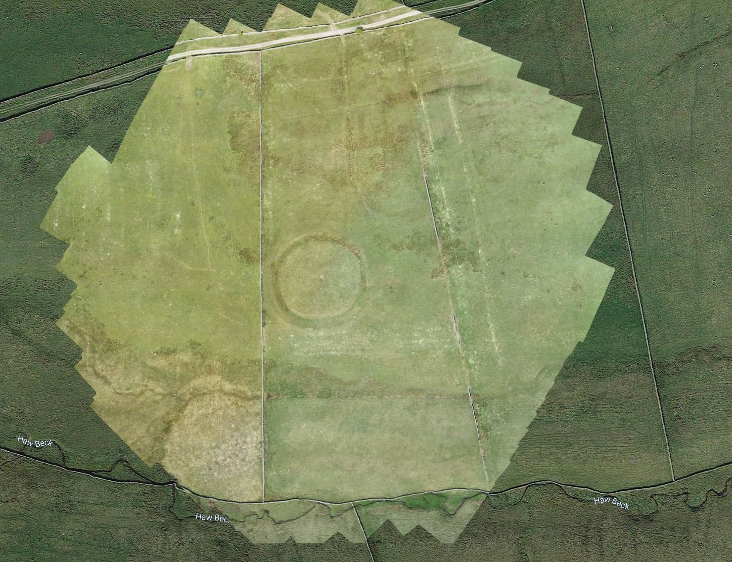
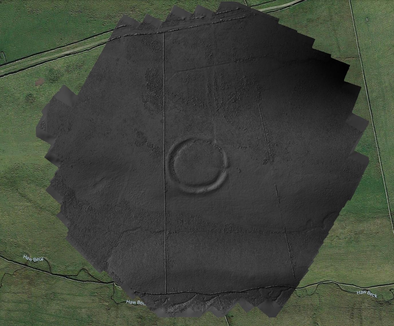
Castle Dykes Henge, near Aysgarth
Castle Dykes Henge lies about 2 km southwest of Aysgarth in Wensleydale, North Yorkshire, at National Grid reference SD 98231 87289 and c. 305 m above ordnance datum (researchgate.net, en.wikipedia.org). It occupies a gentle ridge top between the villages of Aysgarth and Thornton Rust, overlooking Bishopdale and the River Ure valley.
Monument Description
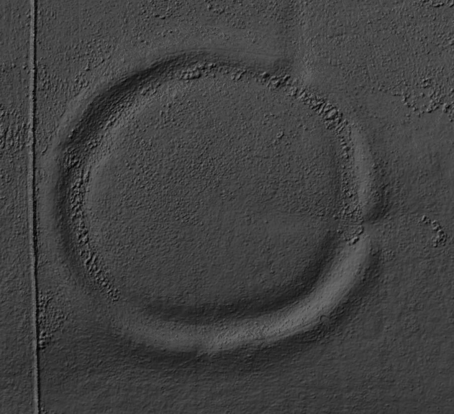
This is a Class I henge: an almost circular earthen bank c. 80 m in internal diameter, with a continuous internal ditch, and a single entrance on the east side (en.wikipedia.org). The bank survives up to 1.5 m high in places, and the ditch up to 3 m deep. Early 20th-century reports (1908) noted its intact form, and recent LiDAR-based surveys have confirmed its classic henge profile with minimal later disturbance (megalithic.co.uk).
Archaeological Investigations & Dating
No extensive Victorian-era excavations are documented, but in 2015–16 Alex Gibson’s team carried out a large geophysical survey and cored the waterlogged ditch for environmental sampling (royalarchinst.org). Two radiocarbon dates from short-lived hazel roundwood in the ditch fill are statistically identical and fall firmly in the Iron Age (c. 750–400 cal BC) (royalarchinst.org, static.cambridge.org). A smaller charcoal fragment gave a more precise date of c. 562–419 cal BC (66.8% probability) (static.cambridge.org).
Environmental Evidence & Function
Pollen and plant-macro remains show hedged grassland with signs of cereal cultivation, while aquatic plants and beetle remains attest to a partly waterlogged ditch (royalarchinst.org). The presence of dung-associated beetles and nutrient-enriched weeds (nettles, chickweed) suggests livestock grazing nearby. Geophysical data also revealed concentric pits—interpreted as timber-built roundhouses—both within the enclosure and just outside, implying a short-term or seasonal gathering place rather than a permanently occupied settlement (cambridge.org).
The sun beat down
Commentary from Tony Hunt of YAAM. Written prior to the henge being dated to the Iron Age.
Castle dykes it is a small class one henge, only 90m across, perched on the high ground up in the North Yorkshire dales.
Getting there
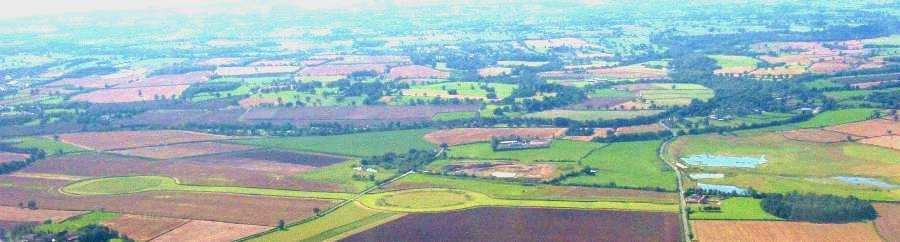
Take the Leyburn road, past Castle Bolton, past the increasingly grey stoned villages and towns, follow the screaming motorcycles and the wobbling cyclists. Keep going: further up, further into North Yorkshire until you come to Aysgarth: Home to the famous waterfalls, with its rash of tourists, walkers and sightseers. Then turn off the increasingly narrow road, signposted Thornton Rust.
Disappointment crept over the team
At this point a certain disappointment crept over the team, as the tarmacked road was immediately replaced by what can only be called a track, and a rough one at that. Rather upsettingly, it was quickly clear that walking, drone kit or not, was the only option.
The sun beat down, the bags dragged, and the stones underfoot refused to cooperate, but duty called, so the
The Bright Orange Mini Mapping Machine was dutifully abandoned, and the team began to walk.
Actually, this was, after the shock had worn off, a not unpleasant experience. All around us was the stunning beauty of the North Yorkshire Dales: the only sounds the plaintive sheep, curlews screaming, and the buffeting of the brisk wind.
Bones of the ground
The countryside was green and bright, but the bones of the ground showed through the rough thin soil: grey walls hemmed us in, the stones covered with blood-red lichen, the iron gates rusty and raw pink with corrosion. A series of natural springs ran across the path, the waters running secretly into the verges: they have washed the soils from the path, leaving them stony, sharp and bleak.
The track ran fairly flat, hemmed in by rough stone walls until, after 2 miles, it suddenly rose, climbing steeply, forcing us to push harder until suddenly we were there.
Bleakness and the loneliness of the setting
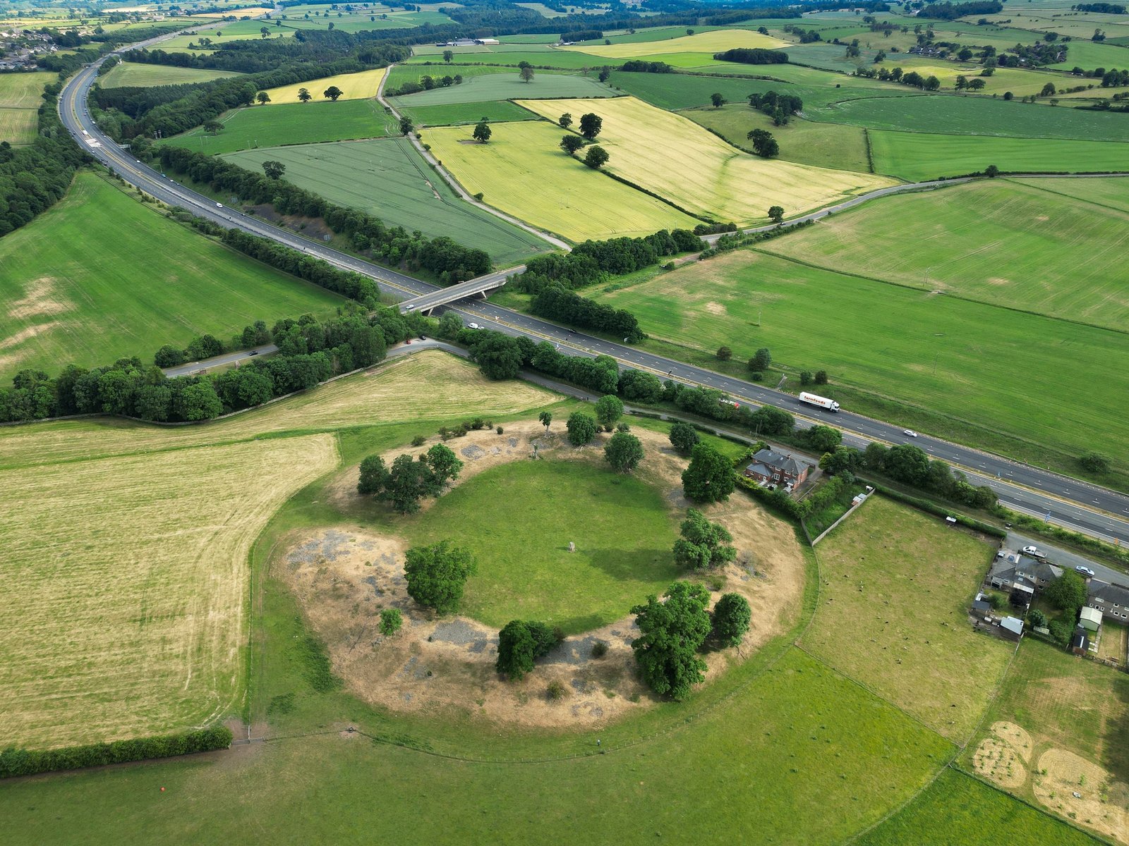
The land around the henge is a flat platform. The Earthwork itself is 200 yards from the path, along a damp field boundary, that rises at the last second to a flat area, tilted to the south-east – towards the rising sun on the winter’s equinox.
The henge is a typical shape: circular, 100m across, consisting of bank, ditch, flat central platform, then ditch/bank again.
The ditches remain about a metre deep: the banks similar. We sat and quietly gazed, absorbed by the bleakness and the loneliness of the setting.
The most prominent and magnificent mountain in sight
There is one entrance into the central area: again facing South east, facing the great peak, off in the distance, the most prominent and magnificent mountain in sight. And to one side of the bridge across the ditch and bank is a large stone, now 90% buried in the bank, to the right of the entrance. Was there once a twin guarding the other side? Who knows? Certainly it would be easy to believe that this 4000-year-old monument had twin grim stones stood each side of the entrance way to welcome the midwinter sun and frame it for the frozen watchers.
Why did our ancestors build this great earth temple out here? There is no clue. No apparent reason. But all we can say is that the amount of work for a primitive society with no metals and no machinery is simply monumental, and therefore they did not build it on a Whim, and neither did they build it quickly. This is the work of an organised society committed to achieving a group objective.
Whatever the reason, it was clearly good enough for them. And therefore good enough for us. We took our picture’s and quietly left the henge to the screaming birds, the sheep, and the lonely sky.
Civilisation, our garden and wine is less than an hour away and yet, for an hour or so sitting on these earthen banks, it seemed a million miles and 4000 years away.
References for further reading
Gibson, A. “Survey and Sampling at the Castle Dykes Iron Age ‘Henge’…” Antiquaries Journal 99 (2019).


 Bleakness and the loneliness of the setting


