Hutton Moor Henge, North Yorkshire


Hutton Moor Henge, North Yorkshire.

Hutton Moor Henge, Photo by Ray Selkirk


The Kingdom of Venutius

The Kingdom of Venutius – Brigantia – AD 69

“Inspired by these differences between the Roman forces and by the many rumours of civil was that reached them, the britons plucked up courage under the leadership of Venutius, who, in addition to his own natural spirit and hatred of the Roman name, was fired by his personal resentment towards queen Cartimandua. She was ruler over the Brigantes, having the influence that belongs to high birth, and she had later strengthened her power when she was credited weith having captured king Caratacus by treachery and so furnished an adornment for the triumph of Claudius Caesar. From this came her wealth and the wanton spirit which success breeds. She grew to despise her husband Venutius, and took as her consort his squire Vellocatus, whom she admitted to share the throne with her. Her house was at once shaken by this scandalous act. Her husband was favoured by the sentiments of all the citzens; the adulterer was supported by the queens pashion for him and by her savage spirit. So Venutius, calling in aid from outside and at the same time assisted by a revolt of the Brigantes themselves, put Cartimanua into an extremely dangerous position. Then she asked the Romans for protection, and some of our auxiliary troops, cavalry and infantry, after meeting with indifferent success in a number of engagements, finally succeeded in snatching the queen from danger. The throne was left to Venutius, the war to us.” Tacitus (Histories iii, 45).

Tacitus, Roman historian of the 1st Century AD. has provided us with most of the written history of the Brigantes at the time of the Roman conquest. The above text, written about a time when Nero had fallen and Rome endured several emporers in one year – AD69 clearly illustrates the date when Venutius finally became king of all Brigantia.

The few references thast we have from Tacitus and other Roman authors provide a dim glimpse of the events that surrounded the Roman conquest of Brigantia, yet the story is a tantalising one, a tail of royal adultery, power struggles, revolution and conquest. Brigantesnation.com began life as an experiment to see if it was possible to recreate more accurately this lost history of Brigantia, to see if recent developments in archaeology could help fill the gaps left by those ancient authors.

Firstly, we need to understand the gaps – [su_button url=”https://brigantesnation.com/brigantia-the-ancient-sources”]Source Documents[/su_button]

This map outlines a postulated border for the Brigantia of Venutius in AD69. By this time Venutius had ousted Cartimandua from her throne and was King of Brigantia. A small area to the south shows the territory already lost to Roman rule.

In order to verify this border, this research attempts to locate the defences that Venutius set up in anticipation of the Roman advance.

The map has click zones which identify major military sites available to Venutius, although many have date yet to be proven, most can be demonstrated to be pre-Roman, and therefore available for use.

The southern border, shown in red, complies with the [su_button url=”https://brigantesnation.com/the-gallus-frontier-brigantia-against-the-romans”]Roman frontier[/su_button], as implied by fort locations and other dating evidence.

Devil's Arrows Standing Stones  Roman border area AD69 Boltby Scar Hill Fort Roman Rig - Venutius' southeastern border Ingleborough Hill Fort Tor Dyke - Defense Mam Tor Cartimandua's territory Brigantes border with the Parisi Carl Walk Hill Fort Devil's Arrows Standing Stones Stanwick Hill Fort Boltby Scar Hill Fort Rouslton Scar Hill Fort Cleave Dyke Defence System

The Gallus Frontier – Brigantia against the Romans

The Gallus Frontier – Roman Rig and associated Iron Age Forts

Brough-on-Noe Leicester Lincoln Owmby Hibaldstow Old Winteringham High Cross Mancetter Willoughby-on-the-Wolds Margidunum Thorpe-by-Newark Brough Owston on the Trent Doncaster Chester Camp Farm Whitchurch Wall Pennocrucium Flint Scraptoft Crossing of the Poulter Templeborough Littlechester Chesterfield Mid-point Rocester/Brough-on-Noe Rochester Trent Vale Northwich Wilderspool Mid-point Wall/Littlechester Mid-point Northwich/Brough-on-Noe Broxtowe Marton Pentrich Almondbury Hill Fort Barwick in Elmet Hill Fort Osmathorpe Newton-on-Trent Rossington Bridge Roman Rig Carl Wark hill fort Wincobank hill fort Scholes Coppice Camp


The Gallus frontier, outlined in blue, south of the line, the Roman fortifications, to the north, Venutius’ kingdom.

The Frontier changes made by Gallus

In “Rome against Caratacus” Graham Webster put forward the proposal that Gallus was forced to remodel the existing Plautian northern frontier on the Humber-Trent line in order to protect Roman interest in the unstable Brigantia. He did this Webster suggested, by moving forward a network of forts towards and into the southern border of Brigantia. It should be noted that specific dating evidence is not available for all forts, and Websters proposal, and our interpretation are based on as much deduction as knowledge.

The above illustration shows the possible northern Roman frontier attributed to Gallus c.57 A.D. At Sheffield, along a significant stretch of this possible frontier, within a couple of miles of the front line forts there is a defensive dyke and possible fort system which has been suggested by some archaeologists as representing the Southern border for an anti Roman section of the Brigantes at in the first century AD. In short, Roman Rig may well have been Venutus’ defence against the Romans in preparation for the Roman invasion C69-71AD.

This research article aims to collate any related research so that a clear body of evidence can either prove or disprove this theory. Currently, there are a small number of positive findings with regards to Roman Rig and the associated Brigantian forts, as well as the Roman counterparts, some evidence is relatively new and still being investigated. However the lack of negative evidence gives a good indication that this key element to the Brigantian jigsaw – Venutius’ south eastern border 69AD.

To investigate the evidence currently to had click on the site indicators that are clickable, this will lead to individual site reports.

The Dyke is built to defend against the south and runs from Sheffield, past Templeborough and carries on almost to Doncaster. If this is an Brigantian dyke it would certainly add weight Websters definition of the border.

By accepting that this dyke may be a Brigantian counterpart to the defences set up in the period of Gallus’ governorship, we may examine the implications of the dyke as belonging to Ventutius or Cartimandua, and thus we can place a possible border for one of the two adversaries at a particular time..

One conclusion could be that the dyke belonged to Cartimandua, built as part of her defences against Venutius. If this were the case then this would date the age of the Dyke to c. 69AD when Venutius is believed to have overthrown Cartimandua and taken control of Brigantia.

The other conclusion is that the dyke belonged to Venutius, in the same period, but built against the Romans as part of his defences after he ousted Cartimandua.

Cerne Abbas Giant, Dorset

Cerne Abbas Giant – Cerne Abbas, Dorset

Kilgram Bridge, North Yorkshire

Introduction

This research report provides information regarding the recent finding of a Roman paved ford at Kilgram, close to Masham in North Yorkshire. The ford is well preserved thanks to it being “protected” by it’s use as a foundation for the Norman bridge built directly over it. Due to this, it is one of the most well preserved Roman paved fords in Britain. This report describes the fords construction and it’s relationship with regards to the system of Roman roads in the area.

Location

The ford sits directly under Kilgram Bridge in North Yorkshire. Grid reference SE191859.

Kilgram Bridge

Kilgram bridge itself is of known ancient construction, and is believed to date from the early 12th century – probably built around 1145 AD by the Cistercian Monks who founded Jervaulx Abbey nearby. Local myth tells how the bridge was built by the Devil after a pact made with the local population. Kilgram Bridge is first mentioned in literature in 1301, however Kevin Cale, in his assessment of the bridge suggests an early 12th century date to be appropriate (4).

The Romans In Mashamshire

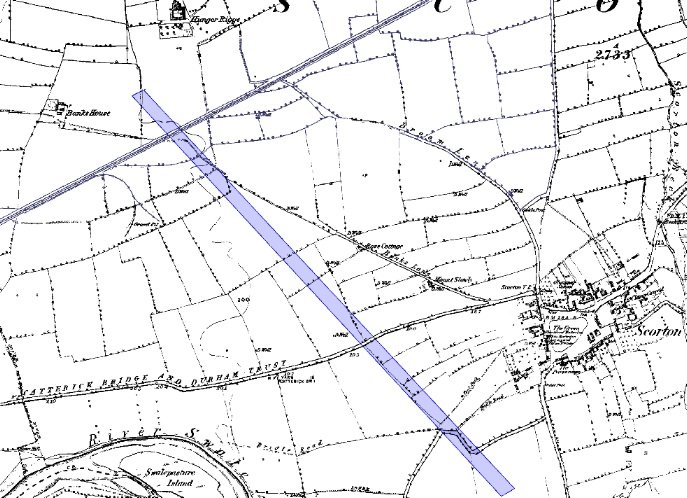
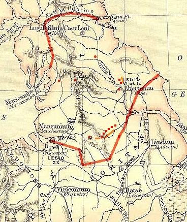
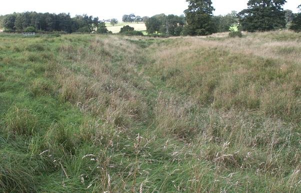
In 1720, the cartographer, Warburton created some of the first extensive maps of Yorkshire and Northumberland. Uniquely, he took pains to record the course of any Roman roads that were still visible, and recorded a Roman road which travelled from Grewelthorpe to Catterick (North Yorkshire). The road is recorded as passing close to Masham, through Kilgram (shown above), where it crossed the River Ure, continuing to Catterick via Newton le Willows and Hornby. This road was confirmed by the antiquarian John Fisher (1) some 100 years later however it has had little recognition in modern times. The course of this road is still visible to the south of Kilgram.

The construction of the ford will be described later, it’s size would tend to indicate this road was an important communication route during Roman times, it’s destination – Catterick being a known major centre will have been an important regional focal point, other sites close to the course of the route include a small camp at Roomer Common and a settlement of probable Iron Age origin close to Horsecourse Hill, Grewelthorpe. Little is known of these sites.

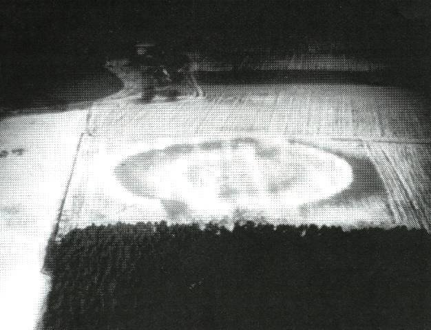
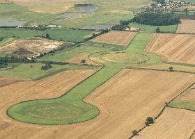
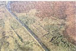
Kilgram Bridge from the air – Multimap.com

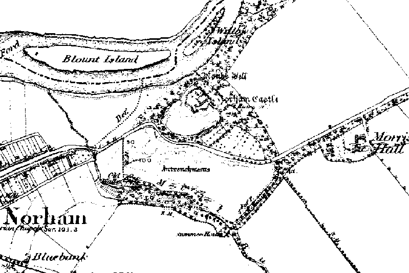
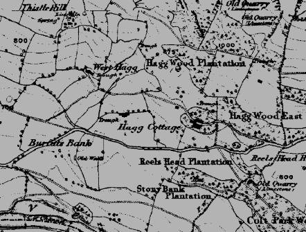
Kilgram Bridge in 1856 – OS map from old-maps.co.uk.

Clues that lie below – The Paved Ford

Dating of the ford

Without excavation evidence a firm conclusion as to the period of construction can only be arrived at using evidence as to the visible context of the ford – it’s location under Kilgram Bridge, and it’s manner of construction.

The fact that is sits under a Norman structure, known to exist from at least 1301, and probably built within a few years of the founding of the nearby Jervaulx Abbey – 1145 would tend to suggest it was built in a period prior to the Norman conquest. Other factors such as the building of the bridge directly over the structure indicate it had fallen out of use some time prior to the building of the bridge.

The use of lewis holes in it’s construction, as well as water hard mortar are clear indicators of a Roman origin, these features not re-occurring in Britain until long after the date of the bridge which rests upon it. The extensive use of steel straps to bond the structure together give further evidence of a Roman date. No such structures are known to have been built in either the Norman or Saxon periods.

Further evidence is suggested by the relationship with the Roman road reported by Warburton and confirmed by Fisher.

Taking this evidence together, it seems unlikely that this structure could be anything other than that of Roman origin. Fortunately, it’s watery context means that the wooden parts of its construction are still extant, and perhaps confirmation of it’s date can be obtained in future with the use of dendrochronology.

Construction of the ford

The structure of the ford sits directly under Kilgram Bridge. It is composed of large sandstone slabs, which are well squared, and vary in size from approx 70cm x 150cm to 45cm x 90cm. The slabs are closely laid across the river to form a ford approx 8 m in width and 24m in length, from one bank of the river to the other. Each slab is held together by white mortar.

Built out of sandstone, these very regular and in places massive stone blocks cross the river. The bridge uses it as a foundation.

Along the outside of the paved ford, a regular series of iron straps, held in place by whitened lead can be seen.

In places lengths of timber and the contents of postholes remain intact. Also to be noted is the mortar holding the stones in place.

Along the outside edges of the ford, along its length, a series of iron straps (opus revinctum) serve to further secure it’s structure. These are probably be held in place by now whitened lead, which is typical of Roman construction. Although the majority of the ford is hidden by a covering of marine plantlife, which has the effect of staining the stone red, in places a number of lewis holes – used to lift the stones into place can be seen.

The outer edges of the ford are protected from erosion by the river by a length of wooden plank. The whole structure is held in place by wooden piles approx 20cm in diameter, placed in approx 2m intervals.

One unusual feature of the ford, is that it broadens in width about two thirds of its length towards it’s southern end. It is assumed that this was to accommodate the direction of approach from the south.

Although it is generally considered that the Roman’s used fords extensively as a means of crossing rivers, paved fords are so far extremely rare finds in Britain, in his book “Roman Roads” Richard Bagshawe mentions only three to be known, two of which have been recently lost due to flood damage and development. The ford at Kilgram sits under an already scheduled monument and should be around for some time yet.

Lewis hole.

The only known paved fords in Britain are Roman, the width of this one compares favorably with the Roman ford at Kempston, Beds. And it’s construction appears to have been even more significant. The ford at Kempston apparently lacking the Opus Revinctum.

Known paved fords of Roman origin

There are three known Roman paved fords in Britain (others have been identified but have not been verified). These are at Iden Green (Kent), Poddington (Beds) and Kempston (Beds). The former two are small fords which cross streams. Only Kempston crosses a large river and as such should provide the closest comparison of the construction techniques used.

Discussion

Whilst research is still ongoing, the ford under Kilgram Bridge is highly likely to have been of Roman construction. The building methods and material used, the size of the ford and the known reference to a Roman road passing over this spot all point to this structure being of Roman origin. If this is so, then this ford is one of only four Roman paved fords known in Britain. Furthermore, it is potentially larger and more ornate than the largest Roman ford so far known – Kempston, Beds.

The width of the ford – approx 8m, compares favorably with the average width of major Roman roads in Britain of 22 pedes (6.5m) and importantly, is almost exactly the width of nearby Dere Street (26 pedes, 7.7m) and again marks this route as being of high importance during Roman times.

Of the three Roman mentioned by Bagshawe – Iden Green (Kent), Poddington (Beds) and Kempston (Beds). Only Kempston crosses a large river (The former two are small fords which cross streams.) and would have provided the closest comparison of the construction techniques used, however this was destroyed by recent floods.

The width of the ford – approx 8m, compares favourably with the average width of major Roman roads in Britain of 22 pedes (6.5m) and is almost exactly the width of nearby Dere Street (26 pedes, 7.7m). However, little is known with regard to the relationship between the width of Roman paved fords and the width of the roads they carried..

References

1. History of Mashamshire, John Fisher, 1860.
2. Roman Roads in Britain. Hugh Davies, 2002 Tempus.
3. Roman Roads, Richard W. Bagshawe, 2000, Shire.
4. Kevin Cale Archaeological Consultant – Kilgram Bridge (assessment and evaluation reports) 1998. English Heritage.

Housesteads, Northumberland

Images from Housesteads

Greta Bridge Roman Fort, County Durham

Southern rampart ditches.

Southern Rampart ditches.

Earthwork outside of the main fort are by the river Greta.

“The position at Greta Bridge presents many points of similarity with Bowes, but the rectangular area inclosed is 3 acres, and the Earthworks are more perfect, espacially on the south, where there is a fine double vallum and ditch with well-marked entrance 25ft in width. The fort lies between the River Greta and the Tutta Beck, just south of their junction, while the Rom,an Road skirts its northern edge, of which vestiges still remain in the gardens of the houses there. The eastern side descends in a double Scarp to the low, marshy bank of the Greta, while on the west, where the rampart has been lowered, the slope is more gentle towards the stream and the existing road occupies the place of the original ditch. The southern rampart, as at Bowes, shows a core of stone.” From Victoria Histories 1912

Eboracum, York, North Yorkshire

Altar from Micklegate, York.

“To the African, Italian and Gallic Mother Goddesses Marcus Minucius Audens, soldier of the 6th Legion Victrix and a pilot of the 6th Legion, willingly, gladly and deservedly fulfilled his vow”.

Audens will have been responsible for guiding vessels up the Ouse to York.

Fremington Hagg Cavalry Hoard, North Yorkshire

Fremington Hagg Roman Cavalry Hoard

The Fremington hoard was found sometime prior to 1833 and the objects were presented to the Yorkshire museum, further items however, were later presented to the British Museum in 1880 and there has be conjecture as to if both collections were from the same, or different hoards. Both however are attributed to Fremington Hagg and can therefore due to there similar constrution and design be treated as from the same deposition.

The hoard comprises of pendants, roundels and other objects related to “horse furniture” of Roman origin, which Graham Webster has suggested were of the period AD60-70, and were probably lost by a Roman force at a time prior to the conquest of Brigantia.

This is the strongest evidence of pre-conquest battle between the Romans and the Brigantes, in his paper “A hoard of Roman equipment from Fremington Hagg (Soldier and civilian in Roman Yorkshire, Leicester University Press 1971, p.107.) Graham Webster states: ” The Fremington Hagg Hoard is therefore most likely to be pre-Flavian and cannot be associated with the conquest of Brigantia in A.D. 71. There were, however, earlier incursions of Roman troops into this area. Tacitus records the events following the divorce of Venutius, when Cartimandua was kept on her throne by force of Roman arms, and fighting may have continued until the end of the governorship of Gallus (Annals, xii, 40). The circumstances of the find, although our total knowledge at present confined to the name of the find spot, would nevertheless seem to indicate a cache of loot taken after an engagement and hidden by a follower of Venutius, never to be recovered. It is even possible to imagine that the warrior may have been deceived by the sparkling, tinned sheen of the trappings into thinking of them as solid silver. It is difficult to conceive of this hoard being buried under Roman auspices.”

This find, together with the Earthwork dykes thrown up to separate Fremington from the Reeth valley, an area which was probably heavily engaged in lead mining at the time and was certainly an Iron Age centre would tend to indicate that this is the site of the first major engagement between Cartimandua and Venutius, the conjecture being that Venutius by force of otherwise had taken the area of Reeth, which was rich in the resources needed to fund his revolt against Cartimandua. Cartimandua, feeling the effect of this loss of territory, retaliated by attacking Venutius at Reeth. After laying seige to the Reeth area, Cartimandua found herself in difficulty, possibly pinned down in the Fremington area (Fremington Castle Manor, a folly, may have been built over a much earlier earthwork), and needed to send for Roman help. The Roman’s, realising the need for a rapid response, sent a cohort of cavalry to mount a rescue operation, which was a success, but not without the loss of Roman lives.

Rey Cross Marching Camp, Cumbria

Images from Rey Cross.

Rey Cross is one of the largest marching camps known in Britain, it is large enough to hold more than two legions (and therefore did) and has been dated to c. 71 A.D.

The Roman marching camp at Rey Cross is split by the A 66 trunk road. The camp is large having an area of about 20 acres. It is in the shape of a square, each side roughly 300 m long. It is one of the best preserved of its type in the country and the visitor can easily trace its boundaries by foot. It has a number of entrances, each protected by a small rampart called a tutuli which protected against a frontal assault against the gate. Its size shows that it was used as a temporary camp for a legion. This was very probably the resting place of the ninth legion, under the command of Cerialis, after the Battle of Stanwick in AD 72.

Research Notes

BOWES (NY 901121) C. J. Dunn reports that at the bottom of a steep cliff south of Rey Cross stony banks represent a linear settlement of small enclosures and hut circles. perhaps of Romano-British date. On Bowes Moor 500m to the northeast a small oval enclosure with an entrance on the south has been partly destroyed by a former quarry.Yorkshire Arch. Journal. Vol. 49 1977, p.17.

Contact Us
close slider