

This unexcavated and undated barrow matches many of other Late Neolithic / Early Bronze-Age round barrows (c. 2400–1500 BC) dotted along the flanks of the Yorkshire Dales.
This unexcavated and undated barrow matches many of other Late Neolithic / Early Bronze-Age round barrows (c. 2400–1500 BC) dotted along the flanks of the Yorkshire Dales.

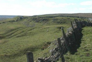
The Cleave dyke system is several Dykes which combine to create a boundary of between 9 and 18 kilometres running north south to the west of Thirsk.
Black Dike is the diminutive counterpart to the great Tor Dike, rising from its western arm and climbing to the watershed between Great and Little Whernside. Beginning at roughly SD 988 756—where Tor Dike cleaves the limestone scarp—the Black Dike pursues a steep, sinuous course uphill for nearly 0.6 km, finally spilling onto the ridge crest at about 675 m above sea level
Tor Dyke appears to have been attributed to Venutius which dates it of the period AD 52 – 70. The presence of a legionary size marching camp a few miles to the southwest at Malham certainly indicates an active role in the Roman advance of AD 70. However, given the lack of published research so far a clear picture has yet to emerge.

Bishopdale lies within the northern limb of the Askrigg Block, its underlying bedrock dominated by Carboniferous limestones with intermittent shales and sandstones of the Yoredale Series. The Great Scar Limestone, a thick, massive unit formed around 330 million years ago in a shallow tropical sea, underpins the dale’s steeper scarps and cliff lines, while the thinner-bedded limestones and intervening mudstones of the Yoredale Group create the characteristic terraced flanks on which many of Bishopdale’s field systems are laid out

The Kilburn White Horse is a large chalk hill figure cut into the limestone of Roulston Scar, the steep escarpment that defines the western edge of the Hambleton Hills in North Yorkshire. Carved in November 1857 and measuring roughly 97 by 67 metres, it was conceived not as an ancient relic but as a deliberate Victorian creation
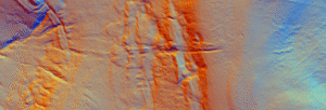
Castle dykes it is a small class one henge, 90m across, perched on the high ground up in the North Yorkshire dales. The bank survives up to 1.5 m high in places, and the ditch up to 3 m deep. Early 20th-century reports (1908) noted its intact form, and recent LiDAR-based surveys have confirmed its classic henge profile with minimal later disturbance.

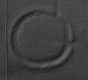
Archaeologists now recognise a true Neolithic henge lying immediately south-west of Moulton village, roughly midway between the Swale and Dere Street. The monument is almost 200 m across, with a low earthen bank encircling an inner ditch and a central platform about 110 m wide; the ditch lies inside the bank—the classic “Class II” henge arrangement.

This page is a master placeholder for all vitrified fort sites in the Vitrified Forts section of Brigantes Nation.
This had substantial ramparts made of stones with a timber frame, enclosing a large area and making good use of the natural defences of the hill-top.


