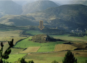
George

Author's posts

Arka Unskel Fort

Arka Unskel is 2½ miles ESE of Arisaig at NM693839 and has also been known as Ard Ghaunsgoik and Ard Ghamhgail. Described as on a promontory on the north side of Loch nan Uamh with a heavily vitrified wall.

East Yorkshire

Site GalleryGallery Empty

Lancashire

← BrigantiaLinked DocumentsThe Brigantes of LancashireAn interesting heading in Robert Morden’s map of Lancashire (1695) places “The Brigantes” in Lancashire. Worth investigating to try to understand exactly what Robert Morden was trying to portray here.Castercliff Hill FortThis denuded hillfort is oval and encloses almost two acres. The defences comprise triple circuits of bank and ditch, …

Continue reading

South Yorkshire

The county of South Yorkshire

North Derbyshire

In the county of Derbyshire

Northumberland

The county of Northumberland

Eboracum, York

Eboracum was the Roman capital of Northern England

Devil’s Arrows

This Bronze Age site comprises of three large standing stones, it is thought originally there were as many as five stones in this alignment. Being Bronze Age little is known about the origin of the Devil’s Arrows, the name reflecting a more recent myth. The monument is strongly linked with an alignment with several others covering a line of over 50 miles and heading north south through North Yorkshire.

Cleave Dyke Defensive System

The Cleave dyke system is several Dykes which combine to create a boundary of between 9 and 18 kilometres running north south to the west of Thirsk.

Catterick Roman Fort

The Fort at Catterick. It has an unusual shape due to multiple fort plans being overlayed on it. Originally it was a Roman fort, but a settlement soon sprang up outside the fort, which soon dominated the fort, and Catterick became one of the most important ‘Small towns’ in the north of Britain.

Contact Us
close slider

    What is 1 + 4 ?