Category: Archaeological Periods

Millbarrow long barrow (Winterbourne Monkton)

Tumulus on Millbarrow

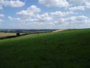
Millbarrow once stood on a low chalk spur 2 km north‑west of Avebury, just above the spring‑line where the Kennet valley opens onto the Marlborough Downs (NGR SU 0943 7221). From its east–west‑aligned crest the ground falls gently south to Windmill Hill and east  into the Kennet valley, giving the mound clear sight of the Avebury monument complex, and easy access to water and pasture.

Horslip (Windmill Hill) Long Barrow, Avebury

Horslip Barrow - AI Recreation

Sitting on the south‑east shoulder of Windmill Hill (grid ref. SU 086 070), 140 ft (43 m) above the Kennet valley, the Horslip long barrow commands the same chalk ridge that carries the famous Early‑Neolithic causewayed enclosure 400 m upslope.

Bubeneč Neolithic Farm, Prague

Bubenec excavations - Institute of Archeology of Academy of Sciences

Quite recently, initial excavation evidence from Bubenec, close to Prague was first announced to the public, pending full publication. As part of that media activity, the head archaeologist for the dig, Petra  Maříková  Vlčková explained that the excavation; below the future Canadian Embassy, in Prague’s Bubeneč district, cut through almost two metres of undisturbed deposits – a rarity in Central Europe.

Castro de Trona fort – Pontevedra, Spain

Petroglifo castro Troña

Castro de Trona is an oval enclosure with significant terracing to the west and a large ditch to the east. This castro (a hillfort settlement) has an accepted date of around 600 BCE. Like many others in Galicia, this castro reached its peak during the 1st and 2nd centuries CE. It measures approximately 200 metres east to west by 150 metres north to south.

Roman Road to the West uncovered under Manchester Street

Sections of a Roman road can be seen in this trench

A stretch of Roman road just 38-40 cm (15 in) below Liverpool Road in Castlefield. The trench shows the classic Roman construction sequence – a cambered rubble core surfaced with tightly packed cobbles – and runs on a north-east/south-west alignment that leaves Mamucium’s north gate and heads towards modern Salford.

Wellhill, Dunning Early Neolithic Farm – Perthshire

Dunning Perthshire - Satellite view of Wellhill prehistoric settlement

The village of Dunning in Perthshire, Scotland,  has been revealed through excavation as having traces of human activity dating back 10,000 years. This included evidence of what could be the earliest farming activity recorded in Scotland so far, and also remains of hunter-gathering activity dating back to the Mesolithic period.

Doncaster Roman Fort (Danum)

Dunum Roman Fort artistic impression

← South Yorkshire Roman Rig Defensive Works The Roman Rig is a defensive dyke built to defend against attack from the south. It runs from Sheffield, past Read more Templeborough Roman Fort – Rotherham Templeborough Roman Fort occupies a commanding position on the north bank of the River Don at Rotherham (OS grid SK Read …

Continue reading

Adwick-le-Street Roman Fort (Derventio)

Adwick-le-Street Roman Auxilliary Fort - Artistic Impression

Derventio was an auxiliary fort, it probably housed a mounted ala or an infantry cohort. It is located immediately west of modern Adwick le Street (OS SE 553 008), astride Ermine Street (the Roman Ridge).

Templeborough Roman Fort – Rotherham

Templeborough Roman Granary remains at Clifton Park Museum

Templeborough Roman Fort occupies a commanding position on the north bank of the River Don at Rotherham (OS grid SK 410 916), where the Magnesian Limestone ridge drops into the floodplain. Originally constructed in timber and earth in the mid–1st century AD, it was later rebuilt in stone and occupied—possibly intermittently—until the withdrawal of Roman authority in the early 5th century AD

Great Roe Wood (Roe Wood) Enclosure – Woodhouse

Great Roe Wood - Sheffield - OS Series 1

Great Roe Wood (often simply called “Roe Wood”) sits on the Magnesian Limestone ridge that carries the Roman Rig between Sheffield and Doncaster, just northeast of the village of Woodhouse (OS grid SK 450 920). This ridge forms a natural corridor overlooking the Don valley, with shallow soils over limestone giving way to deeper alluvial gravels in the valley bottom.

Contact Us
close slider