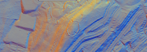
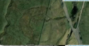
Camp Green (often called “Danes Camp”) crowns a limestone-capped knoll immediately north-east of St Michael’s Church in Hathersage (OS grid SK 234 819). Perched above the Hope Valley, it commands wide views down the River Derwent corridor and sits at the transition between the Millstone Grit plateaux to the north and the lower limestone and sandstone vale to the south
Category: Archaeological Periods
Dryburn Henge, Cumbria
Dryburn Henge lies on Alston Moor in Cumbria, within the North Pennines Area of Outstanding Natural Beauty. It occupies a strategic nodal point on the high moor, roughly at NY 760 430, where routes across the Pennine watershed converge. The surrounding terrain is underlain by Carboniferous Great Scar Limestone and interbedded Yoredale shales, with scattered fluvioglacial gravels in valley bottoms.
Black Dike – Coverdale
Black Dike is the diminutive counterpart to the great Tor Dike, rising from its western arm and climbing to the watershed between Great and Little Whernside. Beginning at roughly SD 988 756—where Tor Dike cleaves the limestone scarp—the Black Dike pursues a steep, sinuous course uphill for nearly 0.6 km, finally spilling onto the ridge crest at about 675 m above sea level


