Period: Unknown

Earthworks at the top of Holly Hill, Well

While details about these earthworks are not widely documented, the area is known for its rich archaeological significance. Holly Hill itself is a place of interest, with its Grade II listed status indicating its historical importance.

Staffordshire

Linked PagesTamworth CastleTamworth Castle, has known origins that trace back to Anglo-Saxon times when it served as a residence for the Mercian kings. The castle’s strategic importance was highlighted during the Viking invasions, leading to its abandonment.Site Details: Staffordshire RegionOther Notes:  Site GalleryGallery Empty

Earthworks at Stainton

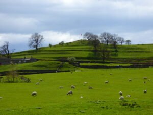
The earthworks surrounding Stainton in North Yorkshire are part of a rich archaeological tapestry that speaks to the region’s ancient past. These structures are believed to be remnants of extensive field systems, possibly dating back to the post-Roman period.

Grinton Lodge Earthworks

The earthworks that sit on the hillside between Grinton Lodge and the B6270 are part of a fascinating archaeological landscape in North Yorkshire. These features are distinct from the nearby Grinton-Fremington Dyke System, which dates back to the post-Roman period and is believed to have formed part of the boundary of an early British kingdom.

Roman Rig Defensive Works

The Roman Rig is a defensive dyke built to defend against attack from the south. It runs from Sheffield, past Templeborough and carries on almost to Doncaster. If this is a Brigantian dyke it would certainly add weight to Websters definition of the Roman border in the period.

Pickhill Mound

A large artificial mound here, apparently raised for defensive purposes, bears the name of Picts’ Hill, and an improbable belief prevails that the Picts defeated the Romans in battle at a spot, not far off, called Roman Castle. This mound is also known as Money Hill, but, though partially cut away for the construction of the railway, the traditionary hidden treasure was not found

Near Moor

At SE48090 98917 this Neolithic Pointer lay’s close to a Bronze Age Field System. I have explored this area several times and find that much more time is needed as it is a vast area called Near Moor and was due in pre-history connected to Scratch Wood Moor to the north west.

Maiden Castle Fort Reeth

For over five hundred years, the miners and smelters of Reeth produced mountains of precious lead. The lead ores from Reeth had high concentrations of Silver, Lead itself became and important ingredient in bronze. Maiden Castle, deep in the Swaledale lead mining territory a unique piece of Iron Age architecture. It is the only known fort with what seems to be a processional entrance.

Near Moor, North Yorkshire

Rock Art on Near Moor Site Notes For all my Grid Reference i give are from Ordnance Survey outdoor leisure 26 map ”North York Moors” western area. At SE48090 98917 this Neolithic Pointer lay’s close to a Bronze Age Field System. I have explored this area several times and find that much more time is …

Continue reading

Guide – LOS Analysis

A lone researcher stands atop a hill in the Yorkshire Dales

The purpose of using line of site analysis is to better understand the sites relationships with other locations, to identify possible trade and communications routes, and the location of other possible sites of interest, as well as providing an element of “evidence by association”.

Contact Us
close slider