
This page holds our Glossary of Terms for Vitrified Forts.
May 30
This page holds our Glossary of Terms for Vitrified Forts.

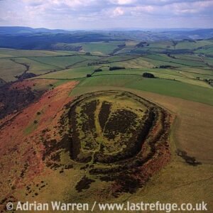
This is one of the best examples of a vitrified fort, it is near the village of Rhynie in northeastern Scotland. This massive fort from prehistory is on the summit of a mountain of the same name which, being 1,859 feet (560 metres) high, commands an impressive view of the Aberdeenshire countryside.
May 29
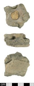
This article explores the most tangible evidence we possess for indigenous minting north of the Humber: the smashed ceramic “pellet-mould” trays recovered in quantity at Scotch Corner and, in lesser numbers, at Britain’s southern oppida.

How Hill, near Downholme in North Yorkshire, is the site of a large univallate hillfort.
May 25

The name Brigantia represents three separate concepts: a goddess, a people, and a tribal federation. By the Roman period, the name represented a tribal federation compromising all of what would become the Roman province of Britannia Secunda, except for the Parisi territory, east of the River Derwent.
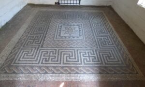
Aldborough, or Isurium Brigantia as it was known in Roman times was the capital of Brigantia, at least from some point during Cartimandua’s acceptance as client Queen, governed by Rome. As such, it is a key site in our search for Brigantia

Despite is unusually high position, this fort contains traces of a number of huts, and on investigation these have yielded plentiful pottery, as well as charcoal giving a surprisingly early radio carbon date

Summary and supplemental information in relation to the publication: Early‐Middle Bronze-Age Agricultural Terraces in North-East England: Morphology, Dating & Cultural Implications.

Flats Hill mound is approximately 30 meters in diameter and stands about 3.6 meters high. It has never been excavated, although a dry stone wall seems to have been started, and then stopped, partly over its top. It has been suggested as, and is listed as a probable barrow, with a presumably wide date, likely to be in the Bronze Age or Iron Age date range.
Mar 25
Caer Caradoc is often linked to Caradoc (or Caradog), a prominent figure in Welsh mythology and Arthurian legend. Caradoc is considered one of the knights of the Round Table in Arthurian lore, and he is sometimes referred to as Caradoc of the Battle or Caradoc the Brave. He was known for his bravery and his loyalty to King Arthur.
 NLS Map Explorer
 Google Earth
 Google Maps
 Lidar Finder
 TMA
TMA
 Megalithic Portal
 Yorkshire Arch. Air Mapping
 ADS
ADS
 Brigantian Adventure FB Group
Stone Bothering FB Group
Stone Faces FB Group
Brigantian Adventure FB Group
Stone Bothering FB Group
Stone Faces FB Group
 Heritage Gateway
 ARCHI® MAPS: UK
 Atlas of Hillforts
 Portable Antiquities
 British History Online
Brigantes Nation FB Group
British History Online
Brigantes Nation FB Group

