

An oppidum is the name given to a large population centre, with varying levels of fortification. So far, this concept of Iron-Age cities has not really been applied to the British Iron-Age, though many individual hillforts have been suggested.
Mar 25
An oppidum is the name given to a large population centre, with varying levels of fortification. So far, this concept of Iron-Age cities has not really been applied to the British Iron-Age, though many individual hillforts have been suggested.
Feb 11
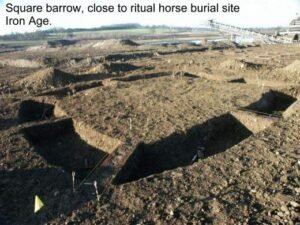
The Nosterfield Quarry excavation sits at the heart of one of Britain’s most enigmatic prehistoric landscapes—the Thornborough Henges Complex.
Feb 07

The ard, also known as a scratch plough, represents one of the earliest forms of agricultural technology used by the people of ancient Brigantia.
Jan 24

Breogán is a legendary figure in Galician mythology and is regarded as the founder of the Galician people. The myth of Breogán is part of the ancient Celtic tradition, and while the details of his story vary across sources, he is universally seen as a key figure in the mythological ancestry of the Galicians.
Jan 23
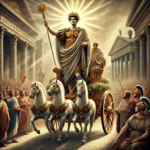
Julius Caesar made the first significant Roman attempt to conquer Britannia in 55 BCE during his campaign in Gaul. He landed on the shores of south-eastern Britain, but his invasions were brief and mostly for reconnaissance. Despite some skirmishes, there was no lasting conquest at this stage.
Jan 23

Understanding the archaeological periods across Western Europe is essential for exploring the evolution of human societies from prehistory to the beginnings of written history. These periods are generally defined by shifts in technology, social organization, and the environment, and they often vary slightly from region to region.

Ingleborough Hill, located in the Yorkshire Dales, is known for its prehistoric significance, particularly its hill fort. The hill fort atop Ingleborough is located at an elevation of about 723 meters (2,372 feet) above sea level, making it one of the highest known Iron Age settlements in the region.
“This offering to the goddess-nymph Brigantia, which he had vowed for the welfare and safety of our Lord the Invincible Emperor Marcus Aurelius Severus Antoninus Pius Felix Augustus and of his whole Divine House, Marcus Cocceius Nigrinus, procurator of our Emperor and most devoted to his divinity and majesty, gladly, willingly, and deservedly fulfilled.”
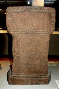
“To eternal Jupiter of Doliche and to Caelestis Brigantia and to Salus Gaius Julius Apolinaris, centurion of the Sixth Legion, at the command of the god (set this up).”
“To eternal Jupiter of Doliche and to Caelestis Brigantia and to Salus Gaius Julius Apolinaris, centurion of the Sixth Legion, at the command of the god (set this up).”
 NLS Map Explorer
 Google Earth
 Google Maps
 Lidar Finder
 TMA
TMA
 Megalithic Portal
 Yorkshire Arch. Air Mapping
 ADS
ADS
 Brigantian Adventure FB Group
Stone Bothering FB Group
Stone Faces FB Group
Brigantian Adventure FB Group
Stone Bothering FB Group
Stone Faces FB Group
 Heritage Gateway
 ARCHI® MAPS: UK
 Atlas of Hillforts
 Portable Antiquities
 British History Online
Brigantes Nation FB Group
British History Online
Brigantes Nation FB Group

