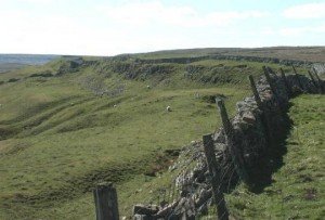
Finavon Hill has attracted a great deal of archaeological interest from antiquarians and archaeologists over the years especially since it displayed traces of vitrified rock.
Category: Iron Age
Eileen na Goar Fort
This island, locally termed Eilean na Goar, is the most eastern and is bounded on all sides by precipitous gneiss rocks; it is the abode and nesting place of numerous sea birds. The flat surface on the top is 120 feet from the sea level, and the remains of the vitrified fort are situated on this, oblong in form, with a continuous rampart of vitrified wall five feet thick, attached at the SW end to a large upright rock of gneiss
Dundon Hill Fort
← SomersetSite Details: Dundon Hill as it appears on the 1850 OS map. There is a plan and short description in volume 2 of the Victoria County History for Somerset (pages 490-1). Ian Burrow’s Hillfort and Hill-top Settlement in Somerset in the First to Eighth Centuries has a more recent (but less detailed) description at …
Clickhimin Broch
This site was occupied in several periods, originally late Bronze age between 700 – 500BC. Firstly a simple farmstead which expanded to a blockhouse (fort) and then by a huge circular broch. A population of around 60 lived in this little fortress. Later, 2nd century occupation is shown when a wheelhouse was added.
Castle Point Fort
← GrampianSite Details:Grid ref: NJ 837 661 Ordnance Survey Landranger series sheet no.s 29 and 30 10 miles W of Fraserburgh. Access to this promontory fort is by a motorable track N from the B9031 W of the steep-sided valley of the Tore of Troup. The site, which dominates the little Cullykhan Bay, is reached …
Castle Naze Hill Fort
This is a promontory fort of probable Iron Age date. It uses the natural cliffs of the hill that it stands to protect its northern and western sides. It is triangular in form, and in order to protect its south eastern face, a very impressive double rampart of possibly later Iron Age construction has been thrown up.