

The Iceni tribe, known in Latin as Icēnī, was a powerful and significant group during the Iron Age and early Roman era in what is now eastern Britain.
Jun 23
The Iceni tribe, known in Latin as Icēnī, was a powerful and significant group during the Iron Age and early Roman era in what is now eastern Britain.
Jun 19

Prehistoric Yorkshire is a landscape rich with history, revealed through various archaeological finds that offer a glimpse into the ancient past. The oldest evidence of human activity in this region dates back to around 125,000 years ago, but it is the later periods, particularly the Iron Age, that have yielded significant discoveries related to ploughing and farming.
Scott’s Dyke, also known as Scots Dyke or Scots Dike, is a significant linear earthwork stretching approximately fourteen kilometres from the River Swale to the River Tees, this ancient structure is believed to date back to the period between the first century BC and the first century AD.
Jun 14

Venutius was a notable figure in the 1st-century history of northern Britain, known primarily as the king of the Brigantes during the Roman conquest. The following text summarises what we can potentially understand about him, and tries to tie him to places and other possibilities that are not supported by the historical record. At the end of the section, what records to exist are explained.

The massive earthworks at Barwick and the continuation of the same profile alongside the River Cock to Aberford and beyond point to it being a place of importance as a large hillfort of some 15 acres. There were several hillforts in northern Britain when it was inhabited by a Celtic tribe called the Brigantes.

Redmire, a charming village nestled in the heart of North Yorkshire, England, boasts a rich tapestry of history that is as picturesque as its serene landscapes.

The field systems at Reeth are particularly noted for their historical coaxial layout, and are characterized by long, parallel boundaries that run across the landscape, a pattern indicative of significant central organization and planning.
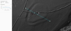
The subject of much speculation and, frankly, little fact this looks like a classic hill fort to us, check out the below elevation map of the area with the hillfort showing up beautifully. We have also included elevation profiles so you, dear readers, can appreciate the classic hill top location: note how from all directions the hillfort perches nicely on the top of the highest point: visible from all directions and can see in all directions. A classic see & be seen location, achieving the twin aims of defence and impressing visitors.
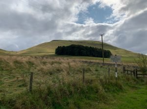
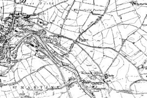
Wodens Law is actually the name of the great mountain that the Hill Fort is perched upon. Ok, so its not a mountain being a mere 500m high, but in this wild and desolate landscape it looks a lot more.The facts of the fort are impressive: there are multiple levels of ditch and bank defences surrounding the peak. There are considered to be three phases of occupation: firstly, a wall enclosed a substantial occupation area, this dated to the first century AD.

Sutton Common is an early Iron Age fort/enclosure site just north of Doncaster, A key feature of this “marsh fort” is that it seems to use the surrounding marsh land as part of its defence – a twist on the more common hill fort.
 NLS Map Explorer
 Google Earth
 Google Maps
 Lidar Finder
 TMA
TMA
 Megalithic Portal
 Yorkshire Arch. Air Mapping
 ADS
ADS
 Brigantian Adventure FB Group
Stone Bothering FB Group
Stone Faces FB Group
Brigantian Adventure FB Group
Stone Bothering FB Group
Stone Faces FB Group
 Heritage Gateway
 ARCHI® MAPS: UK
 Atlas of Hillforts
 Portable Antiquities
 British History Online
Brigantes Nation FB Group
British History Online
Brigantes Nation FB Group

