Bishopdale lies within the northern limb of the Askrigg Block, its underlying bedrock dominated by Carboniferous limestones with intermittent shales and sandstones of the Yoredale Series. The Great Scar Limestone, a thick, massive unit formed around 330 million years ago in a shallow tropical sea, underpins the dale’s steeper scarps and cliff lines, while the thinner-bedded limestones and intervening mudstones of the Yoredale Group create the characteristic terraced flanks on which many of Bishopdale’s field systems are laid out
Category: Brigantia
Castle Dykes Henge, Thoralby – North Yorkshire
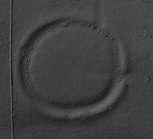
Castle dykes it is a small class one henge, 90m across, perched on the high ground up in the North Yorkshire dales. The bank survives up to 1.5 m high in places, and the ditch up to 3 m deep. Early 20th-century reports (1908) noted its intact form, and recent LiDAR-based surveys have confirmed its classic henge profile with minimal later disturbance.
Moulton Henge
Archaeologists now recognise a true Neolithic henge lying immediately south-west of Moulton village, roughly midway between the Swale and Dere Street. The monument is almost 200 m across, with a low earthen bank encircling an inner ditch and a central platform about 110 m wide; the ditch lies inside the bank—the classic “Class II” henge arrangement.
May 25
Brigantes Tribe
The name Brigantia represents three separate concepts: a goddess, a people, and a tribal federation. By the Roman period, the name represented a tribal federation compromising all of what would become the Roman province of Britannia Secunda, except for the Parisi territory, east of the River Derwent.
May 22
Coverdale: Nathwaite Bridge river crossing points
Nathwaite Bridge, over the river Cover in Coverdale, is just about the only way any heavy traffic can easily cross between the key villages of Carlton and West Scrafton. The importance of the location is perhaps underlined as the last place down the river Cover where it remains reasonably ford-able, and therefore crossable in past times when no closer bridge existed.


