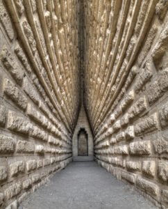
A barrow is a mound of earth and/or stones raised over a grave or group of graves. Used from the Neolithic through to the Iron Age (roughly 4000 BCE to 500 CE), barrows were often constructed to honour elite individuals, such as tribal leaders, warriors, or chieftains. They are frequently found singly or in cemeteries known as barrow fields.
Category: Landscape Archaeology
Moulton Henge
Archaeologists now recognise a true Neolithic henge lying immediately south-west of Moulton village, roughly midway between the Swale and Dere Street. The monument is almost 200 m across, with a low earthen bank encircling an inner ditch and a central platform about 110 m wide; the ditch lies inside the bank—the classic “Class II” henge arrangement.
May 22
Coverdale: Nathwaite Bridge river crossing points
Nathwaite Bridge, over the river Cover in Coverdale, is just about the only way any heavy traffic can easily cross between the key villages of Carlton and West Scrafton. The importance of the location is perhaps underlined as the last place down the river Cover where it remains reasonably ford-able, and therefore crossable in past times when no closer bridge existed.
May 18
Guide – Introduction to the European Ice Age
Antonine Wall Map Gask Ridge Map Roman Military Sites in Scotland English names, Roman names where known, four figure map reference, site type, size, and history, including garrisons and associated military Read more Mystery of Vitrified Forts It was during a trip to.Scotland, in the Summer of 1997, that I first heard of vitrified hillforts. …
Jan 23
Guide – Landscape Archaeology: Post-Ice Age Landscape of Thornborough
The landscape of Thornborough before the arrival of humans was shaped by the end of the last Ice Age, approximately 10,000 years ago. As the glaciers receded, the land began to warm, leading to the rebirth of plant and animal life. The area would have been covered by a mosaic of vegetation that slowly replaced the tundra-like conditions left behind by the retreating ice sheets.

