
Site GalleryGallery Empty
Map Icon: Ridge and Furrow
Lancashire
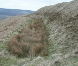
← BrigantiaLinked DocumentsThe Brigantes of LancashireAn interesting heading in Robert Morden’s map of Lancashire (1695) places “The Brigantes” in Lancashire. Worth investigating to try to understand exactly what Robert Morden was trying to portray here.Castercliff Hill FortThis denuded hillfort is oval and encloses almost two acres. The defences comprise triple circuits of bank and ditch, …
South Yorkshire
The county of South Yorkshire
North Derbyshire
The transformation of North Derbyshire from 50AD to the present is a fascinating journey through time, reflecting broader historical shifts in Britain. Initially, during the Roman conquest of Britain, Derbyshire fell under the influence of the Roman Empire, becoming part of the province of Flavia Cæsariensis.
Northumberland

The county of Northumberland, with its rich tapestry of history, has undergone significant transformation since 50 AD. Initially, under Roman occupation, Northumberland was a frontier zone, where Hadrian’s Wall marked the edge of the Roman Empire. Post-Roman Britain saw the region become a part of the Anglo-Saxon kingdom of Northumbria, a name meaning ‘north of the Humber’, reflecting its vast expanse.
Cumbria

The county of Cumbria
County Durham

The county of Durham
North Yorkshire

The County of North Yorkshire.
West Yorkshire
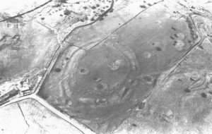
← BrigantiaLinked DocumentsCastle Hill, AlmondburyUnderneath these medieval earthworks is a series of earlier defenses which dates back to the early Iron Age. This was the building which burned down and it is regarded as one of Yorkshire’s most important early Iron Age hill forts, it is one of Yorkshires true multi-valet hill forts and gives …
- 1
- 2
 PAS North Yorkshire
- NLM-235F92 COIN ROMAN 4 February 2025Copper alloy coin fragment. Probably a radiate indeterminate, later Roman issue of 260-296; about half the flan is lost to a recent break.Obverse description: [bust]Reverse description: figure standing left with right hand outstretched.Reverse inscription: probably VIR(TVS AVG)Diameter: 17.1mm, Weight: 0.86gms
- NLM-233742 RIVET POST MEDIEVAL 4 February 2025Copper alloy rivet. Cylindrical shank of diameter 5.1mm with a round flat head and with its other end passing through a larger circular rove, being burred on the other side of it. The rivet passed through leather of thickness 11mm to judge from the space between its head and the rove. Suggested date: Post-Medieval, 1800-1900Length: […]
- NLM-22EAF7 COIN ROMAN 4 February 2025Copper alloy coin. Nummus of the House of Constantine (306-361), probably Constantine II (317-340), Gloria Exercitus issue of 330-335, Reece period 17Obverse description: bust laureate cuirassed right, seen from front.Obverse inscription: possibly CONSTANTINVS IVN [NOB C]Reverse description: two soldiers with two standards between them.Reverse inscription: [GLORIA EXERCITVS]Diameter: 14.8mm, Weight: 1.71gms, die axis: 6
- NLM-2287D1 COIN EARLY MEDIEVAL 4 February 2025Silver coin. Northumbrian non-pictoral sceat of Ethelred I, first reign, 774-778, by moneyer Ceolbald [Abramson 2006 page 130].Obverse description: central cross potent; initial cross potentObverse inscription: +AEDILREDReverse description: central ring of pellets round larger plain boss; initial cross potent.Reverse inscription: +CEOBALDDiameter: 13.7mm, Weight: 0.84gms, die axis: 3
- NLM-226339 RIVET POST MEDIEVAL 4 February 2025Copper alloy rivet. A cylindrical flat-headed rivet of diameter 5.3mm whose end passes through a wider circular rove, being hammered and burred to fix it in place. This object was presumably attached to leather of thickness 9mm, an inference from the space between rivet head and rove. Suggested date: Post-Medieval, 1800-1900Length: 14.8mm, Diameter (rove): 14.5mm, […]
PAS West Yorkshire
- YORYM-8E1BC7 BUCKLE MEDIEVAL 28 January 2025A complete copper-alloy buckle of medieval date, c.AD 1250 -1500. Meols Type 2.The buckle is a single looped D-shape with a narrowed and recessed strap bar. A grooved pin rest is present on the upper surface of the outside edge of the loop. A circular sectioned pin is fitted around the bar by an open loop. A rectangular […]
- YORYM-8E4F89 BUCKLE MEDIEVAL 28 January 2025A complete copper-alloy buckle of medieval date, c.AD 1250-1500. Meols Type 1.The buckle is a single looped D-shape with a narrowed strap bar. The upper surface of the frame has been decorated with four groups of four parallel incised grooves. A rectangular sectioned pin is fitted around the bar by an open loop. A rectangular plate is looped […]
PAS South Yorkshire
- YORYM-8FC319 HARNESS PENDANT MEDIEVAL 28 January 2025An incomplete copper-alloy gilded zoomorphic harness pendant of medieval date, AD 1200 - 1400.The pendant comprises a D-shaped plate in the form of a forward-facing animal's head, probably a stag, with integral attachment loop. The upper surface is moulded with features including pellet eyes, an elongated raised muzzle, and rounded snout. The reverse is flat and undecorated. The attachment […]
- NMGW-C31C53 CHARIOT FITTING IRON AGE 24 January 2025Addendum to an Iron Age sacred lake assemblage: a Late Iron Age bridle-bit and terret (50 BC - AD 75)1. Two-link bridle-bit, Polden Hill Subtype, bronze, complete Dimensions: maximum length 238.0mm; external rein-ring diameters (1)73.8-74.0mm & (2) 73.5-74.7mm; internal rein-ring diameters (1) 55.6mm & (2) 56.3mm; thickness rein rings – side to side (1) 8.3-9.0mm & […]


