

This mound is 22ft. in diam. and about 3ft high. It has been built upon a natural knoll which makes the barrow look larger than it is. Excavation showed that the mound has an earthy core with a rubble capping.
This mound is 22ft. in diam. and about 3ft high. It has been built upon a natural knoll which makes the barrow look larger than it is. Excavation showed that the mound has an earthy core with a rubble capping.
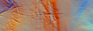
Black Dike is the diminutive counterpart to the great Tor Dike, rising from its western arm and climbing to the watershed between Great and Little Whernside. Beginning at roughly SD 988 756—where Tor Dike cleaves the limestone scarp—the Black Dike pursues a steep, sinuous course uphill for nearly 0.6 km, finally spilling onto the ridge crest at about 675 m above sea level
Jun 27

A gazetteer of probable prehistoric mounds, cairns and boundary earthworks in Coverdale. It is not complete and is still being researched.
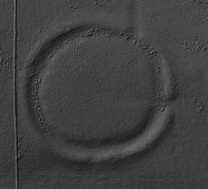
Castle dykes it is a small class one henge, 90m across, perched on the high ground up in the North Yorkshire dales. The bank survives up to 1.5 m high in places, and the ditch up to 3 m deep. Early 20th-century reports (1908) noted its intact form, and recent LiDAR-based surveys have confirmed its classic henge profile with minimal later disturbance.
Jun 11

These are raised platforms created first and foremost for cult, procession, assembly or conversion—not for fortification or routine boundary-making. They tend to be much more significant and monumental than other mounds and raised platforms. Some are the largest structures known of their type. In Britain, possibly the best known example is Silbury Hill in Wiltshire.
Jun 10

Guide: Common Features of Iron Age Hillforts This article attempts to serve as a guide for many of the features of the hillforts found in Britain, in Read more Guide: Iron-Age minting: Ceramic Pellet-mould trays This article explores the most tangible evidence we possess for indigenous minting north of the Humber: the smashed ceramic “pellet-mould” …
Jun 07
Synthetic-aperture radar (SAR) already relies on Doppler shifts: echoes from scatterers in a side-looking radar beam have slightly different frequencies as the platform flies past, and focusing those micro-shifts yields a two-dimensional image.
Jun 05

Archaeologists use the word “henge” for later-Neolithic and earliest Bronze-Age earthen rings whose ditch lies inside the bank, creating a deliberately bounded interior. The term itself was coined in 1932 by Kendrick; it was refined in the 1950s by Richard Atkinson, whose system still frames most discussion.

Archaeologists now recognise a true Neolithic henge lying immediately south-west of Moulton village, roughly midway between the Swale and Dere Street. The monument is almost 200 m across, with a low earthen bank encircling an inner ditch and a central platform about 110 m wide; the ditch lies inside the bank—the classic “Class II” henge arrangement.
Jun 01

Imagine being able to see the landscape around you in a completely new way—an invisible layer revealing the hidden structures of the past, right beneath the surface.
 NLS Map Explorer
 Google Earth
 Google Maps
 Lidar Finder
 TMA
TMA
 Megalithic Portal
 Yorkshire Arch. Air Mapping
 ADS
ADS
 Brigantian Adventure FB Group
Stone Bothering FB Group
Stone Faces FB Group
Brigantian Adventure FB Group
Stone Bothering FB Group
Stone Faces FB Group
 Heritage Gateway
 ARCHI® MAPS: UK
 Atlas of Hillforts
 Portable Antiquities
 British History Online
Brigantes Nation FB Group
British History Online
Brigantes Nation FB Group

