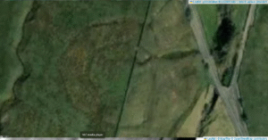
Scholes (or Scoles) Coppice Camp (sometimes called “Caesar’s Camp”) lies just north-west of Kimberworth in Rotherham, atop the same Magnesian Limestone ridge that carries the Roman Rig. Its grid reference is roughly SE 436 937, placing it only 200–300 m to the north of the Rig’s northern branch
Category: Brigantia England
Dryburn Henge, Cumbria
Dryburn Henge lies on Alston Moor in Cumbria, within the North Pennines Area of Outstanding Natural Beauty. It occupies a strategic nodal point on the high moor, roughly at NY 760 430, where routes across the Pennine watershed converge. The surrounding terrain is underlain by Carboniferous Great Scar Limestone and interbedded Yoredale shales, with scattered fluvioglacial gravels in valley bottoms.
Black Dike – Coverdale
Black Dike is the diminutive counterpart to the great Tor Dike, rising from its western arm and climbing to the watershed between Great and Little Whernside. Beginning at roughly SD 988 756—where Tor Dike cleaves the limestone scarp—the Black Dike pursues a steep, sinuous course uphill for nearly 0.6 km, finally spilling onto the ridge crest at about 675 m above sea level
Castle Dykes Henge, Thoralby – North Yorkshire
Castle dykes it is a small class one henge, 90m across, perched on the high ground up in the North Yorkshire dales. The bank survives up to 1.5 m high in places, and the ditch up to 3 m deep. Early 20th-century reports (1908) noted its intact form, and recent LiDAR-based surveys have confirmed its classic henge profile with minimal later disturbance.


