Boltby is a very important ancient site IMO. A gold “hair braid”, was found there, linking it to the Amesbury Archer, buried with two similar hair braids. This also provides a link to the founding of Stonehenge, which helps set a potential scene for a possible “zeitgeist”, of the day.
Category: Brigantia
Nov 23
The Story of Boltby Scar
- Filed under Brigantes, Brigantia, Brigantia England, Britain, Bronze Age, Celtic Tribes, Defensive Dike, Defensive Walls, Dike, Europe, Fort, Hair Braid - Ring, Hill Fort, Iron Age, Landscape Archaeology, Linear Earthworks, Mining Landscape, Promontory fort, Stories of Brigantia
Swaledale
- Filed under Brigantia, Brigantia England, Britain, Cairn, Europe, Flint Scatters, Geology, Geomorphology, Hill Fort, Iron-Age, Megalithic, New Sites, Promontory fort, Ring Cairn, Rock Art, Univallet Hillfort
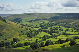
Swaledale occupies the long, sinuous valley carved by the River Swale on its 45-kilometre descent from Nine Standards Rigg (662 m) on the Pennine watershed to Richmond in lower Teesdale. The dale narrows between rough gritstone scarps near Keld, broadens to a patchwork of hay-meadows around Muker and Gunnerside, then opens into a tree-fringed flood-plain west of Reeth before the river cuts through the Carboniferous escarpment to meet the Vale of Mowbray.
- Arkengarthdale, Bainbridge, Barns, Benedictine, Blakethwaite Smelt Mine, Brigante, Brigantes, Brigantia, Bunton, Buttertubs, cairn, Cateractonium, Catterick, Cistercian, Corpse-way, Crackpot, Craclpot, Cup-mark, Deer Park Wood, Downholme, Dyke, Dykes, East Gill Force, Ellerton Abbey, Enclosure Acts, field-barns, Fort, Fountains Abbey, Franciscan, Fremington Edge, Fremmington, Friary, Gangs Flats, Gill, Great Pinseat, Great Scar, Great Scar Limestone, Great Shunner, Greyfriars, Grinton, Grinton Moor, Gunnerside, Gunnerside Gill, Harkerside Moor, Hay-meadow, hay-meadows, Healaugh, Herkersdie Moor, Hill Fort, Hind Rake, How Hill, Humber-Flanders export route, Hunter Gatherer, Hush, Hushes, Iron Age, Ivelet Bridge, Keld, Keldside, Kisdon Force, Kisdon Hill, Lead Mining, Lead-veins, Lower Teasdale, Lower Teesdale, Maiden Castle, market, Marrick Priory, Marske, Marske Deer Park, Marske Hall, Meadow, Mine, Mining, monk, Monks, Muker, Norse, North Yorkshire, nun, Nuns, Old Gang, Packhorse Bridge, Parliamentary Walls, Penine Watershed, Pennine watershed, Reeth, Richmond, Rievaulx Abbey, Ring Cairn, River Swale, Rock, rock-art, Roman, Sheep, Shunner Fell, Skeb Skeugh, Smelt, smelting, St Martin's Priory, Stainmore, Standards Rigg, stone, Swale, Swaledale, Tan Hill, Tan Hill Pub, terraces, Thwaite, Trajanic Lead Pig, vale of Mowbray, Walburn, White Rigg, Wool, Yorkshire Dales
- Leave comment
County Durham
- Filed under Brigantia, Brigantia England, Britain, Europe
County Durham’s landscape is often described as a “three-belt county.” To the west rise the high, windswept Pennines; in the middle lies a sheltered coal-bearing vale that funnels every main road and railway; and to the east stands the pale Magnesian-Limestone escarpment ending in low cliffs above the North Sea.
Cana Barn Henge
- Filed under Brigantia, Brigantia England, Britain, Class IIa, Europe, Henge, Liminal Spaces, Neolithic, New Sites
The stats for this Neolithic monument are astounding: 200m across, once a great circle of earthen banks and deep ditches. Today, almost lost: 5,000 years of plough and neglect have flattened the banks and filled the ditches, and Cana Henge is now nothing but a smoothly undulating grassy field on the moor overlooking Ripon.
Castro de Trona fort – Pontevedra, Spain
- Filed under Brigantia, Brigantia Espania, Castro Hillfort, Fort, Late Iron Age, New Sites, Roman, Terraces
Castro de Trona is an oval enclosure with significant terracing to the west and a large ditch to the east. This castro (a hillfort settlement) has an accepted date of around 600 BCE. Like many others in Galicia, this castro reached its peak during the 1st and 2nd centuries CE. It measures approximately 200 metres east to west by 150 metres north to south.
Roman Road to the West uncovered under Manchester Street
- Filed under Brigantia, Brigantia England, Britain, Europe, News, Pottery, Roman, Roman army, Roman Culture, Roman pottery, Roman Roads, Samian ware, Samian ware
A stretch of Roman road just 38-40 cm (15 in) below Liverpool Road in Castlefield. The trench shows the classic Roman construction sequence – a cambered rubble core surfaced with tightly packed cobbles – and runs on a north-east/south-west alignment that leaves Mamucium’s north gate and heads towards modern Salford.
- Agger, Bremetennacum, butchered animal bone, Chester, coarse utilitarian jars, Coccium, Condate, decorated glass, Deva, Deva Victrix, Eboracum, England, Lancashire, Liverpool Road, Liverpool Street, Mamucium, Manchester, Metalled Road, Northwich, Ribchester, Roman Britain, Roman Road, Samian ware, Street, Wigan, York
- Leave comment
Doncaster Roman Fort (Danum)
- Filed under Brigantia, Brigantia England, Britain, Defensive Structures, Europe, Fort, New Sites, Roman, Roman army
← South Yorkshire Roman Rig Defensive Works The Roman Rig is a defensive dyke built to defend against attack from the south. It runs from Sheffield, past Read more Templeborough Roman Fort – Rotherham Templeborough Roman Fort occupies a commanding position on the north bank of the River Don at Rotherham (OS grid SK Read …
Adwick-le-Street Roman Fort (Derventio)
- Filed under Brigantia, Brigantia England, Britain, Europe, Fort, New Sites, Roman, Roman army
Derventio was an auxiliary fort, it probably housed a mounted ala or an infantry cohort. It is located immediately west of modern Adwick le Street (OS SE 553 008), astride Ermine Street (the Roman Ridge).
Templeborough Roman Fort – Rotherham
- Filed under Brigantia, Brigantia England, Britain, Defensive Structures, Europe, Fort, Late Iron Age, Roman, Roman army
Templeborough Roman Fort occupies a commanding position on the north bank of the River Don at Rotherham (OS grid SK 410 916), where the Magnesian Limestone ridge drops into the floodplain. Originally constructed in timber and earth in the mid–1st century AD, it was later rebuilt in stone and occupied—possibly intermittently—until the withdrawal of Roman authority in the early 5th century AD
Great Roe Wood (Roe Wood) Enclosure – Woodhouse
- Filed under Brigantia, Brigantia England, Dark Ages, Dark Ages Brigantia, Iron Age, Late Iron Age
Great Roe Wood (often simply called “Roe Wood”) sits on the Magnesian Limestone ridge that carries the Roman Rig between Sheffield and Doncaster, just northeast of the village of Woodhouse (OS grid SK 450 920). This ridge forms a natural corridor overlooking the Don valley, with shallow soils over limestone giving way to deeper alluvial gravels in the valley bottom.
Articles
- Bronze Age
- Iron Age
- Roman
- Dark Ages
- Early Christian
- Viking
- Saxon
- Medieval
- Vitrified Fort
- Archaeology Guide
- Guide – Introduction to Critical Thinking in Archaeological Research
- Guide – Challenging Assumptions with Free Thinking
- Guide – Congruence in Archaeological Interpretation: Holistic Analysis
- Guide – Critical Thinking: Lack of Evidence Does Not Mean Evidence of Lack
- Guide – Critical Thinking: The Simple Assumption
- Guide – Applying critical thinking to historic and archaeological research
- Guide – Empathic Archaeology Introduction
- Guide – Landscape Archaeology Introduction
- Guide – What is Landscape Archaeology?
- Guide – Introduction to Glacial Archaeology
- Guide – The Flora and Fauna of Prehistoric Britain
- Guide – Landscape Archaeology: Post-Ice Age Landscape of Thornborough
- Guide – Archaeological Periods in Western Europe
- Guide – Visible Remains
- Guide – Hidden Remains
- Guide – Getting Started
- Guide – Landscape Features
- Guide – Agricultural practices through time
- Guide – Introduction to Glacial Archaeology
- Guide: In Depth – Church Doors and Windows
- Guide – Mining
- Guide – Archaeological Terms
- Guide – Glossary
- Latin Translation – Choosing the meaning of AUG
- Reports
- An introduction to Brigantian Druidry
- Brigantia during the Dark Ages
- Celtic Heads
- Finding Bardon – An Arthurian Quest
- Early Christian syncretism and how the old ones hid amongst the new religion
- Rome: The Emperors Claim to Divinity
- Syncretism through the ages
- The Border Reivers
- The Gallus Frontier – Brigantia against the Romans
- The growth of Christianity 50AD – 1100AD
- The Kingdom of Venutius
- The use of the word Lady in relation to water related structures
- The walled gardens of Brigantia
- Yorkshire’s “Sacred Vale” – The Dawn of Brigantia
- Brigantia Espania
- Iberian Peninsular
- Galicia
- Biefing – The Myth of Breogán and the Tower of Heracles
- Briefing – Galicia’s Political History and Separatist Sentiment
- Briefing – Geography and Geology of Galicia
- Briefing – Design of Galician Hillforts
- Briefing – Roman Interaction with Galicia and the Iberian Peninsula
- Church of Santa María de Cambre, Cambre near A Coruña
Categories
- Agriculture (6)
- Field Systems (1)
- ploughing (2)
- Angle (2)
- Archaeological Periods (312)
- Anglo-saxon (6)
- Bronze Age (52)
- Late Bronze Age (1)
- Dark Ages (24)
- Dark Ages Brigantia (9)
- Early Christian (37)
- Early Medieval (8)
- Georgian (9)
- Gothic (3)
- Ice Age (1)
- Iron Age (133)
- Late Iron Age (5)
- Jacobite (7)
- Medieval (61)
- Medieval Brigantia (9)
- Mesolithic (11)
- Neolithic (45)
- Early Neolithic (5)
- Norman (40)
- Palaeolithic (6)
- Roman (94)
- Saxon (9)
- Stuart (6)
- Suspect (1)
- Tudor (10)
- Undated (7)
- Viking (4)
- Archaeology (93)
- Archaeobotanical (1)
- Empathic Archaeology (11)
- Free Thinking (7)
- Battle (1)
- Brigantia (147)
- Brigantia England (134)
- Brigantia Espania (11)
- Civil Structure (6)
- Defensive Structures (45)
- Castle (5)
- Defensive Dike (2)
- Defensive Walls (1)
- Fort (20)
- Fortified Barn (1)
- Marching Camp (5)
- Motte and Bailey (6)
- Ring Work (1)
- Class A (1)
- Dialects (1)
- Earthworks (51)
- Dike (8)
- Field Systems (26)
- Enclosure (12)
- Enclosure Acts (1)
- Europe (51)
- Festivals (2)
- Finds (42)
- Altar (10)
- Amphora (1)
- Animal Remains (4)
- Auroch (1)
- Hoof marks (1)
- Antler Pick (2)
- Arrowhead (1)
- Leaf-shaped (1)
- Axe (1)
- Bone Comb (1)
- Celtic Head (8)
- Celtic Head (2)
- Clock (1)
- Curse Tablet (1)
- Flint Scatters (4)
- Gaming Pieces (1)
- Hair Braid – Ring (4)
- Human Remains (2)
- Adult (1)
- Couched Burial (1)
- Juvinile (1)
- Mace Head (1)
- S-curved (1)
- Mosaic (1)
- Polished Stone Adze (1)
- Pottery (8)
- Funerary Urns (2)
- Grooved ware (1)
- Peterborough ware (1)
- Mortlake ware (1)
- Planig‑Friedberg ware (1)
- Samian ware (2)
- Vasi a Bocca Quadrata ware (1)
- Quern Stones (1)
- Statue (1)
- Geography (16)
- Maps (7)
- Geology (13)
- Anthracite – Coal (2)
- Geomorphology (2)
- Gods (9)
- Guide (72)
- Critical Thinking (8)
- Socratic Thought (1)
- Glossary (1)
- Hidden Remains (8)
- Geophysics (5)
- LiDAR (1)
- Radiocarbon Dating (1)
- Remote Sensing and Analysis (1)
- Regional Surveys (13)
- Research Tools (4)
- Visible Remains (12)
- Air Mapping (2)
- Air Photography (2)
- Fieldwalking (2)
- Lithics (1)
- Photography (6)
- Critical Thinking (8)
- Henge (18)
- Hill Fort (61)
- Castro Hillfort (3)
- Contour/Plateau Fort (1)
- Multivallete Hillfort (1)
- Oppidum (1)
- Oppidum (1)
- Promontory fort (4)
- Slavic Gord (1)
- Univallet Hillfort (4)
- Vitrified Fort (27)
- Historic Buildings (20)
- Amphitheatre (1)
- Barn (2)
- Beacon (1)
- Broch (1)
- Coaching Inn/Hostelry (1)
- Folly (4)
- Hall (2)
- Hospital (1)
- House (1)
- Tower (7)
- Walled Garden (1)
- Industrial Heritage (9)
- Chimney (1)
- Mining (9)
- Spoil Heap (1)
- Smelting (2)
- Iron-Age (1)
- Landscape Archaeology (38)
- Glacial Archaeology (2)
- Landscape Legislation (1)
- Mining Landscape (1)
- Ritual Landscape (6)
- Landscape feature (49)
- Barrow (18)
- Bell Barrow (2)
- Bowl Barrow (1)
- Cairn (2)
- Disc Barrow (1)
- Long Barrow (5)
- Ring Barrow (1)
- Ring Cairn (1)
- Round Barrow (1)
- Square Barrow (1)
- Steppe Kurgan (1)
- Boundary Marker (2)
- Burial Mound (9)
- Ceremonial Mount (1)
- Cursus (2)
- Hill Figure (5)
- Linear Earthworks (2)
- Mound (6)
- Passage Tomb (1)
- Ring Cairn (2)
- Snake Mound (1)
- Terraces (3)
- Barrow (18)
- Leaders (33)
- Agricola (2)
- Arthur (1)
- Augustus Caesar (2)
- Breogans (3)
- Caratacus (1)
- Cnut (1)
- Julius Caesar (1)
- Petilius Cerialis (1)
- Liminal Spaces (1)
- Market (1)
- Megalithic (10)
- Rock Art (3)
- Stone alignment (1)
- Stone Circle (7)
- stone circles (1)
- Stone Row (2)
- Myth and Legend (5)
- New Sites (23)
- Publications (21)
- Biographies (2)
- Henge Capital of Britain (10)
- News (4)
- Stories of Brigantia (4)
- Walking Guides (1)
- Rabbit Warren (1)
- Religious Structures (31)
- Abbey (3)
- Church (24)
- Crosses (1)
- Memorial Planting (1)
- Priory (2)
- Religious Orders (3)
- Ritual walkway/pilrimage path (1)
- Reports (148)
- Roman Culture (11)
- Roman army (8)
- Roman baths (1)
- Roman City (1)
- Roman Gods (1)
- Mercury (1)
- Roman navy (1)
- Roman pottery (3)
- Samian ware (2)
- Roman Road (1)
- Roman Roads (2)
- Roman Villa (2)
- The Celtic World (35)
- Celtic Gods (1)
- Lugh (1)
- Celtic Industry (1)
- Celtic Life (9)
- Celtic Trade (1)
- Celtic Tribes (27)
- Celtic Gods (1)
- Trade (4)
- Minting (3)
- Coins (1)
- Spoil Heaps (2)
- Minting (3)
- Translation (7)
- Inscription (4)
- Latin (5)
- Uncategorized (24)
- Water Works (13)
Research Links
 Heritage Gateway
Announcing: The Brigantian News!
- Roman Road to the West uncovered under Manchester Street 16 July 2025
- What might Stonehenge Mean? Dartmoor and Carnac add to the Picture 3 July 2025
- Megalithic Stone Monuments in France May Be Europe’s Oldest 1 July 2025
- Drumanagh Promontory Fort – First Ever Intact Roman Pot Found in Ireland 5 June 2025
Portable Antiquities News
A Post Medieval copper-alloy jetton of uncertain issue dating to the period AD 1550 - 1750. Rose/Orb type. Mint of Nuremburg.Obverse: Alternating crowns and lis with central rose.Reverse: Imperial Orb within tressure of three arches. [...]
A Post Medieval copper-alloy rose farthing of Charles I (AD 1625-1649), unclear rose type (AD 1636-1644) (North 2287-2290, Spink 3204), London mint. [...]
A Post Medieval silver sixpence of Elizabeth I (AD 1558-1603), not further defined, dating to circa AD 1558-1603. Tower of London mint. [...]
A Medieval silver voided long cross cut halfpenny of Henry III (AD 1216-172), Class 3a, dating to circa AD 1248-150. Moneyer: Nicole; Mint: London. Ref: North 1980: 182. [...]
A Medieval silver voided short cross cut halfpenny of John (AD 1199-1216), Class 4b/c, not further defined, dating to circa AD 1200-1204. Moneyer: Hue; Mint: York.. [...]
Incomplete medieval or early post-medieval gilded copper-alloy mount, perhaps from a box or a piece of furniture. If it was symmetrical when complete, then a little over half is extant. It is flat and has [...]
A Medieval silver voided short cross cut halfpenny of John (AD 1199-1216), Class 5b/c, not further defined, dating to circa AD 1205-1210. Moneyer: Adam; Mint: Northampton. [...]
An extremely worn post Medieval silver penny of Elizabeth I dating to 1578 - 1580. Second Issue, plain cross initial mark. As North Vol 2 (1991), p.135, no.2001. [...]
A post Medieval silver halfgroat of Charles I (1625-49), fourth bust, group D with sceptre initial mark dating to 1646-1649. London mint. As North 2258. [...]
A small medieval cast copper alloy annular or ring brooch, 25mm in diameter. The frame has a rounded cross section, 2mm wide and appears undecorated. The rear portion of a copper alloy pin remains articulated [...]
A Roman silver denarius of Severus Alexander (AD 222-235) dating to AD 222 (Reece Period 11). P M TR P COS P P reverse type depicting Jupiter, cloak behind and over right arm, standing left, holding [...]
[presumed to be] Copper alloy buckle, Borre style [MF]. Traces of decoration or damage. NLM accession number SFWH 13. Suggested date: Early Medieval, 900-1000 Length: 32.9mm, Height: 35mm, Thickness: 3.5mm [...]
An incomplete copper alloy millefiori enamelled plate brooch dating to the Roman period (c. AD 100-200). The remains of the brooch consist of roughly one third of the circular plate. The edge is chipped and [...]
[presumably] Copper alloy Borre buckle with fine brown patina on surfaces. Suggested date: Early Medieval, 900-1000Length: 35mm, Height: 26.3mm, Thickness: 5.3mm [...]
A Medieval silver penny of Edward I (AD 1277-1307), Class 9b, dating to AD 1300-1302 (N 1037). Mint of London. Ref: North 1980: 24. [...]
An incomplete copper alloy plate brooch dating to the Roman period (c. AD 100-200). The object is sub-circular in shape and the edge is heavily chipped. The outer face is decorated with a central cell surrounded [...]
Copper alloy die dividing the circle into three sections. Suggested date: Early Medieval, 700-1000Diameter: 18.46mm, Thickness: 2.03mm [...]
Complete Post Medieval handmade copper alloy uniform button of the Artillery regiment, c.AD 1790-1802.This button consists of a flat-faced disc with a wire attachment loop in the centre of the reverse. The obverse is decorated [...]
Incomplete Post Medieval milled copper alloy uniform button of the Royal Marines, c.AD 1850-1901.This button consists of a slightly domed disc, slightly corroded and with a brown colouration. The obverse is decorated with a wreath on [...]
A Medieval silver voided short cross penny of Richard I (AD 1189-1199), Class 2-4, not further defined. Moneyer: Meinir; Mint: Canterbury. [...]
Recent Articles and Site Pages
- The Story of Boltby Scar
- Swaledale
- Guide: Parliamentary-walls and the Northern Enclosures
- County Durham
- The hero archetype and Lugh
- Head One – St Michaels Church, Kirklington
- Long Meg and her Daughters standing stone and stone circle
- Cana Barn Henge
- Anciens Arsenaux Neolithic Settlement, Sion – Switzerland
- Gnaeus Julius Agricola
- Snake Iconography in the British Isles
- Wiltshire
- Liverpool Street Roman Road, Manchester
- South Street Long Barrow, Avebury
- Mamucium Roman Fort, Manchester
Locations
- Czechia (1)
- England (198)
- Bedfordshire (1)
- Cumbria (13)
- Dorset (2)
- Durham (9)
- East Yorkshire (1)
- Lancashire (7)
- North Derbyshire (8)
- North Yorkshire (118)
- Yorkshire Dales (4)
- Yorkshire Moors (1)
- Northumberland (9)
- Oxfordshire (2)
- Somerset (2)
- South Yorkshire (10)
- Staffordshire (3)
- West Yorkshire (7)
- Wiltshire (4)
- Europe (8)
- France (3)
- Germany (2)
- Global (3)
- Ireland (4)
- County Dublin (1)
- Scotland (21)
- Dumphries and Galloway (3)
- Grampian (4)
- Highlands (8)
- Perthshire (4)
- Tayside (3)
- Spain (4)
- Switzerland (1)
- Wales (4)


