Tap O’Noth Grid ref: NJ 484 293 Ordnance Survey Landranger series sheet no. 37 20 miles W of Inverurie. The approach to this, the second highest fort in Scotland, involves a somewhat arduous walk from Brae of Scurdargue, approximately 1 ½ miles NW of Rhynie on A941 to Dufftown. The site crowns the conspicuous 562 …
Category: Uncategorized
Sep 27
Dunnideer, Aberdeen
Dunnideer – Vitrified Fort Grid ref: NJ 612 281 Ordnance Survey Landranger series sheet no. 37 12 miles NW of Inverurie. Access to the group of monuments on Dunnideer Hill is by a signposted footpath from minor road from Insch to Clashindarroch Forrest about 1 mile W of Insch , off the B 992. The …
Sep 27
Clickhimin, Shetland
Clickhimin Broch Location: 1 mile SW of Lerwick, Shetland. Owner: Historic Scotland This site was occupied in several periods, originally late Bronze age between 700 – 500BC. Firstly a simple farmstead which expanded to a blockhouse (fort) and then by a huge circular brock. A population of around 60 lived in this little fortress. Later, …
Sep 27
Craig Phadrig, Inverness
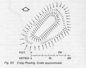
Craig Phadrig – Vitrified Fort Region : Scottish Highlands District : Inverness Town or village : Inverness Grid Reference : NH 640 452 Period : 500 BC-AD 600 Craig Phadraig is a hilltop fort within a Forestry Commission plantation, 2.5km west of Inverness. It occupies a position with excelent views over the Beauly Firth. The …