

The Cleave dyke system is several Dykes which combine to create a boundary of between 9 and 18 kilometres running north south to the west of Thirsk.
The Cleave dyke system is several Dykes which combine to create a boundary of between 9 and 18 kilometres running north south to the west of Thirsk.
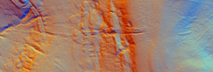
Black Dike is the diminutive counterpart to the great Tor Dike, rising from its western arm and climbing to the watershed between Great and Little Whernside. Beginning at roughly SD 988 756—where Tor Dike cleaves the limestone scarp—the Black Dike pursues a steep, sinuous course uphill for nearly 0.6 km, finally spilling onto the ridge crest at about 675 m above sea level
Jun 27

A gazetteer of probable prehistoric mounds, cairns and boundary earthworks in Coverdale. It is not complete and is still being researched.
Jun 15
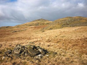
On every late-Victorian and early-20th-century OS sheet the surveyors marked any conspicuous heap of stones they could not instantly classify as a tumulus, beacon, trig-point or boundary stone with the catch-all term “Pile of Stones.”

The Kilburn White Horse is a large chalk hill figure cut into the limestone of Roulston Scar, the steep escarpment that defines the western edge of the Hambleton Hills in North Yorkshire. Carved in November 1857 and measuring roughly 97 by 67 metres, it was conceived not as an ancient relic but as a deliberate Victorian creation
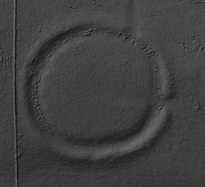
Castle dykes it is a small class one henge, 90m across, perched on the high ground up in the North Yorkshire dales. The bank survives up to 1.5 m high in places, and the ditch up to 3 m deep. Early 20th-century reports (1908) noted its intact form, and recent LiDAR-based surveys have confirmed its classic henge profile with minimal later disturbance.
Jun 11

These are raised platforms created first and foremost for cult, procession, assembly or conversion—not for fortification or routine boundary-making. They tend to be much more significant and monumental than other mounds and raised platforms. Some are the largest structures known of their type. In Britain, possibly the best known example is Silbury Hill in Wiltshire.
Jun 11
These are artificial hills made from the unwanted rock, shale and tailings that come up with coal, metal ore, stone or clay when it is being mined or quarried. Because extractive industry is both deep and long-lived, single collieries or pits can generate tens of millions of cubic metres of spoil; pushed out by locomotive, conveyor or tippler wagon and dumped in successive layers, the piles quickly become a distinctive landform.
Jun 10

Guide: Common Features of Iron Age Hillforts This article attempts to serve as a guide for many of the features of the hillforts found in Britain, in Read more Guide: Iron-Age minting: Ceramic Pellet-mould trays This article explores the most tangible evidence we possess for indigenous minting north of the Humber: the smashed ceramic “pellet-mould” …
Jun 10
A barrow is a mound of earth and/or stones raised over a grave or group of graves. Used from the Neolithic through to the Iron Age (roughly 4000 BCE to 500 CE), barrows were often constructed to honour elite individuals, such as tribal leaders, warriors, or chieftains. They are frequently found singly or in cemeteries known as barrow fields.
 NLS Map Explorer
 Google Earth
 Google Maps
 Lidar Finder
 TMA
TMA
 Megalithic Portal
 Yorkshire Arch. Air Mapping
 ADS
ADS
 Brigantian Adventure FB Group
Stone Bothering FB Group
Stone Faces FB Group
Brigantian Adventure FB Group
Stone Bothering FB Group
Stone Faces FB Group
 Heritage Gateway
 ARCHI® MAPS: UK
 Atlas of Hillforts
 Portable Antiquities
 British History Online
Brigantes Nation FB Group
British History Online
Brigantes Nation FB Group

