Category: Earthworks

Guide: Classification of Henge Monuments

Avebury Landscape

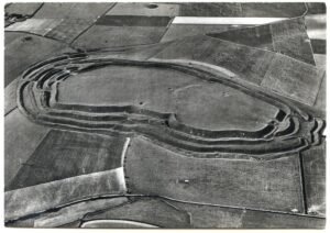
Archaeologists use the word “henge” for later-Neolithic and earliest Bronze-Age earthen rings whose ditch lies inside the bank, creating a deliberately bounded interior. The term itself was coined in 1932 by Kendrick; it was refined in the 1950s by Richard Atkinson, whose system still frames most discussion.

Moulton Henge

Moulton Henge - 1m Lidar

Archaeologists now recognise a true Neolithic henge lying immediately south-west of Moulton village, roughly midway between the Swale and Dere Street. The monument is almost 200 m across, with a low earthen bank encircling an inner ditch and a central platform about 110 m wide; the ditch lies inside the bank—the classic “Class II” henge arrangement.

Guide: Common Features of Iron Age Hillforts

Maiden Castle, Dorchester, Dorset

This article attempts to serve as a guide for many of the features of the hillforts found in Britain, in particular. It explains the basic elements of the design and architecture of a hillfort.

Guide: Fortified Barns in Yorkshire – A historical overview

Monastic Fortified tythe barn in Wenseydale

Even in a rural community of mainly farmers, there are often reasons to wish to build or create a structure that is for, at least in part, for defensive purposes. Thus, some barns in Yorkshire and other places can be seen to have “arrow slits”, and later, square “gun ports”. This article provides a brief overview of what these structures are, why they were built and how they were used.

A short history of coal-mining in Coverdale

Mine Flue Tunnel

Coverdale never possessed the thick, profitable seams that powered the great Yorkshire coalfield; instead it sat on the very feather-edge of the Yoredale Series where thin coal bands (18 – 50 cm) lie between the well-known limestone, sandstone and shale rhythms.

West Scrafton – Coverdale

West Scrafton

West Scrafton is a village located in Coverdale in the Yorkshire Dales. It sits on the southern upward slops of Coverdale, and had its most recent heyday in the 19th century when coal mining took over the village.

Brough Law, Breamish Valley, Northumberland – Bronze Age Terracing

Summary and supplemental information in relation to the publication: Early‐Middle Bronze-Age Agricultural Terraces in North-East England: Morphology, Dating & Cultural Implications.

Flats Hill – Carlton in Coverdale

Flats Hill Mound - Carlton-in-Coverdale - view from road

Flats Hill mound is approximately 30 meters in diameter and stands about 3.6 meters high. It has never been excavated, although a dry stone wall seems to have been started, and then stopped, partly over its top. It has been suggested as, and is listed as a probable barrow, with a presumably wide date, likely to be in the Bronze Age or Iron Age date range.

Round Hill Motte at Carlton-in-Coverdale

Motte_at_Carlton_in_Coverdale_-_geograph.org.uk_-_Gordon_Hatton

Carlton Castle, or Round Hill Motte, at Carlton-in-Coverdale is an intriguing historical site that offers a glimpse into the medieval past of the Yorkshire Dales. The structure seems related to an extensive set of linear earthworks that have been interpreted as agricultural, however, their existence asks a question: if these are not older than this medieval interpretation. 

Guide: The Ard – Early Ploughing in English Brigantia

Single Tyne Plough, Arba Minch

The ard, also known as a scratch plough, represents one of the earliest forms of agricultural technology used by the people of ancient Brigantia.

Contact Us
close slider