Notice: Function WP_Scripts::add was called incorrectly. The script with the handle "datatables-responsive" was enqueued with dependencies that are not registered: datatables. Please see Debugging in WordPress for more information. (This message was added in version 6.9.1.) in /home/u621095157/domains/brigantesnation.com/public_html/wp-includes/functions.php on line 6131
"We were shocked to discover such a huge complex," said Alastair Oswald, archaeological field investigator for English Heritage. Preliminary examinations Read more
This is our master collection page for all of our heritage articles and sites. It is the root of our Read more
Tor Dyke can be seen traced by the full length of the wall seen in the picture, it extends the natural escarpment of Cam Head which can be seen to the far left. This view is from the eastern side looking west.
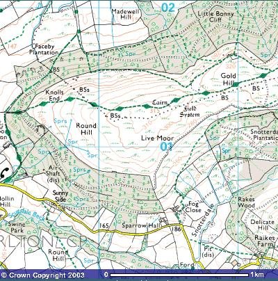
Tor Dyke (sometimes spelled Tor Dike) is a substantial linear earthwork cutting across the head of the Coverdale valley from Kettlewell in Upper Wharfedale, North Yorkshire. Stretching for just over two kilometres between grid references SD 9722 7549 and SD 9903 7535, it occupies a strategic ridge-neck that controls the only easy passage down from the moorland plateau into the sheltered dale below (outofoblivion.org.uk, heritagegateway.org.uk).
Introduction
"Around AD70 the rebel Brigantian Chief Venutius built the ditch of Tor Dyke close to Great Whernside as part of a defence system against Roman invasion. Despite a hold on other areas, (including Ingleborough and Gregory Scar north of Grassington), Venutius and his forces were overcome by the Romans." This reference was taken from one of Mike Harding's walking guides. A site visit to Gregory Scar has been performed, and although it has been dubbed "Fort Gregory" by the Dales Park Authority it does not appear to be much more than a small, very unusual settlement.
Tor Dyke appears to have been attributed to Venutius which dates it of the period AD 52 - 70. The presence of a legionary size marching camp a few miles to the southwest at Malham certainly indicates an active role in the Roman advance of AD 70. However, given the lack of published research so far a clear picture has yet to emerge.
Summary
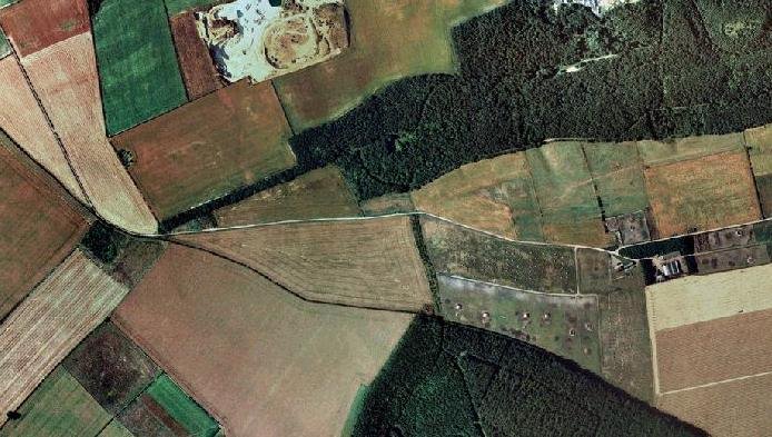
The above multimap air photo shows the huge scale of Tor Dyke, it stretches almost the entire width of the photo. To the right, almost at the end of the visible works is the entrance shown in the photo's below.
Geology
Geologically, Tor Dyke takes advantage of the Great Scar Limestone escarpment of the Askrigg Block. Here, the hard Carboniferous limestone forms a steep Scarp backed by gently dipping Yoredale beds. Rainfall percolates into joints and fissures in the limestone, producing a classic dry-valley landscape on the moor above, while the talus-covered foot of the escarpment drops sharply into the wooded valley head. This natural topography offered a defensible line, which the builders enhanced with an artificial rampart and ditch (commons.wikimedia.org).
Hill Fort
Tor Dyke is a large escarpment type hill fort a 2Km stretch of man - enhanced fortification links with natural escarpment to create a 3+Km defensive rampart.
This earthen dyke served not only as a fortification but also delineated territorial boundaries in the early establishment of the region known as Craven. Over time, Tor Dyke's role evolved; it became a boundary marker for Scale Park, a medieval hunting park frequented by nobility, including Charles II.
The landscape around Tor Dyke is marked by the survival of prehistoric and Romano-British farming landscapes, with evidence of extensive farming since at least the Bronze Age. The area is dotted with Bronze Age burial Cairns, adding to the historical tapestry of the region.
The earthwork itself comprises a single bank—constructed of limestone rubble and earth—up to 1.5 m high and several metres wide, paired on its downhill side with a flat-bottomed ditch approximately 4–6 m across. Beyond the ditch, a counterscarp bank of lesser height completes the profile. In places the builders exploited natural gullies or outcrops, cutting the ditch directly into bedrock; elsewhere they carried the embankment on turf-faced revetments to achieve a continuous defensive barrier (themodernantiquarian.com).
Although long attributed to the Brigantes as a pre-Roman frontier against Roman advance, current scholarship regards Tor Dyke as more likely the north-eastern boundary of an early medieval polity—possibly the Anglian kingdom of Craven—dating its construction to the Dark Ages (5th–9th centuries AD). Nevertheless, Iron-Age pottery sherds and hut-circle remains abutting the rampart hint at earlier enclosure activity, suggesting that the line may have been re-used or reforged by successive communities (themodernantiquarian.com, heritagegateway.org.uk).
In the medieval period, the dyke is thought to have marked the limits of monastic estates and was integral to the movement of goods and people, particularly wool, which was a significant commodity during that era. A further point to note is that it also marked the boundary to a significant hunting park, with many local landmarks seemingly renamed to that end. Hunters Stone, nearby, an example of this. The dyke's historical significance is further highlighted by its association with the Dark Age kingdom of Craven, serving as a boundary between Anglian invaders and native territories.
Location
Tor Dyke is close to Kettlewell in the Yorkshire Dales. OS Landranger 98 1:50,000 ref. 986756
Getting there
The narrow road from Kettlewell to West Witton cuts right through Tor Dyke about 4 Km north of Kettlewell. Immediately after cutting through the dyke the grass verge by a Cairn is good for parking. A clear footpath travels the whole length of the fortification. For the best effect, a climb up Great Whernside is not as hard as it looks. The site is always muddy and boggy, although the footpath in the main is free from serious boggy bits.
Warning - Shake holes
The area is strewn with shake holes, which are the remains of mining from later periods. In some cases, these are very deep, have steep sides (usually conical) and are filled with water.
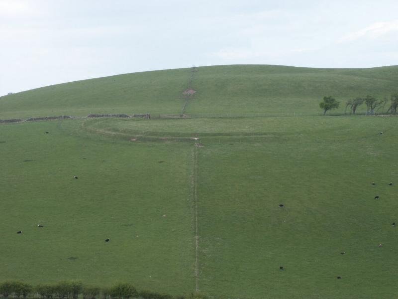
On the east side the main entrance is to be found. The way in from the south is to the left of the picture.
Another view of the entrance, to show possible additional ditch heading south.
This view shows the eastern side of the defences, they follow the wall almost to the point where it takes a sharp left turn to head up Great Whernside. This is an obvious weak spot, and it may have had additional defensive works.
Following the rampart towards the western side, in places outer defensive ditches can still be seen to an approximate depth of 2m. This indicates a possible original depth of 6m. Width estimated at 6m.
Principal archaeological finds
A full, stand-alone monograph on the Iron-Age material from Tor Dyke hasn’t been published, but the principal archaeological finds and their interpretation are summarized in a handful of key reports and articles:
Historic England PastScape Record
Entry No. 309831 (“Tor Dyke, earthwork, boundary bank and ditch”).
Includes a concise summary of all recorded finds (chiefly Iron-Age pottery sherds from fieldwalking and surface collection) and points you to the primary reports in the YAS (Yorkshire Archaeological Society) archives.
Sharples, N. (1988), “Tor Dyke, Coverdale: Topographic Survey and Pottery Analysis,” in Proceedings of the Yorkshire Archaeological & Historical Society, 60, pp. 45–62.
Presents the detailed earthwork survey, quantifies the c. 30 sherds of South Pennine “Decorated Ware,” and places them in a mid–Late Iron-Age context (4th–1st century BC).
Discusses distribution of finds along the rampart and ties them to small homesteads abutting the dyke.
Lambrick, H. T. (1992), “Tor Dyke and its Hinterland: A Re-assessment,” in Landscape History, 14, pp. 21–34.
Re-evaluates the Iron-Age evidence in light of new radiocarbon dates from nearby hut-circle excavations, confirming the dyke’s reuse as a territorial boundary.
Yorkshire Archaeological Trust Reports
The YAT holds the original trench-log and sherd-illustrations from the small 1974 evaluation trench. Ask their library for “Site Code 74/TD1.”
Swaledale & Arkengarthdale Archaeology Group Bulletins
Although SWAAG’s 2011 geophysics focused on later phases, their annual newsletters (2012–2015) append a short section reviewing earlier Iron-Age finds at Tor Dyke, with measured drawings of rim-shapes and fabric descriptions.


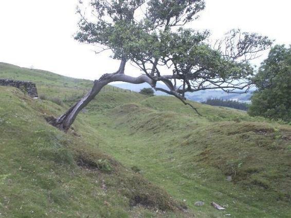


 Tor Dyke can be seen traced by the full length of the wall seen in the picture, it extends the natural escarpment of Cam Head which can be seen to the far left. This view is from the eastern side looking west.


