

Contents
- 1 An introduction to Bishopdale
- 1.1 Geology and Geomorphology
- 1.2 Geography, Drainage and Settlement
- 1.3 Heritage Farmsteads and Built Landscape
- 1.4 Prehistoric Burial Monuments
- 1.5 Neolithic and Bronze Age Landscape Use
- 1.6 Iron Age and Medieval Enclosures
- 1.7 Conservation and Visitor Interpretation
- 1.8 Visitor Attractions
- 1.9 How Bishopdale Got Its Name
- 1.10 Land Ownership from 1066 Onwards
- 1.11 Economy and Occupations
- 1.12 Links with Wensleydale
- 1.13 Castle Bolton
- 1.14 A cluster of Follies
- 1.15 Penhill Preceptory
- 1.16 Temple Lane

This area of Wensleydale has quite a significant number of follies, and not far from The Temple Folly, we have Read more

The Tower, approximately 100 metres to the north-east of Bolton Hall, close to Wensley village. It was built in the Read more

Bolton Hall, a stately country house in the Yorkshire Dales, has a rich history that intertwines with the broader narrative Read more

Bolton Castle, an ancient fortress located in the heart of Wensleydale, Yorkshire, stands as a testament to medieval architecture and Read more

Even in a rural community of mainly farmers, there are often reasons to wish to build or create a structure Read more

Prehistoric Yorkshire is a landscape rich with history, revealed through various archaeological finds that offer a glimpse into the ancient Read more
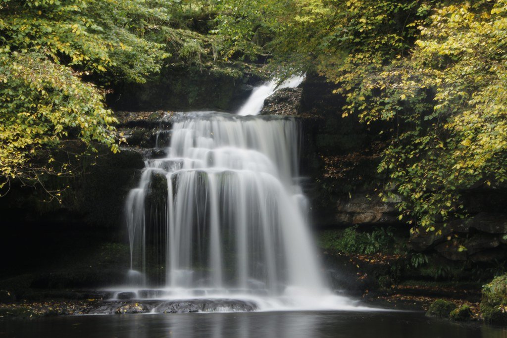
"West Burton Falls" by ejwwest is licensed under CC BY-NC-ND 2.0
An introduction to Bishopdale
Geology and Geomorphology
Bishopdale lies within the northern limb of the Askrigg Block, its underlying bedrock dominated by Carboniferous limestones with intermittent Shales and sandstones of the Yoredale Series. The Great Scar Limestone, a thick, massive unit formed around 330 million years ago in a shallow tropical sea, underpins the dale’s steeper scarps and cliff lines, while the thinner-bedded limestones and intervening mudstones of the Yoredale Group create the characteristic terraced flanks on which many of Bishopdale’s field systems are laid out (en.wikipedia.org, yorkshiredales.org.uk). Pervasive jointing in the limestones has allowed rainwater to percolate away, promoting a classic karst landscape of dry valleys and sink features, though Bishopdale itself drains via surface streams into the Ure system.
Glacial Legacy and Valley Form
During the Devensian glaciation (c. 115 000–11 700 BP), ice flowing eastward sculpted Bishopdale into a classic U-shaped valley, scouring the bedrock and infilling its floor with glacial till. As the climate warmed, meltwater incised the till to form the sinuous course of Bishopdale Beck, while tributaries from the surrounding fells cut steep side gills and created tongue-shaped Moraines at tributary junctions (cag.bcra.org.uk, en.wikipedia.org). The dale’s floor remains carpeted with those glacial deposits, providing a fertile base for the dale’s pastoral land use and preserving the subtle traces of ancient settlement features that lie just below the plough zone.
Geography, Drainage and Settlement
Extending some six miles southwest from Aysgarth, Bishopdale is one of the quieter side dales of Wensleydale. Its principal watercourse, Bishopdale Beck, rises at Causeway Moss on the ridge with Wharfedale and winds north-eastward for about 15 km until joining the River Ure east of Aysgarth (en.wikipedia.org). The B6160 follows the beck for most of its course, linking the three small villages—West Burton, Thoralby and Newbiggin—that cluster in the dale’s lower third. Above them, the dale narrows into pastoral enclosed fields and isolated farmsteads, reflecting a landscape shaped by both tenurial consolidation and the eighteenth-century drive for improved agricultural yields.
Heritage Farmsteads and Built Landscape
Though Bishopdale contains no major settlements, its built heritage is represented by several notable farmhouses dating from the 17th and early 18th centuries. Smelter Farmhouse, perched on the steep northern flank of the dale, dates to 1701 and is named for a medieval smelting hearth discovered nearby; it survives with its original moulded door surround and mullioned windows under a stone-slate roof (en.wikipedia.org). Lower down, Longridge Farmhouse (1653) displays a two-storied porch bearing dated inscriptions and retains an outbuilding once part of its original plan; both structures speak to the dale’s continuity of upland farming and the relative wealth of its tenants during the post-medieval era (en.wikipedia.org).
Prehistoric Burial Monuments
The upper slopes of Bishopdale preserve the remains of Bronze Age funerary practices in the form of Round Barrows. One such mound, long known locally as “Boadicea’s Grave,” measures some ten feet in height and forty yards across, ringed by a shallow ditch and thought to date to around 2000 BC (thejournalofantiquities.com). Although never fully excavated in modern times, antiquarian accounts and limited field surveys suggest at least three Barrows are clustered near the summit ridge, implying the existence of a small, multiphased cemetery and indicating the dale’s role as a ritual landscape overlooking the wider Wensleydale valley.
Neolithic and Bronze Age Landscape Use
Evidence for Neolithic activity in Bishopdale is much rarer, reflecting the dale’s upland setting and later alluviation. However, broader regional studies identify long Cairns and oval mounds on ridge tops in neighbouring dales, suggesting seasonal or ritual visitation during the fourth millennium BC. Within Bishopdale itself, paleoenvironmental coring of peat deposits at the head of the dale has recovered cereal pollen and charred wood fragments consistent with small-scale clearance and woodland management during the Late Neolithic–Early Bronze Age transition (academia.edu, projects.digventures.com). These data hint at a landscape gradually opened for pastoralism, with funerary monuments serving as territorial markers in an emerging agrarian society.
Iron Age and Medieval Enclosures
During the Iron Age (c. 800 BC–AD 43), the dales of North Yorkshire saw the establishment of small Promontory forts and defended farmsteads. While Bishopdale lacks a classic hillfort, cropmark surveys and LiDAR mapping have revealed traces of at least two enclosed settlements on elevated knolls above the dale floor, dated by residual pottery sherds and a single radiocarbon date to the second–first centuries BC (projects.digventures.com). In the later medieval period (c. 12th–15th centuries), the dale’s farmsteads coalesced into the patterns still visible today, with charters referencing landholdings at Smelter and Longridge tied to the barony of Middleham. Agricultural hearths and small field barns from this era, recorded in Historic England surveys, confirm an intensification of pastoral management under the manorial system.
Conservation and Visitor Interpretation
Today, Bishopdale’s blend of geological spectacle, glacial landforms, heritage farm buildings and archaeological monuments make it a microcosm of the Yorkshire Dales National Park’s story. Public footpaths traverse the dale from Aysgarth Falls to Kidstones Pass, offering walkers interpretive panels on the dale’s geology and ancient barrows. Conservation efforts by the Yorkshire Dales National Park Authority and local river trusts seek to balance habitat restoration in the beck corridor with the Preservation of field patterns and dry-stone walls that date back to the medieval enclosure movement (en.wikipedia.org, en.wikipedia.org).
This review of Bishopdale reveals a landscape shaped by deep-time geological processes, punctuated by glacial transformation, and continually re-fashioned by human hands—from prehistoric communities marking their dead on the ridge tops, through Iron Age settlers enclosing their homesteads, to medieval and post-medieval farmers whose stone-built legacies still stand. The dale’s archaeology and heritage, set within its dramatic karst terrain, offer a richly layered testament to over four millennia of human engagement with the Yorkshire Dales.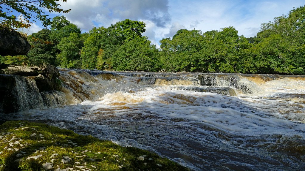
"Aysgarth Lower Falls" by ARG_Flickr is licensed under CC BY 2.0
Visitor Attractions
Bishopdale’s quiet charm belies a wealth of attractions, from dramatic waterfalls to tranquil upland pastures and centuries-old farmsteads. For many visitors, the first stop is Aysgarth Falls, where a series of three broad limestone ledges carries Bishopdale Beck into the River Ure. Although technically in Wensleydale proper, these falls lie just beyond Bishopdale’s mouth and are easily reached via a short walk from West Burton—offering rugged scenery that has inspired painters and featured in film (yorkshiredales.org.uk).
Within the dale itself, the village of West Burton is famed for its double green—reputedly the largest in England—flanked by a medieval market cross and stocks, and anchored by the Cat Pottery, a family workshop crafting its whimsical garden ornaments since 1982 (dalesdiscoveries.com). A little higher up, the Newbiggin Pastures Nature Reserve protects flower-rich meadows and upland grasslands, offering gently graded trails and expansive views toward Kidstones Pass (ywt.org.uk). Hikers seeking panoramic vistas can follow the bridleway over Kidstones Pass, which at 602 m links Bishopdale to Upper Wharfedale and rewards walkers with sweeping ridge-top panoramas.
For those drawn to antiquity, the upper dale’s Bronze Age barrows remain visible as low, turf-covered mounds on the skyline. Although they have never been fully excavated, these monuments—known locally by names such as “Boadicea’s Grave”—mark a prehistoric ritual landscape that once overlooked all of Wensleydale. Nearby, the slopes above West Burton preserve the Iron Age hut circles of Burton Moor, scheduled as ancient monuments and detectable on wintery days when low sun brings out their turf-lined gullies.
Lower down, two of Bishopdale’s most striking heritage farmhouses—Longridge (dated 1653) and Smelter (1701)—offer intimate glimpses of the dale’s post-medieval economy and architecture, both surviving with mullioned windows, stone-slate roofs and original inscriptions that speak to centuries of upland tenancy and sheep-farming prosperity (en.wikipedia.org, en.wikipedia.org).How Bishopdale Got Its Name
Despite its ecclesiastical ring, Bishopdale does not seem to commemorate a medieval bishop’s demesne. Instead, the earliest records suggest the name derives from an Old English personal name Biscop, marking “Biscop’s valley,” and only later became folk-linked to bishops and the church (thoralbythroughtime.net).
Land Ownership from 1066 Onwards
At the time of the Domesday Survey (1086), the manor of what is now West Burton belonged to an Anglo-Scandinavian lord named Thorkil. In the aftermath of the Conquest, Count Alan of Brittany received vast swathes of Yorkshire, granting Burton and its upland chase to his follower Geoffrey of Swaffham (komoot.com). Over the medieval centuries, the wide stretches of Bishopdale formed part of the deer-chase held by the Lords of Middleham, prized for its summer grazing and hunting. By the early 1600s, however, that chase had been broken up: ownership passed first into the hands of London citizens and then, farm by farm, into the hands of the very yeomen who had long tilled its fields under tenant-right (thoralbythroughtime.net).
Economy and Occupations
Bishopdale’s economy for much of its history has revolved around two main activities: upland pastoral farming and the extraction of lead, each leaving distinctive marks on the dale’s appearance and heritage.From the earliest clearance of woodland in the later Neolithic and Bronze Age, Bishopdale—and the wider Yorkshire Dales—was shaped by grazing livestock. Pollen records from peat and alluvial deposits at the head of the dale attest to small‐scale cereal cultivation alongside managed woodland, but it was the switch to pastoralism that endured.
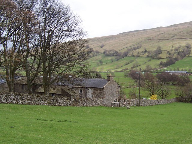
"Howesyke Farm, Bishopdale - geograph.org.uk - 159733" by Chris Heaton is licensed under CC BY-SA 2.0
Farming
By the medieval period, open fields and summer pastures (“vaccaries”) higher on the fells supported transhumant herds of cattle and, increasingly from the 15th century onwards, flocks of sheep driven up for their fine wool. Under the manorial system, tenants paid dues in kind, and the dale’s dry‐stone walls, field barns and narrow strip fields date largely to this era of intensified grazing and tenurial consolidation. With 18th- and 19th-century agricultural improvements—enclosure acts, lime‐spreading on the Yoredale limestones and the introduction of hardy longwool breeds—sheep farming became dominant, transforming the dale floor into a patchwork of enclosed pastures and leaving only traces of its earlier arable and mixed‐farming origins .
Mining
In parallel, Bishopdale’s subsurface geology—thick Carboniferous limestones cut by mineral veins—has hosted lead mining from at least the Roman period. Artefacts such as pig‐lead stamped with Emperor Trajan’s name (c. AD 117–138) confirm early exploitation, and the dale’s first documented smelting hearth may date to 1657 at what became Smelter Farm—indeed, its name preserves that industrial heritage (yorkshiredales.org.uk, yorkshiredales.org.uk). By the late medieval period, small‐scale mining at Bishopdale Gavel produced lead ore into the 14th century, and the introduction of water‐powered smelt mills in the 16th and 17th centuries allowed more efficient processing of galena. Large‐scale mining persisted through the 18th and into the 19th century, with Bishopdale Gavel Mine finally closing in 1871. These operations cut “hush” gullies on steeper ground, created spoil‐heaps on moorland slopes, and left scheduled ruins of levels, battery sites and flue fragments that still pock the landscape (nmrs.org.uk, buddlepit.co.uk).
The dual imprint of farming and mining can still be read in Bishopdale’s contours. Shepherds’ barns and walls form regular grids on the dale floor, while the higher slopes carry the scars of mineral workings—linear mounds of waste, collapsed adits and occasional drystone platforms where ore was crushed. Soil around these features often shows elevated lead levels, restricting vegetation to metal-tolerant species. Conversely, the fertile till and alluvium of the valley bottom support lush pastures, punctuated by mature hedgerows along the old drove roads once used to move sheep and cattle to market.
Decline of Lead Mining
With the decline of lead mining after 1871 and the mechanization of agriculture in the 20th century, many of the dale’s farmsteads were abandoned or consolidated, and a program of landscape restoration has sought to balance conservation of industrial monuments with protection of habitats. Today, walking trails guide visitors past both the neat enclosure patterns of centuries-old sheep farms and the weathered remnants of Bishopdale’s smelting past—reminding us how, for over two millennia, people have carved livelihoods out of both livestock and the rocks beneath their feet.Links with Wensleydale
An interesting link with Wensleydale, is that Castle Bolton is positioned so that it can see the southern entrance to Bishopdale, many miles to the south, and this seems to be a strategic decision to its construction.
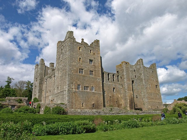
"Bolton Castle, at Castle Bolton - geograph.org.uk - 1390969" by wfmillar is licensed under CC BY-SA 2.0
Castle Bolton
Castle Bolton’s siting speaks volumes about medieval strategic thinking in Wensleydale. Perched high on a rocky outcrop overlooking the northern bank of the River Ure, the castle commands an uninterrupted line of sight southward along the valley floor. From its battlements, on a clear day one can discern the narrowing of the dale where Bishopdale Beck joins the Ure—precisely the gateway through which any traffic, be it friendly traders or hostile raiders, would have to pass, more than this, at the southern end of Bishopdale, its entrance is also visible, meaning all visitors could be counted in, and counted out.
When Sir Richard le Scrope rebuilt the castle in the 14th century, he was fortifying his control over the entire upper dale network. By placing Bolton so that its watchmen could observe both the Wensleydale “main road” and the subsidiary route into, and out of Bishopdale, he ensured advance warning of movements in either direction.
This dual oversight dovetailed with the castle’s function as an administrative centre: tolls, markets and judicial courts were all regulated here, and any dispute over upland pastures or lead‐working rights in Bishopdale could be monitored from the same perch that oversaw the vale beyond.
Archaeological surveys of the surrounding hillside reveal a clear “sighting corridor” marked by ridgeline field boundaries and fragments of medieval drove‐roads. These features, now faintly visible only in LiDAR data, trace the path of Packhorses and drovers who would have come under the castle’s gaze as they ferried wool and ore toward market towns. In this way, Bolton’s builders harnessed geography—ridge alignments, natural escarpments and valley constrictions—to create a vantage point that was both symbolically and practically central to regional governance.
A cluster of Follies
Along the northern edge of Bishopdale, just before the valley opens into Wensleydale, a cluster of eccentric “folly” monuments crowns a craggy limestone outcrop.Pepperbox, The Rocket, and the Guillotine
Here, Victorian and later landowners—and finally local enthusiasts—erected a sequence of whimsical structures that transform a simple ridge into a miniature “fantasy landscape.” The best-known of these is the so-called Pepperpot (sometimes “Pepper Box”), a stout circular stone tower rising some twenty feet above the rock. Built in 1887 by a local gentleman named Bowskill to mark Queen Victoria’s Golden Jubilee, it stands as a visual punchline to its own nickname: a pepper pot domineering the dale (beatingthebounds.wordpress.com).
Nearby, a crude rocket ship—a galvanized-steel mock-up of early 20th-century space-age dreams—and what looks like a guillotine blade, painted steel set atop a rough timber frame, offer a tongue-in-cheek counterpoint to the Pepperpot’s genteel folly. These later additions, probably installed in the mid-20th century by local walkers or artists, playfully riff on the idea of “landscape ornament” by juxtaposing rural antiquity with modern iconography (dalesdiscoveries.com).
Temple Folly
A little to the north-east, in a small woodland clearing, stands the Temple Folly, an elegant octagonal belvedere erected in 1792. Perched on its own amid coppiced trees, the Temple Folly was built by the owners of the nearby Aysgarth estate as a sheltered summerhouse and viewing pavilion. From its upper gallery, late-18th-century visitors—gentlefolk in frock coats and flowing gowns—could survey the wooded dale and the distant battlements of Bolton Castle. Today it survives as a Grade II listed building, its ashlar stonework and Doric columns a reminder of the Romantic era’s taste for “picturesque” landscape features that blended architecture and natural scenery (yorkshiredales.org.uk).
"Templars Chapel, near Aysgarth, Wensleydale" by colgregg is licensed under CC BY 2.0
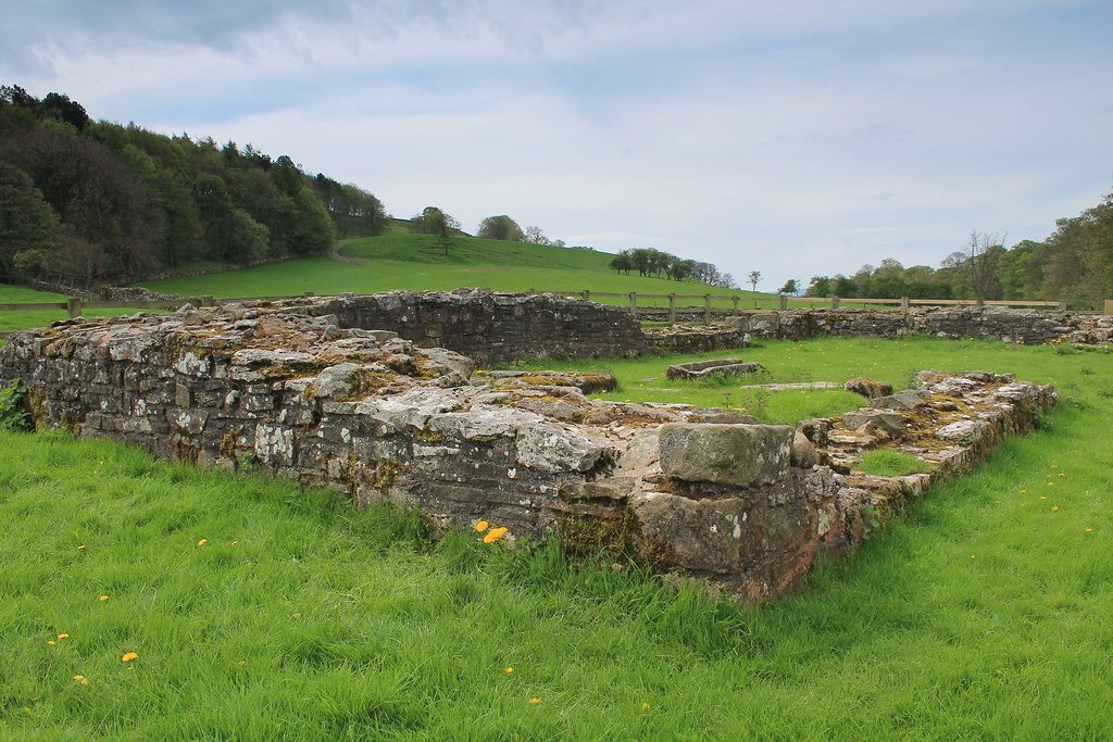
Penhill Preceptory
Perched on the spur of Penhill above West Burton, the preceptory was founded in the early thirteenth century (c. 1200–1210) as part of the Templars’ network of Yorkshire estates. Its precinct occupied a roughly rectangular enclosure, defended by low earth banks and a slight ditch, and would originally have contained a small chapel, domestic ranges and ancillary buildings clustered around a central courtyard. A fishpond just below the site supplied the community with fresh freshwater fish, while ridge-and-furrow fields to the east provided grain for sustenance.
By 1308, when the crown suppressed the Templars, Penhill passed to the Knights Hospitaller, who maintained a reduced presence here until the Dissolution of the Monasteries in the 1540s. After that it reverted to local lay landlords and gradually fell into ruin. Today you can still make out the platform of the chapel—an elongated mound some 25 m long—and the shallow remnants of its enclosing bank, while the former fishpond survives as a wet hollow cloaked in reeds.
Temple Lane
Temple Lane, the old causeway up from the south of the dale to West Burton, almost certainly served as the preceptory’s main access route, linking it both to the dale below and to a Templar docking place on the River Ure, where grain tithes and wool might be shipped out. These earthworks and hollow ways testify to a once-thriving religious and economic centre that knit Bishopdale into the wider medieval order of the Templars and later Hospitallers.
If you’d like, I can sketch a plan of the surviving earthworks or dive deeper into the preceptory’s documentary record and its post-Dissolution history.


