Map Icon: Hill Fort

Castro de Trona fort – Pontevedra, Spain

Petroglifo castro Troña

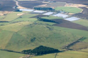
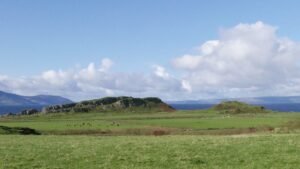
Castro de Trona is an oval enclosure with significant terracing to the west and a large ditch to the east. This castro (a hillfort settlement) has an accepted date of around 600 BCE. Like many others in Galicia, this castro reached its peak during the 1st and 2nd centuries CE. It measures approximately 200 metres east to west by 150 metres north to south.

Great Roe Wood (Roe Wood) Enclosure – Woodhouse

Great Roe Wood - Sheffield - OS Series 1

Great Roe Wood (often simply called “Roe Wood”) sits on the Magnesian Limestone ridge that carries the Roman Rig between Sheffield and Doncaster, just northeast of the village of Woodhouse (OS grid SK 450 920). This ridge forms a natural corridor overlooking the Don valley, with shallow soils over limestone giving way to deeper alluvial gravels in the valley bottom.

Wincobank Hill Fort

Wincobank Fort – LiDAR – National Library of Scotland 3

This is an oval fort with an internal area of 2.5 acres. A bank, ditch and counterscarp bank are continuous around it except on the N side where ditch and counterscarp have been destroyed.

Scoles Coppice Fort

Scholes (or Scoles) Coppice Camp (sometimes called “Caesar’s Camp”) lies just north-west of Kimberworth in Rotherham, atop the same Magnesian Limestone ridge that carries the Roman Rig. Its grid reference is roughly SE 436 937, placing it only 200–300 m to the north of the Rig’s northern branch

Tor Dyke

Tor Dyke appears to have been attributed to Venutius which dates it of the period AD 52 – 70. The presence of a legionary size marching camp a few miles to the southwest at Malham certainly indicates an active role in the Roman advance of AD 70. However, given the lack of published research so far a clear picture has yet to emerge.

Knockfarrel Fort

Knock Farril

This had substantial ramparts made of stones with a timber frame, enclosing a large area and making good use of the natural defences of the hill-top.

Mote of Mark Hill Fort

Mote of Mark from sea shore path

The Mote of Mark is a defended hilltop overlooking the Urr estuary. It was the court or citadel of a powerful Dark Age chieftain, possibly one of the princes of Rheged. The site was occupied during the 6th century and appears to have been destroyed by fire in the 7th century.

Barry Hill Fort

Hillfort on Hill of Barra, near Old Meldrum, from the air

Barry Hill is a textbook “big fort waiting for a small trench”: its spectacular vitrified rampart, enigmatic outer works and Arthurian folklore offer equal attraction to scientists and story-lovers—yet almost everything we know comes from surface survey. A single, well-designed excavation season could pivot the site from picturesque curiosity to a securely dated anchor point in the defensive story of eastern Scotland.

Dunagoil Hillfort, (Isle of Bute, Argyll & Bute)

Dunagoil Hillfort

Dunagoil crowns a 30 m-high columnar-basalt promontory on the south-west coast of Bute, overlooking the Sound of Bute and the Cumbraes. Cliffs on the north and west form natural ramparts; only the gentle ESE saddle gives easy access.

Tap O’Noth Hill Fort

Tap O Noth Hillfort

This is one of the best examples of a vitrified fort, it is near the village of Rhynie in northeastern Scotland. This massive fort from prehistory is on the summit of a mountain of the same name which, being 1,859 feet (560 metres) high, commands an impressive view of the Aberdeenshire countryside.

Contact Us
close slider