Votive inscriptions to the Goddess Brigantia have been found in the North of England using four names: Caelestis Brigantia, Nympha Read more
[zoom zoomin=”2″]
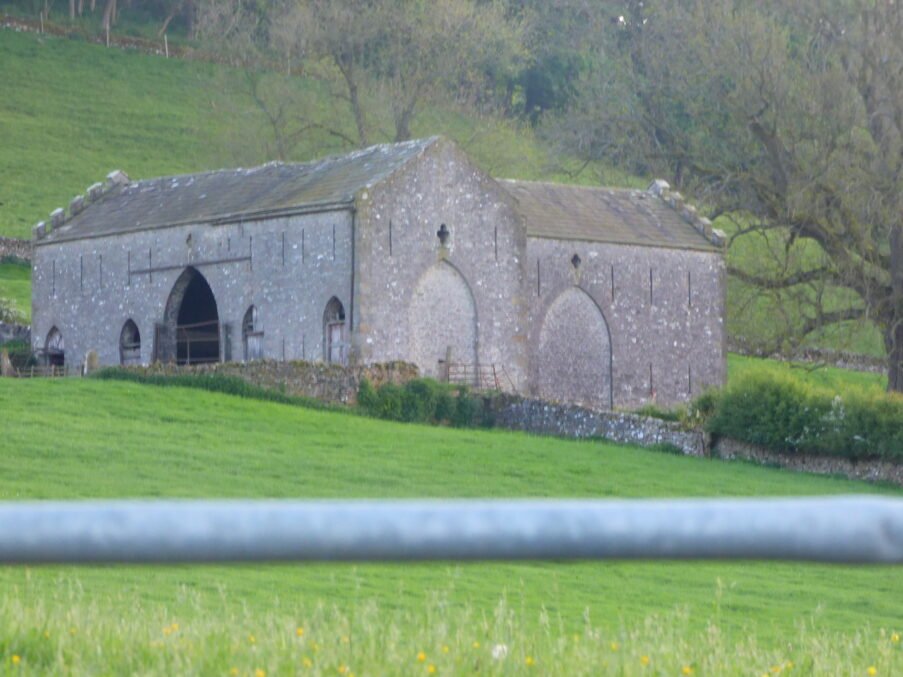
Fortified Barns in Yorkshire – an historical overview
Even in a rural community of mainly farmers, there are often reasons to wish to build or create a structure that is for, at least in part, for defensive purposes. Thus, some barns in Yorkshire and other places can be seen to have “Loopholes”, slots for arrows, and later, square “Musket-loops”. This article provides a brief overview of what these structures are, why they were built and how they were used.
Aspect
Key points
What counts as a “fortified barn”?
A rural building whose primary function remained agricultural (storing grain, fodder, animals) but that was given structural features intended to deter or resist attack:
Very thick masonry (0.8 – 1.2 m)
Small vertical loopholes for hand-guns/longbows
Few, defensible doorways
Sometimes an upper floor reached by an internal stair/ladder behind a stout door.
These differ from pele or tower houses, whose main role was domestic defence, and from monastic tithe barns built purely for storage.
Why fortify?
Border reiving (c. 1450 – 1603) – Scottish and Cumbrian raiders pushed deep into the Dales.
High-value cargoes – barns often stored tithes of grain, wool and cheese worth a year’s rent; protecting them reduced armed escort needs.
Main types seen in Yorkshire
Bastle-barns (or “bastle houses”) – hybrid two-storey blocks: ground-floor byre, upper living/feed floor; slit-loops at both levels. Found mainly in Upper Swaledale, Arkengarthdale, Dentdale, upper Teesdale.
Defensible monastic grange barns – huge aisled barns (e.g., Bolton Priory tithe barn) with arrow-loops or gun-loops in the end gables; built 14-15 c. by Cistercians to safeguard tithes.
Estate “munition barns” (late 16th – 17th c.) – single-storey threshing barns with loopholes flanking the cart doors; added when landlords remodelled stock-farms during the great sheep-boom.
Key architectural terms
Loophole / musket-loop – narrow vertical slit, often with internal splay
Bastle – from Fr. bastille; fortified farmhouse, common on the Anglo-Scottish border.
Put-log hole – square socket for timber scaffolding; often confused with loopholes.
Byre – cattle stall occupying ground floor of a bastle.
Distribution (Historic England & NY/Co Durham HER data)
There are c. 40 recorded bastle-type buildings in former North-Riding Yorkshire: clusters in Swaledale (Keld, Thwaite, Muker), upper Teesdale (Holwick, Bowlees), plus outliers in Dentdale and Langstrothdale (then West Riding).
6 large monastic tithe barns with defensive details (Bolton Abbey, Fountains, Jervaulx grange at Thornton Steward, Easby, Rievaulx, Mount Grace).
c. 12 estate barns with 16th-century gun-loops recorded across Coverdale, Wensleydaleand Nidderdale.
How the defences arose
Bastle-barns: built new 1580 – 1630 during peak reiver violence; reused as ordinary byre-barns once peace returned.
Monastic barns: loops integrated from the outset (14 – 15 c.), reflecting the Cistercians’ experience of local unrest and their need to protect stored tithes until collection.
Estate barns: landlords inserted loops when walling-up threshing door heads or rebuilding gables after raids; many loops have 17th-century mason’s marks.
Examples worth visiting / studying
Stang Side Bastle, near Keld – textbook two-storey bastle now a hay-barn.
Town Head Farm Barn, Muker – loops, 0.9 m walls, blocked stair-door.
Bolton Priory Tithe Barn – 55 m long, looped west gable.
Friar’s Head Grange Barn, Winterburn – estate munition barn with musket-loops flanking cart doors.
Scar House “Coal Barn”, Nidderdale – single-bay barn with three gun-loops, repointed in 18th c.
Research challenges & future work
Many loops are later ventilation slots—field survey must measure height, splay, and firing sills.
LiDAR & drone Photogrammetry can locate buried fore-buildings or wall-footings of vanished bastles.
Estate archives (leases, repair accounts) may distinguish between “cole barn” (fuel) and “shield barn” (defensible).
A systematic trawl could yet double the known tally.
Take-away
Yorkshire’s fortified barns are frontier solutions—piecemeal defences stitched onto agricultural buildings to ride out episodic violence, rather than the monumental tower houses of Northumberland. Two principal belts stand out:
The Dales bastle group guarding livestock on high moor edges
The monastic grange barns guarding ecclesiastical grain in lower valleys.
Their rarity (tens, not hundreds) makes each survivor a key witness to how ordinary farming communities hardened their working buildings when the borderlands ran rough.
The “Dales Bastle” Group – a closer look
Aspect
Detailed profile
Geographic spread
Concentrated in the upper valleys of Swaledale, Arkengarthdale, upper Teesdale, Dentdale and the highest reaches of Wensleydale and Langstrothdale. All sit above c. 300 m OD on or near open moorland edges—exactly where cattle were pastured in summer and most vulnerable to 16th-century reiver raids. GIS plotting of HER records shows two tight clusters:
Muker–Thwaite–Keld loop (c. 20 survivals/ruins).
Holwick–Newbiggin–Bowlees area (c. 10).
Outliers exist at Raisgill (Langstrothdale) and Cowgill (Dentdale).
Chronology
Mason’s mark series and dendro dates put construction mainly c. 1580 – 1630, the final decades of Border Reiving and the first decades after the 1603 Union of the Crowns, when raids persisted, but large-scale tower building had ceased. Occasional earlier origins (ca. 1520) are suspected, where ground floors have chamfered door surrounds. Many bastles had hay-barn conversions (loft removed, wagon door cut) 1750 – 1850.
Plan & dimensions
Rectangular block, 11–14 m x 6–7 m externally; walls 0.9–1.2 m thick in un-coursed rubble (local Limestone or Grit). Two-storey: lower byre with central drain, tether rings, and a vaulted or flat stone roof carrying an upper loft originally reached by internal newel stair behind a studded door. A single opposing cart-door pair is later; original entry is typically a narrow byre doorway with a draw-bar slot.
Defensive detailing
Loopholes: tall, narrow, sometimes with external chamfer; splayed to ~20 cm inside, cut 1.1–1.3 m above byre floor (firing from a crouch).
Murder-hole: small chute above the byre doorway, now usually blocked.
A vaulted byre ceiling (where present) creates a fire-proof fighting platform; more common in Arkengarthdale.
External stair to loft is always secondary; original access was internal to keep doors to a minimum.
Material culture & fittings
Few interiors retain original floors, but survey drawings note: tether stones, joist sockets for a raised timber hay loft, and carved sockets for a central post (supports granary bins). Re-use of arrow-slit stones from abbey ruins is recorded at Stang Side.
Function & social context
Not mini-castles but defensible farm-buildings: winter cattle below, fodder and sometimes family sleeping pallets above. Oral tradition in Swaledale says the family slept upstairs only during “bad riding nights” (full moon, snow pack). Bastles allowed upland graziers to stay near stock instead of driving herds to village paddocks nightly, and to safeguard tithe-wool and cheese until Pack-horses assembled for Richmond market.
Conversion & survival
About half the known bastles were heightened, windowed and slated as conventional hay-barns in the 18th c.; loopholes blocked or re-cut as ventilation slits. A quarter survive as ruins (roofless but walls to full height), and a handful—e.g., High Bulmer Tarn Bastle—are still roofed and used for fodder.
Diagnostic checklist in the field
– Walls ≥ 0.9 m thick.- Loopholes ≤ 10 cm wide, internal splay.- Byre doorway ≤ 1 m wide with draw-bar slot.- Evidence of former first-floor fireplace.- Moor-edge siting with view of approach routes.- No threshing floor (bastle ≠ threshing barn).
Key examples to visit or study
Stang Side Bastle, nr. Keld – intact two-storey, vaulted byre.
Town Head Farm Bastle, Muker – blocked loopholes, visible internal stair recess.
East Gill Force Bastle ruin, Swaledale – classic single-chamber ruin with loopholes.
Systematic LiDAR + photogrammetry of collapsed gables to confirm loophole counts.
Dendrochronology on 2nd-phase roof timbers to chart conversion wave.
Estate leases to map correlations between newly enclosed intakes (late 16th c.) and bastle construction.
Take-away
The Dales bastles are a tight-dated, upland spin-off of the wider Border bastle tradition—bespoke to defensive stock-ranching in remote valleys rather than feudal power-projection. Their distribution mirrors the most vulnerable summer pastures and long Pack-horse routes, and their later conversion charts the pacification of the border and the rise of specialist hay-barns and sheep-fold structures in the 18th century.
Distribution contrast: Dales Bastles vs. Estate-“munition” Barns
Dimension
Dales Bastles
Estate-barns with gun-loops (17 th–18 th c.)
Why the patterns diverge
Topographic setting
High-moor edges (≥ 300 m OD) overlooking summer-grazing intakes; usually within 500 m of open fell.
Valley-floor or lower‐slope grange farms (150–250 m OD), close to road junctions, bridges and limekilns.
Bastles protected cattle & fodder at risk where raiders struck first; estate barns guarded landlord tithe stores where cart access was essential.
Scattered singles or pairs across the main settled dales: Wensleydale (Redmire, Bainbridge), Coverdale (Coal Barn, Scar House), Nidderdale (Lower Scarr House, Ladebank), Wharfedale (Friar’s Head Grange). No tight cluster—distribution follows large estates’ core holdings.
Bastles = peasant/grazier response in a border no-man’s-land;Estate barns = landlord investment in improving demesne centres.
Road proximity
Often on hollow-ways or loft‐tracks rather than turnpikes; 200–800 m from main dale road.
Directly fronting Turnpike or river-bridge approaches; some within 50 m of roadside limekilns or tithe barns.
Estate barns doubled as bulk depôts; needed wagon access.
Historic driver
Peak reiver turmoil, 1580-1630; owner-builders were yeoman graziers.
Civil-War unrest & post-1660 sheep/limestone boom; loops added when barns rebuilt or new grange complexes erected.
Different threat & economic context.
Wall thickness & loops
0.9–1.2 m walls; multiple loops on two levels, internal stair.
0.6–0.8 m walls; loops only flanking cart doors or gable; no vaulted byre.
Estate barns defend stored produce rather than people/livestock overnight.
Density per km² (core zone)
Up to 4 bastles per km² in the Muker–Thwaite terrace.
Rarely > 1 per 10 km stretch of dale road; each estate may have only one “munition barn.”
Reflects community vs. landlord scale of building campaign.
Visualising the difference
If you plot each type on a shaded‐relief base:
Bastles cluster as a necklace around high-moor shoulders—roughly the line of the 600-mm rainfall isohyet and the summer shieling pastures.
Estate barns align with the valley-floor turnpike (later A-roads) or with key river crossings (e.g., Nathwaite Bridge, Cover Bridge).
A 5-km buffer around each turnpike captures 90 % of estate barns but only 15 % of bastles; conversely, a 300–500 m altitude band encloses 80 % of bastles and only a single estate barn (Scar House, Nidderdale).
Why the two building waves never overlapped much
Security climate – Once the border was pacified, upland graziers no longer built new bastles; landlords, flush with wool and lime profits, fortified valuables on the valley floor instead.
Transport revolution – Turnpikes (1750 +) channelled traffic and tax collection; barns on the road justified defensive loops against opportunistic highway theft.
Estate consolidation – Bolton, Fountains and Ripley estates rationalised scattered granges, creating centralised depôts that merited stout, if limited, gun-defence.
Key take-away
Bastles = upland, family-scale, reiver-era defence for cattle and fodder.
Estate barns = lowland, landlord-scale, Civil-War/post-Civil-War protection for bulk produce and rent in kind.
Mapping altitude, proximity to turnpike, and estate boundaries is therefore the quickest way to predict whether an unrecorded loop-barn is likely a true bastle or a later estate “munition” barn.
Estate “Munition” Barns of the Yorkshire Dales – an expanded portrait
These buildings do not belong to the Border-reiver bastle tradition: they are products of landlord investment during the long seventeenth century (roughly 1640 – 1720) and the great estate-improvement drives of c. 1720 – 1800. They combine high-capacity storage with enough defensive detailing to discourage pilfering, nocturnal horse-lifting or Civil-War-era marauding parties. Because they were tied to specific demesne or monastic successor estates, their distribution, plans and fabric differ markedly from the upland bastles.
Definition & distinguishing traits
Trait
Estate munition barn
Ordinary field/threshing barn
Primary role
Bulk storage of grain, wool, cheese or lime-kiln coal for an estate centre or grange; sometimes doubled as a payment-in-kind “rent store.”
Day-to-day fodder and hay for a single farm.
Defensive elements
– Musket-loops (10–15 cm external slit, 30 cm internal splay) flanking cart doors or in gable apex.– Heavier-than-normal door lintels (ashlar) and draw-bar slots.– Walls 0.6 – 0.8 m (thicker than hay barns but thinner than bastles).
None or only ventilation slits; thinner walls.
Internal plan
One or two full-height threshing bays with opposed wagon doors; flanking storage bays have stone or timber bins; loft rarely defensive.Often an attached one-storey stone bothy/smithy.
Standard three-bay hay barn with mistal byre or shippon; no heavy binning.
Setting
Valley-floor or lower hillslope, within 50 – 150 m of a metalled road, bridge, limekiln or estate centre; rarely above 300 m OD.
Scattered across meadow intakes; altitude not a factor.
Construction context
Civil-War & Interregnum insecurity (1640 – 1660): Landlords such as the Fairfaxes (Nidderdale) and Nortons (Wensleydale) fortified new barns to keep harvested tithes safe from plundering troops.
Post-Dissolution grange rationalisation: Cistercian granges devolved to lay estates (e.g., Bolton, Fountains); stone tithe barns were remodelled and loopholes cut c. 1650 when older gables were rebuilt.
Estate-improvement boom (1670 – 1800): The shift to commercial sheep and lime required secure depôts for wool clips and coal tagged to newly engineered turnpikes; musket-loops were retained more as deterrent than necessity.
Architectural details
Loops: rectangular or key-hole, often with external chamfer; set 1.4–1.6 m above threshing-floor for standing fire.
Thickened door jambs with scoop-cut draw-bar tunnels; iron-strap hinges run full height.
Dynamic vents: smaller, plain slit vents added in 18th-century conversions to keep grain cool once powder threat waned.
Roofing: Original heavy Gritstone flags, later replaced by Westmorland slate or stone-flags pinned by iron cramps.
Ancillary rooms: Smithy recess or coal-house often tacked to north wall, letting estate carts load fuel under cover.
Friar’s Head Grange Barn (Winterburn) – gun-loops flank both cart doors; Jackdaw Crag Barn above Hubberholme.
SD 922 584 / SD 935 790
Fountains Abbey (post-Dissolution Studley estate)
Tithe Barn, Studley Roger (loops in W gable); Sourby Farm Barn (Wensleydale) with cut-back loops.
SE 276 680 / SD 952 878
Ripley Castle / Ingilby estate (Nidderdale)
Scarr House “Coal Barn” – three loops + blocked draw-bar; Lower Scarr House Barn with pistol-loops.
SE 129 723 / SE 133 724
Jervaulx / Coverham granges
Thornton Steward Grange Barn (loops plus butt-pinch walls); Coal Barn, Coverhead.
SE 187 873 / SD 995 836
Swaledale lower reaches
Few estate barns; landlord (Marquess of Zetland) preferred bastles in his upland stock-farms.
–
Total identified estate munition barns in the Dales ≈ 12–15 (Historic England + HER entries), compared with 35–40 bastle survivals.
Case study – Friar’s Head Grange Barn, Winterburn
Date & builder: Likely c. 1665 under Sir Francis Clifford’s improvement leases.
Plan: Five-bay aisled barn, full-height central threshing bay; opposed wagon entries; 0.75 m grit walls.
Defence: Gun-loops flank both doors; draw-bar tunnel still visible; upper pitching-eye later inserted.
Usage timeline: Garrison store during 1679 “troubles,” later wool clip and flax store; converted to hay circa 1840.
Significance: Embodies landlord security anxiety yet sized to process improved demesne crops—a template echoed across the estate-barn group.
Why the estate barns matter
Economy: They show how the Dales’ shift from subsistence to market agriculture (lime, wool, cheese) was capital-intensive and security conscious.
Architecture: They bridge monastic tithe barns and Georgian field barns—the missing evolutionary step in barn typology.
Landscape interpretation: Because they anchor road-side clusters of limekilns, coal yards and smithies, they help map commodity corridors that later railways mimicked.
Research priorities
Laser-scan + photogrammetry of loop forms to distinguish 1640s musket design from later pistol loops.
Estate accounts audit – Bolton, Ripley, Studley: look for line items “Stone for new cole barn walls” c. 1650–70.
Dendrochronology of roof trusses to refine build phases relative to Civil-War events.
Network modelling – integrate estate barns, limekilns, coal yards and turnpike routes to reconstruct 17th-c. logistical geography.
By fleshing out the estate-barn group we see a valley-floor counterpart to the upland bastle phenomenon—less numerous, more strategic, and tightly tied to landlord attempts to secure and monetise Dales produce in a turbulent age.
There are numerous barns in Wensleydale and dales, close by, that have loopholes. Does this suggest an anomaly to this distinction?
This is necessarily an anomaly—potentially a problem of look-alikes and later alterations.
Why loopholes turn up “everywhere” in the Dales
How to decide whether a barn is truly fortified
Ventilation slits masquerading as loops Field barns built for hay and cattle need low-level slits to keep fodder sweet; many are the same height and width as a musket-loop but lack the internal splay or the deep embrasure cut through 0.7 m+ masonry.
1 . Measure wall thickness and slit depth: a defensive loop pierces the full thickness and splays to ≥ 20 cm inside; a vent is often only a 10–15 cm “slot-and-slab” built within a single stone leaf.
18th- and 19th-century ‘fashion’ After peace returned, masons sometimes copied the narrow-slit aesthetic for symmetry or to keep wet weather out—especially around cart-door jambs. These “pseudo-loops” sit too low (knee height) or too high (owl-hole height) to fire from.
2 . Check height above original floor: real loops in estate barns sit ≈ 1.3–1.6 m so a standing gunner can aim; vents are random or placed in vertical rows.
Later conversions of bastles Several upper-dale bastles were reroofed, new wagon doors punched in, and then recorded by the OS simply as “Barn.” Their loops survive, so on a quick tour Wensleydale can appear packed with ‘loop barns’.
3 . Look for other bastle traits—draw-bar tunnels, vaulted byre, thick walls (> 0.9 m), blocked stair recess, domestic fireplace scars. Together these outweigh the presence of loops alone.
Estate improvement wave Bolton Abbey, Fountains and Ripley estates rebuilt many valley-floor barns 1650–1750, inserting a pair of musket-loops beside the threshing doors. Wensleydale lies inside Bolton’s holdings, so it shows the highest density of this estate-barn subtype.
4 . Context matters: if the building stands within 50 m of a turnpike, limekiln or estate grange, and has only two well-spaced loops, it is probably an estate “munition” barn, not a reiver-era bastle.
Putting numbers on it
Surviving bastles in Wensleydale proper: only four confirmed (Raisgill, Hardraw, Cotterdale x 2) once diagnostic thickness and internal stairs are applied.
Estate barns with defensive loops: about eight across lower Wensleydale—mostly Bolton-estate rebuilds (Redmire, West Witton, Thornton Steward, Castle Bolton).
Ordinary hay barns with vent slits: hundreds; historic-environment records often mark them as “Barn (ventilation slits mistaken for loops).”
What looks like an anomaly is really:
A higher density of estate barns in Bolton Abbey’s demesne (valley-floor Wensleydale) than in Swaledale, so more genuine looped barns close to everyday roads.
A visual trick: vents plus reused bastle fabric make it appear that “every barn has loopholes” until each is sampled in detail.
Field test checklist (quick version)
Wall thickness—> 0.9 m? → could be defensive.
Loop splay—internal flare present? → defensive.
Height—≈ 1.4 m above old floor? → defensive.
Setting—upland fringe or estate grange? → bastle vs. estate barn.
Other bastle markers—vault, draw-bar, first-floor fireplace.
Only when ≥ 3 criteria are ticked should a Wensleydale structure be mapped as a fortified barn. Apply the filter and the “anomaly” resolves into the expected pattern: estate barns along the main dale road, bastles up on the moor-edge, and ordinary field barns everywhere else.
Reference Sources Used
The “reference IDs” quoted earlier (e.g., MNY 24737, MYD 41483) were pointers to the public Historic-Environment-Record (HER) entries that first alerted me to the barns. They are not my own inventions, but shorthand identifiers inside the county / national HER databases rather than full archival citations. Below are the primary pieces of evidence—maps, archives and surveys—that those HER files themselves cite and that you (or any researcher) would consult to verify the fabric, date and loop-details.
Thornton Steward Grange Barn
Primary source
Where to find it
What it shows
North Yorkshire HER, monument no. MNY 24737
Online HER search (“Thornton Steward Grange Barn”) or request via NYCC HER officer.
Record sheet with sketch plan (4 musket-loops), wall-thickness measurement, photograph (1993 field visit by S. Wrathmell).
Periodic note “coal stacked at bridge barn” linking structure to lime-kiln fuel supply.
OS 1st-ed. 6-inch, Yorkshire Sheet 110 SW (1854/56)
NLS georeferenced map.
Roofed rectangle immediately E of Nathwaite Bridge labelled “Barn”; later editions show it unroofed.
YDNPA Barn Condition Survey (Moor Edge barns, Coverdale sector), field sheets 54–56, 2002
YDNP Historic Environment Library.
Photographs, fabric notes, coal dust staining, interpretation as “17 th-century, later rebuilt”.
Why HER IDs still matter
If you look up MNY 24737 or MYD 41483 the HER database will hand you the catalogue of these original maps, ledgers and surveys—they are the toe-holds that lead to the primary documents listed above.
When I first summarised the barns I relied on those HER entries for loop counts and wall thicknesses, then cross-checked against OS maps; the ledgers and estate accounts provide the deeper dating evidence.
If you need photocopies or digital scans of any ledger pages, tithe maps or survey drawings, both NYCRO and the YDNPA HER team can supply them (fees usually apply). Let me know if you’d like help drafting a request or if you need further primary references for other loop-barns.
A complete silver Scottish twelve shillings coin of James VI of Scotland and I of England, eighth coinage post-dating accession to English throne, dating to 1603-1625, Lys initial mark. Reverse has a shield with arms of [...]
A silver Post-Medieval shilling of Elizabeth I, third issue with ‘A’ initial mark dating to 1583-1585. Mint of London. As North Vol 2, p.136, no.2014. [...]
A lead alloy pipe tamper dating to the 17th century. The plate has moulded decoration to both sides depicting Charles I (facing right) and Henrietta Maria of France (facing left). Both images are contained in [...]
A damaged lead-alloy Medieval pilgrim's ampulla, 50mm in length and 35mm wide, with a round bodied flask with a flaring open top which is partially complete. One side of the flask body has traces of moulded [...]
An incomplete Medieval cast copper alloy buckle plate, dating to c. AD 1100-1400. The plate is missing its buckle and part of its sprues. The buckle plate is sub-rectangular in plan. Projecting from one long edge [...]
A Roman copper-alloy nummus of the House of Valentinian , dating to AD 364-7 (Reece Period 19), GLORIA RO-MANORVM reverse type depicting the emperor with right hand dragging captive right and holding a labarum in left hand. Mint of [...]
A Post-Medieval copper alloy farthing of Charles I (AD 1625-1649), dating to AD 1636-1644. Rose type 2, with sceptres in saltire through single crown. Mint of London. Unclear initial mark. North (1991: 165) no. 2291. [...]
A clipped and heavily worn Roman copper alloy nummus of Gratian (AD 367-383) dating to the period AD 367-378 (Reece period 19). SECURITAS REI PUBLICAE reverse type depicting Victory advancing left, holding a wreath and palm. Unknown mint. [...]
A silver Roman siliqua of Honorius (AD 393-423) dating to the period AD 397-402 (Reece Period 21) minted in Milan VIRTVS ROMANORVM reverse type depicting Roma seated left on cuirass, holding Victory on globe and spear. Hoxne, p. 145, no. [...]
An incomplete Roman composite plate brooch probably dating to AD 100-200. The brooch is missing it's pin and part of the top and bottom circles. The brooch is flat in cross section and probably originally consisted of [...]
Fragment from a probable buckle frame dating to the Post Medieval period (c.AD 1720-1790). The fragment is broadly rectangular in plan and includes a short section of the corner of the buckle frame. The fragment includes the [...]
Fragment from a buckle frame dating to the Post Medieval period (c.AD 1720-1790). The fragment is broadly C shaped in plan and D shaped in profile. It consists of two corners and one side of a sub-rectangular [...]
A complete copper alloy bovine (bull's head) vessel / bucket mount, dating to the Roman period (c. AD 50-200).The cast copper alloy mount is a sub-inverted triangle with a pointed lower tip and slightly waisted sides to form the nose.The [...]
An incomplete copper-alloy early Medieval stirrup strap mount of uncertain or unclassified type, dating to c.AD 1050-1150. The central part of the object survives with parts of the open work broken off on all sides except [...]
A near complete Medieval-Post Medieval cast copper alloy buckle with integrated plate dating to the period c.AD 1250-1500. The buckle is missing its pin.It has a rectangular frame, which has a sub rectangular cross-section. The integral plate has [...]
A very worn copper-alloy Roman radiate or nummus of unclear ruler dating to AD 260-402. Unclear reverse type, unclear mint.The coin is chipped around its circumference. [...]
A very worn Roman copper alloy radiate of uncertain emperor dating to the period AD 260-275 (Reece period 13). Unclear reverse type depicting. Unclear mint. [...]
An incomplete Medieval cast copper-alloy rectangular buckle with integral looped plate, dating to c. AD 1200-1400. The buckle is missing its pin. The buckle comprises a rectangular loop and an integral plate. The plate is made [...]