Brigantia General – Group Home

Brigantia General

Welcome to the group home page of Brigantia General.

This group is for discussions and research of Brigantian items that fall outside of the main research focus of the site. For example Christian period investigations would go here.

Latest in the Forum
[bsp-display-topic-index show=’5′ forum =’61’]

Group Comments

Latest Activity

Sorry, there was no activity found. Please try a different filter.

Iron Age Brigantia – Group Home

Iron Age Brigantia

Welcome to the Iron Age Brigantia Group

Latest in the Forum
[bsp-display-topic-index show=’5′ forum =’246′]
Group Comments

Latest Activity

Sorry, there was no activity found. Please try a different filter.

Vitified Forts – Group Home

Welcome to the Vitrified Forts Group Home Page

Here is a summary of group activity

Latest in the Forum
[bsp-display-topic-index show=’5′ forum =’245′]

Group Comments

Latest Activity

Sorry, there was no activity found. Please try a different filter.

Group Activity

Latest Activity

Sorry, there was no activity found. Please try a different filter.

Near Moor, North Yorkshire

Rock Art on Near Moor

Site Notes

For all my Grid Reference i give are from Ordnance Survey outdoor leisure 26 map ”North York Moors” western area.

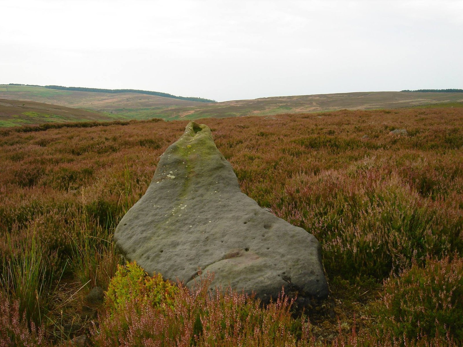
At SE48090 98917 this Neolithic Pointer lay’s close to a Bronze Age Field System. I have explored this area several times and find that much more time is needed as it is a vast area called Near Moor and was due in pre-history connected to Scratch Wood Moor to the north west. The pointer itself has a tapered cup mark it lay’s in deep heather but don’t show much of erosion. And indeed it points N-W at summer solstice sunset just where the tree line end at far horizon. In Neolithic times it would a been 1 degree to the right on your compass and today it sits 2 degree’s to your left on your compass reading due to earth rotation.

It can be accessed  in several ways or though there is no direct footpath to it , in June 2014 i took the sheep wash – red way route over the top this is the longer way. In July i went over sheep wash- pamperdale ridge which seems shorter  and either way you will come across some boggy area with small beck crossing not to bad due summer month’s I’ll say comes autumn and winter this bog will be deep.

11802790_423184751216515_2676591247286996369_o


Yorkshire’s “Sacred Vale” – The Dawn of Brigantia

The “Sacred” Vale of Mowbray – Brigantia’s Neolithic Capital?

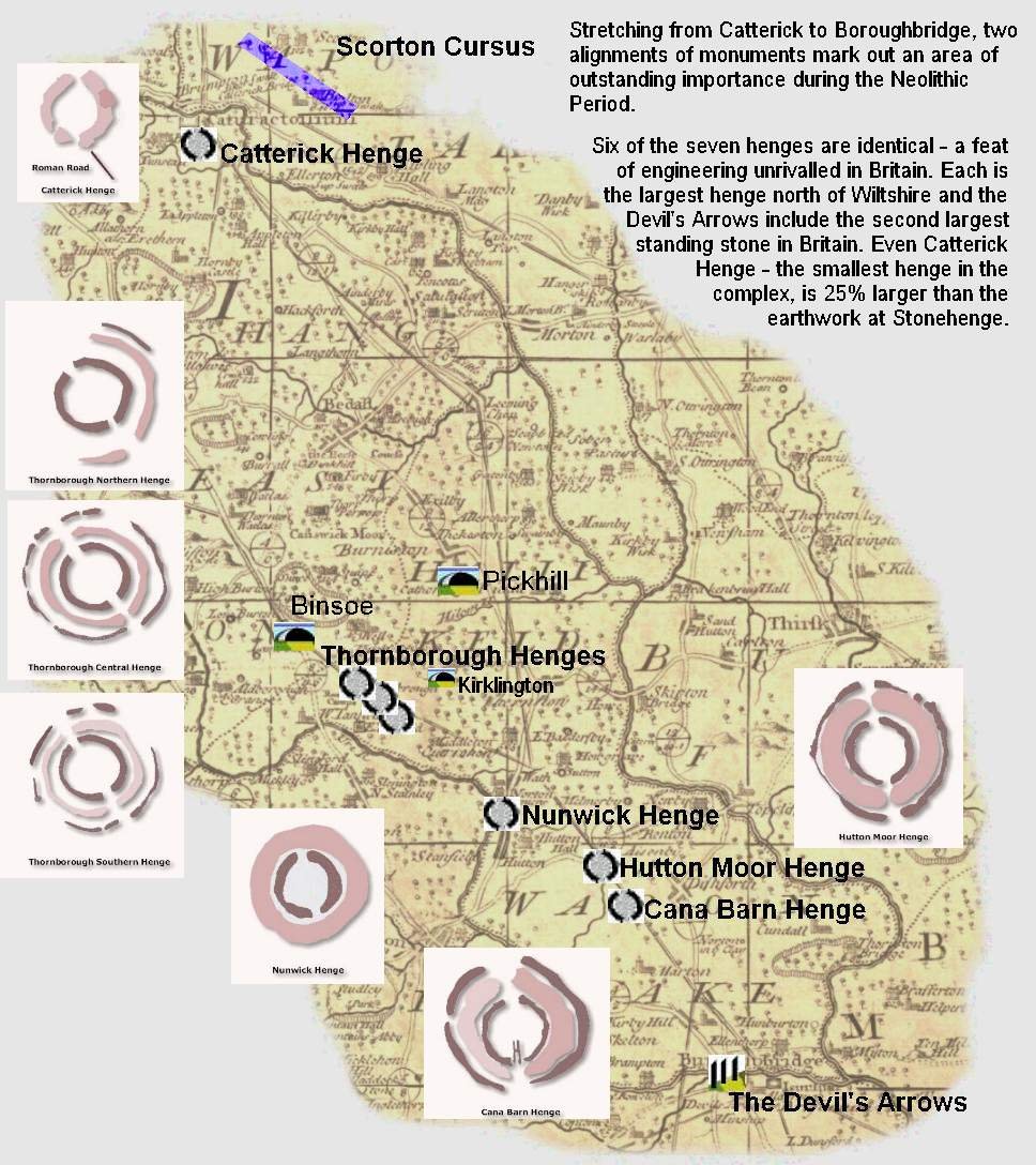
More than 2,000 years before the discovery and widespread use of Iron an unprecedented bout of monument building in the centre of Brigantia created the Britain’s largest religious monument complex, a place that has been suggested as being Britain’s religious capital during the Neolithic Period.

Whatever it was, these monuments were amongst the largest in Britain and will have been an important part of Brigantia’s cultural heritage.

The first monuments erected within the Vale of Mowbray were the cursus monuments. The largest cursus in the north of England was Scorton Cursus, this was over 2.1km long and is now mostly destroyed by quarrying. The other cursus,Thornborough Central Cursus was smaller at approx. 1.2km and is now mostly destroyed by quarrying.

These are seen as the first communal ritual monuments ands clearly mark out an area that is interpreted as being “ceremonial ways” – places for processions. Cursuses often are associated with a number of funery monuments, as can be seen at Scorton – a number of barrows cluster round it. At Thornborough the cursus is close by a Neolithic mortuary enclosure – a place for the laying out of the dead prior to burial. The cursus monuments, though these have yet to be dated, are believed to date from around 3,500 BC.

These cursus monuments created within the area two sacred spaces that in many ways define the area of the “Sacred Vale” – each is associated with a river – Thornborough/Ure and Scorton/Swale – these two rivers join at Boroughbridge to create a clearly defined region that in later years was to become a very significant place.

Around 3,000 BC, the Sacred Vale was created. The critical locations of Thornborough, Boroughbridge and Scorton (via Catterick) were linked with two great alignments of henges. In all, at least six henges were built – The three at Thornborough, Catterick Hutton Moor, Nunwick and Cana Barn. Catterick was the smallest henge in the Vale at 100m in diameter yet this is still one of Britain’s largest henges. The three henges at Thornborough and those at Hutton and Cana were possibly as large as 300m in diameter originally and had an outer bank and inner segmented ditch that created multiple entrances, this created the largest concentration of henges in Britain and was the largest building project attempted during the Neolithic as far as we can tell.

Thornborough Henges Devil's Arrows Catterick Henge Scorton Cursus Hutton Moor Henge Pickhill Artificial Mound Kirklington Barrow


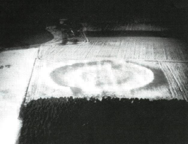
Hutton Moor Henge, North Yorkshire


Hutton Moor Henge, North Yorkshire.

Hutton Moor Henge, Photo by Ray Selkirk


The Kingdom of Venutius

The Kingdom of Venutius – Brigantia – AD 69

“Inspired by these differences between the Roman forces and by the many rumours of civil was that reached them, the britons plucked up courage under the leadership of Venutius, who, in addition to his own natural spirit and hatred of the Roman name, was fired by his personal resentment towards queen Cartimandua. She was ruler over the Brigantes, having the influence that belongs to high birth, and she had later strengthened her power when she was credited weith having captured king Caratacus by treachery and so furnished an adornment for the triumph of Claudius Caesar. From this came her wealth and the wanton spirit which success breeds. She grew to despise her husband Venutius, and took as her consort his squire Vellocatus, whom she admitted to share the throne with her. Her house was at once shaken by this scandalous act. Her husband was favoured by the sentiments of all the citzens; the adulterer was supported by the queens pashion for him and by her savage spirit. So Venutius, calling in aid from outside and at the same time assisted by a revolt of the Brigantes themselves, put Cartimanua into an extremely dangerous position. Then she asked the Romans for protection, and some of our auxiliary troops, cavalry and infantry, after meeting with indifferent success in a number of engagements, finally succeeded in snatching the queen from danger. The throne was left to Venutius, the war to us.” Tacitus (Histories iii, 45).

Tacitus, Roman historian of the 1st Century AD. has provided us with most of the written history of the Brigantes at the time of the Roman conquest. The above text, written about a time when Nero had fallen and Rome endured several emporers in one year – AD69 clearly illustrates the date when Venutius finally became king of all Brigantia.

The few references thast we have from Tacitus and other Roman authors provide a dim glimpse of the events that surrounded the Roman conquest of Brigantia, yet the story is a tantalising one, a tail of royal adultery, power struggles, revolution and conquest. Brigantesnation.com began life as an experiment to see if it was possible to recreate more accurately this lost history of Brigantia, to see if recent developments in archaeology could help fill the gaps left by those ancient authors.

Firstly, we need to understand the gaps – Source Documents

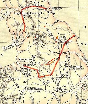
This map outlines a postulated border for the Brigantia of Venutius in AD69. By this time Venutius had ousted Cartimandua from her throne and was King of Brigantia. A small area to the south shows the territory already lost to Roman rule.

In order to verify this border, this research attempts to locate the defences that Venutius set up in anticipation of the Roman advance.

The map has click zones which identify major military sites available to Venutius, although many have date yet to be proven, most can be demonstrated to be pre-Roman, and therefore available for use.

The southern border, shown in red, complies with the Roman frontier, as implied by fort locations and other dating evidence.

Devil's Arrows Standing Stones  Roman border area AD69 Boltby Scar Hill Fort Roman Rig - Venutius' southeastern border Ingleborough Hill Fort Tor Dyke - Defense Mam Tor Cartimandua's territory Brigantes border with the Parisi Carl Walk Hill Fort Devil's Arrows Standing Stones Stanwick Hill Fort Boltby Scar Hill Fort Rouslton Scar Hill Fort Cleave Dyke Defence System

Cleave Dyke Defensive System, North Yorkshire

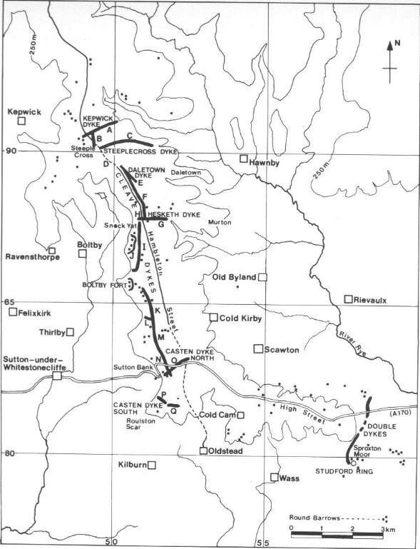
Cleave Dyke System

The Cleave dyke system is several Dykes which combine to create a boundary of between 9 and 18 kilometres running north south to the west of Thirsk. To date excavations have found minimal dating evidence, but a pre roman date has been given which means if not built by Venutius the Dyke system was certainly available for use by Venutius. The Dyke itself is in close very close proximity to the hill forts of Boltby and Roulston Scar. Other dykes has been reported to the north and south of this system and it is therefore likely to have been used to define the border and to create a defensive possition against possible Roman (or Parisian) attack.

Interestingly this defence is some distance from the later Parisi – Brigantes border (other side of York) and may indicate (1) That the Parisii occupied a larger area prior to the Roman conquest, (2) Venutius moved the border to a more defensable position, or (3) the apparent “defending the barrows” position was deliberate, aimed a providing a defensive wall for the earlier Bronze age barrows. Or a combination of the three.

Boltby Hill Fort Roulston Scar Hill Fort

Cleave Dyke overview

Tor Dyke, North Yorkshire

Tor Dyke – North Yorkshire

Preliminary Report
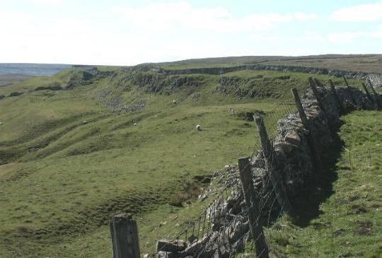
Tor Dyke can be seen traced by the full length of the wall seen in the picture, it extends the natural escarpment of Cam Head which can be seen to the far left. This view is from the eastern side looking west.

Introduction

“Around AD70 the rebel Brigantian Chief Venutius built the ditch of Tor Dyke close to Great Whernside as part of a defence system against Roman invasion. Despite a hold on other areas, (including Ingleborough and Gregory Scar north of Grassington), Venutius and his forces were overcome by the Romans.” This reference was taken from one of Mike Harding’s walking guides. A site visit to Gregory Scar has been performed, and although it has been dubbed “Fort Gregory” by the Dales Park Authority it does not appear to be much more than a small, very unusual settlement.

Tor Dyke appears to have been attributed to Venutius which dates it of the period AD 52 – 70. The presence of a legionary size marching camp a few miles to the southwest at Malham certainly indicates an active role in the Roman advance of AD 70. However, given the lack of published research so far a clear picture has yet to emerge.

Summary

The above multimap air photo shows the much scale of Tor Dyke, it streatches almost the entire width of the photo. To the right, almost at the end of the visible works is the entrance shown in photo’s below.

Tor Dyke is a large escarpment type hill fort a 2Km stretch of man – enhanced fortification links with natural escarpment to create a 3+Km defensive rampart.

Location

Tor Dyke is close to Kettlewell in the Yorkshire Dales. OS Landranger 98 1:50,000 ref. 986756

Getting there

The narrow road from Kettlewell to West Witton cuts right through Tor Dyke about 4 Km north of Kettlewell. Immediately after cutting through the dyke the grass verge by a cairn is good for parking. A clear footpath travels the whole length of the fortification. For the best effect, a climb up Great Whernside is not as hard as it looks. The site is always muddy and boggy, although the footpath in the main is free from serious boggy bits.

Warning – Shake holes

The area is strewn with shake holes, which are the remains of mining from later periods. In some cases these are very deep, have steep sides (usually conical) and are filled with water.

On the east side the main entrance is to be found. Way in from the south is to the left of the picture.
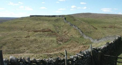
Another view of the entrance, to show possible aditional ditch heading south.

This view shows the eastern side of the defences, they follow the wall almost to the point where it takes a sharp left turn to head up Great Whernside. This is an obvious weak spot and it is possible that it had additional defensive works.
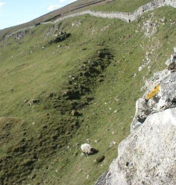
Following the rampart towards the western side, in places outer defencive ditches can still be seen to an approximate depth of 2m. This indicates a possible original depth of 6m. Width estimated at 6m.

Further Research

1. Small enclosure located attached to rampart, needs to be investigated and mapped if in period.

2. Diagram of the fortification required.

3. More accurate sizing information for the rampart is required.

4. Excavations happening by Archaeologist Dr. Roger Martlew (University of Leeds) is planning an extensive project to explore the entire area – watching brief.

5. If this dyke defined a frontier, then other defences will have been required in parallel valleys to provide the required level of enclosure. Dykes of this sort will have been used to regulate frontier traffic with minimum manpower commitment.

References

Still looking

The Gallus Frontier – Brigantia against the Romans

The Gallus Frontier – Roman Rig and associated Iron Age Forts

Brough-on-Noe Leicester Lincoln Owmby Hibaldstow Old Winteringham High Cross Mancetter Willoughby-on-the-Wolds Margidunum Thorpe-by-Newark Brough Owston on the Trent Doncaster Chester Camp Farm Whitchurch Wall Pennocrucium Flint Scraptoft Crossing of the Poulter Templeborough Littlechester Chesterfield Mid-point Rocester/Brough-on-Noe Rochester Trent Vale Northwich Wilderspool Mid-point Wall/Littlechester Mid-point Northwich/Brough-on-Noe Broxtowe Marton Pentrich Almondbury Hill Fort Barwick in Elmet Hill Fort Osmathorpe Newton-on-Trent Rossington Bridge Roman Rig Carl Wark hill fort Wincobank hill fort Scholes Coppice Camp


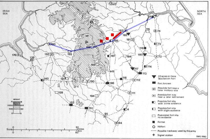
The Gallus frontier, outlined in blue, south of the line, the Roman fortifications, to the north, Venutius’ kingdom.

The Frontier changes made by Gallus

In “Rome against Caratacus” Graham Webster put forward the proposal that Gallus was forced to remodel the existing Plautian northern frontier on the Humber-Trent line in order to protect Roman interest in the unstable Brigantia. He did this Webster suggested, by moving forward a network of forts towards and into the southern border of Brigantia. It should be noted that specific dating evidence is not available for all forts, and Websters proposal, and our interpretation are based on as much deduction as knowledge.

The above illustration shows the possible northern Roman frontier attributed to Gallus c.57 A.D. At Sheffield, along a significant stretch of this possible frontier, within a couple of miles of the front line forts there is a defensive dyke and possible fort system which has been suggested by some archaeologists as representing the Southern border for an anti Roman section of the Brigantes at in the first century AD. In short, Roman Rig may well have been Venutus’ defence against the Romans in preparation for the Roman invasion C69-71AD.

This research article aims to collate any related research so that a clear body of evidence can either prove or disprove this theory. Currently, there are a small number of positive findings with regards to Roman Rig and the associated Brigantian forts, as well as the Roman counterparts, some evidence is relatively new and still being investigated. However the lack of negative evidence gives a good indication that this key element to the Brigantian jigsaw – Venutius’ south eastern border 69AD.

To investigate the evidence currently to had click on the site indicators that are clickable, this will lead to individual site reports.

The Dyke is built to defend against the south and runs from Sheffield, past Templeborough and carries on almost to Doncaster. If this is an Brigantian dyke it would certainly add weight Websters definition of the border.

By accepting that this dyke may be a Brigantian counterpart to the defences set up in the period of Gallus’ governorship, we may examine the implications of the dyke as belonging to Ventutius or Cartimandua, and thus we can place a possible border for one of the two adversaries at a particular time..

One conclusion could be that the dyke belonged to Cartimandua, built as part of her defences against Venutius. If this were the case then this would date the age of the Dyke to c. 69AD when Venutius is believed to have overthrown Cartimandua and taken control of Brigantia.

The other conclusion is that the dyke belonged to Venutius, in the same period, but built against the Romans as part of his defences after he ousted Cartimandua.

Contact Us
close slider

    What is 8 + 3?