Stonehenge has always been enigmatic, due to its use of those definitive morticed trilithons, all of which where squared of, Read more
Cumbria
Cumbria’s dramatic landscapes are the product of a 500-million-year geological saga, punctuated by mountain-building, volcanic upheaval, Limestone burial, tectonic extension and, finally, repeated ice-age sculpting. Today it can be divided into four broad physiographic regions.
The Lake District Massif
At the heart of Cumbria lies the Lake District—a roughly oval block of Ordovician and Silurian rocks intruded by Devonian granites. The oldest sediments (Skiddaw Group mudstones and siltstones) form the northern fells, while the central core—the Borrowdale Volcanic Group—consists of hard lavas and ash flows that give rise to the highest peaks (Scafell Pike, Helvellyn). Underneath, a suite of granitic intrusions (Eskdale, Ennerdale, Shap granites) once fed surface volcanoes; those plutons now underlie much of the central plateau. Later Silurian slates and sandstones cap the lower flanks on the south and east margins (en.wikipedia.org, englishlakedistrictgeology.org.uk).
The Carboniferous Margins and Pennine Front
Surrounding the volcanic core to the north, east and south is a horseshoe of Carboniferous sedimentary rocks: thick limestones of the Carboniferous Limestone Supergroup, followed upsection by Millstone Grit sandstones and Coal Measures Shales. These form the gentle hill country of the Vale of Eden and the high moorland plateaux of the North Pennines. The eastern edge of this belt is defined by the steep Scarp of the Askrigg Block, giving rise to ridges like Cross Fell. This limestone-sandstone succession underpins fertile pastures, upland grass moors and the great Dales river valleys (cumberland-geol-soc.org.uk, geolsoc.org.uk).
The Vale of Eden and Border Lowlands
The Vale of Eden itself is a narrow, fault-bounded half-graben that separates the Lake District from the Pennines. Here Permo-Triassic sandstones and breccias (Appleby Group, local “Brockram”) overlie eroded Carboniferous beds, producing a gently rolling flood-plain through which the River Eden flows northward toward the Solway Firth. To the west and south lie low-lying Drumlin fields and coastal plains of West Cumbria and Furness, where glacial till and post-glacial sediments cap older rocks (geolsoc.org.uk, pubs.geoscienceworld.org).
Quaternary Glaciation and Modern Topography
From about 2.6 million to 11,700 years ago, repeated Pleistocene glaciations carved Cumbria’s present form. Thick ice sheets flowed out from the Lake District and Pennines, scouring U-shaped valleys, over-deepening basins (now occupied by Windermere, Ullswater and Derwentwater) and depositing Moraines that dammed tributary valleys. On the coastal fringe, glacio-fluvial gravels and raised beaches record ice margins and post-glacial sea-level changes. The result is the iconic contrast of craggy fells, ribbon lakes and tiered valley sides that defines Cumbria today (en.wikipedia.org, cumberland-geol-soc.org.uk).
Human Interaction with the Landscape
Humans have been reshaping Cumbria’s landscape for at least 12,000 years, leaving a rich mixture of sites that track changing economies, beliefs and social structures.
Mesolithic Foragers and the First Occupation
The earliest evidence comes from Late Upper Palaeolithic and Mesolithic hunter-gatherers exploiting coastal and riverine resources. At Maryport on the Solway Plain, excavations uncovered worked flint and tuff tools dating to the Final Palaeolithic Federmesser groups, around 11,000 BC (intarch.ac.uk). Similar microlith assemblages in cave deposits at Netherhall Road, Allithwaite, show Mesolithic foragers seasonally visiting limestone outcrops to hunt red deer and gather hazelnuts, leaving charcoal peaks in peat profiles as silent testimony to their campfires (intarch.ac.uk).
Neolithic Farmers and Monument Builders
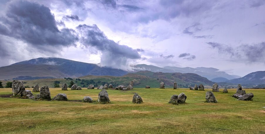
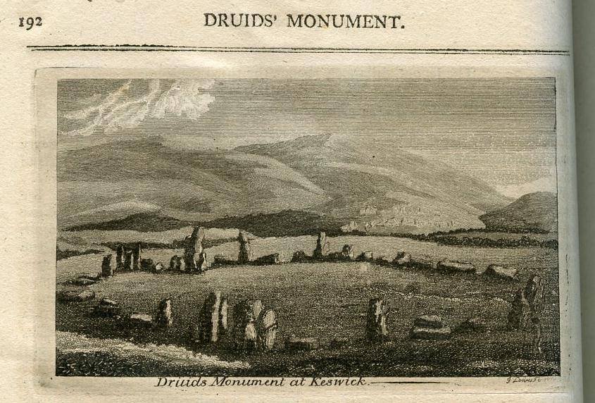
From around 4000 BC, Neolithic farmers began clearing forest for grazing and cultivating small cereal plots. They also erected some of Britain’s most evocative megaliths: the Langdale axe “factory” at Pike o’ Stickle supplied polished greenstone axes traded as far away as Norfolk and Northern Ireland, while the Castlerigg Stone Circle (c. 3000 BC) crowns a natural amphitheatre beneath Skiddaw, its 38 erratic boulders aligned to sunrise views (english-heritage.org.uk). On the low limestone plateau near Penrith stand the massive Mayburgh Henge and King Arthur’s Round Table, Earthwork circles that defined communal ritual spaces amid the budding pastoral economy (en.wikipedia.org).
Bronze and Iron Age Communities
By 2500 BC, metallurgy arrived via Bell-Beaker networks, and small Cairn cemeteries—like Kirkhaugh on the South Tyne—commemorated specialist metal-workers interred with gold hair-braids and copper tools . Iron-Age farmsteads and hill-forts—such as Maiden Castle near Pooley Bridge—then dotted the fells, their univallate ramparts and hut platforms integrating upland grazing with strategic oversight of valleys below .
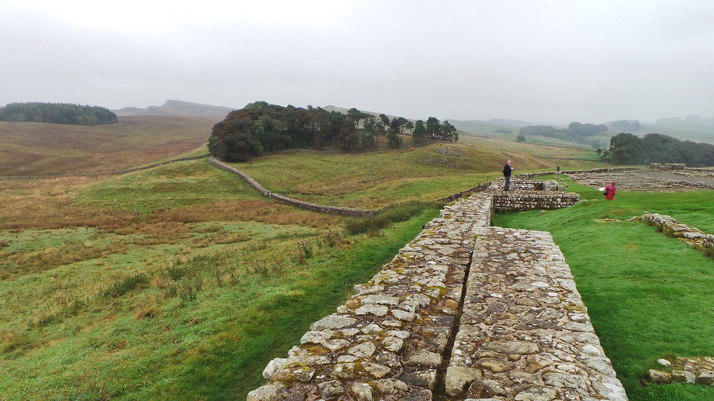
From AD 122, Cumbria lay on Rome’s north-western frontier. Hadrian’s Wall stretches 117 km from Bowness-on-Solway to Wallsend, with forts at Birdoswald, Chesters and Housesteads guarding the wild moorland (geographical.co.uk). Along the Solway coast, mile forts and a Roman cremation cemetery at Mile fort 15 attest to a mixed military and civilian presence trading local metals and fish for Samian ware and bronze brooches (en.wikipedia.org).
Medieval to Modern Transformations
After Rome’s retreat, Cumbria evolved through Anglian and Norse settlement, leaving place-names and enclosure patterns in the Eden and Derwent valleys. Castles—most prominently Carlisle and Brougham—anchor medieval lordship and border conflicts.
From the 17th century, the same veins that had drawn Bronze-Age smiths fuelled a booming lead and zinc industry in Alston Moor and Nenthead, leaving spoil-heaps and ruined Engine-houses that, alongside railways and quarries, transformed the landscape.
A silver threepence of Elizabeth I (1558 to 1603), second coinage and dated to 157(8?), with plain cross initial mark. London Tower mint. As North vol2, (1991) No. 1998. [...]
A silver medieval halfgroat of Henry VII (1485-1509), martlet initial mark dating to 1501-1509. Archiepiscopal mint of Archbishop Savage at York. As North 1714. [...]
A Iron Age silver "concave square" minim of the Regini and Atrebates / Southern region, possibly attributable to Tincomarus and dating to 50-20 BC. Obverse: square with concave sides, central pellet in ring. Reverse: annulet horse [...]
A post Medieval cast copper alloy discoidal 1/4oz trade weight. The weight has a upstanding rim enclosing a recessed upper surface bearing stamps of a crowned W for William III (1694-1702). [...]
A post-Medieval silver threepence of Elizabeth I (1558-1603). Second issue (1561-1582), probably portcullis initial mark and dated 1566 on the coin. London Tower mint. As North (1991) no. 1998. [...]
A complete silver Scottish twelve shillings coin of James VI of Scotland and I of England, eighth coinage post-dating accession to English throne, dating to 1603-1625, Lys initial mark. Reverse has a shield with arms of [...]
A silver Post-Medieval shilling of Elizabeth I, third issue with ‘A’ initial mark dating to 1583-1585. Mint of London. As North Vol 2, p.136, no.2014. [...]
A lead alloy pipe tamper dating to the 17th century. The plate has moulded decoration to both sides depicting Charles I (facing right) and Henrietta Maria of France (facing left). Both images are contained in [...]
A damaged lead-alloy Medieval pilgrim's ampulla, 50mm in length and 35mm wide, with a round bodied flask with a flaring open top which is partially complete. One side of the flask body has traces of moulded [...]
An incomplete Medieval cast copper alloy buckle plate, dating to c. AD 1100-1400. The plate is missing its buckle and part of its sprues. The buckle plate is sub-rectangular in plan. Projecting from one long edge [...]
A Roman copper-alloy nummus of the House of Valentinian , dating to AD 364-7 (Reece Period 19), GLORIA RO-MANORVM reverse type depicting the emperor with right hand dragging captive right and holding a labarum in left hand. Mint of [...]
A Post-Medieval copper alloy farthing of Charles I (AD 1625-1649), dating to AD 1636-1644. Rose type 2, with sceptres in saltire through single crown. Mint of London. Unclear initial mark. North (1991: 165) no. 2291. [...]
A clipped and heavily worn Roman copper alloy nummus of Gratian (AD 367-383) dating to the period AD 367-378 (Reece period 19). SECURITAS REI PUBLICAE reverse type depicting Victory advancing left, holding a wreath and palm. Unknown mint. [...]
A silver Roman siliqua of Honorius (AD 393-423) dating to the period AD 397-402 (Reece Period 21) minted in Milan VIRTVS ROMANORVM reverse type depicting Roma seated left on cuirass, holding Victory on globe and spear. Hoxne, p. 145, no. [...]
An incomplete Roman composite plate brooch probably dating to AD 100-200. The brooch is missing it's pin and part of the top and bottom circles. The brooch is flat in cross section and probably originally consisted of [...]
Fragment from a probable buckle frame dating to the Post Medieval period (c.AD 1720-1790). The fragment is broadly rectangular in plan and includes a short section of the corner of the buckle frame. The fragment includes the [...]
Fragment from a buckle frame dating to the Post Medieval period (c.AD 1720-1790). The fragment is broadly C shaped in plan and D shaped in profile. It consists of two corners and one side of a sub-rectangular [...]
A complete copper alloy bovine (bull's head) vessel / bucket mount, dating to the Roman period (c. AD 50-200).The cast copper alloy mount is a sub-inverted triangle with a pointed lower tip and slightly waisted sides to form the nose.The [...]


")


