Notice: Function WP_Scripts::add was called incorrectly. The script with the handle "datatables-responsive" was enqueued with dependencies that are not registered: datatables. Please see Debugging in WordPress for more information. (This message was added in version 6.9.1.) in /home/u621095157/domains/brigantesnation.com/public_html/wp-includes/functions.php on line 6131
This article explores the most tangible evidence we possess for indigenous minting north of the Humber: the smashed ceramic “pellet-mould” Read more
Location
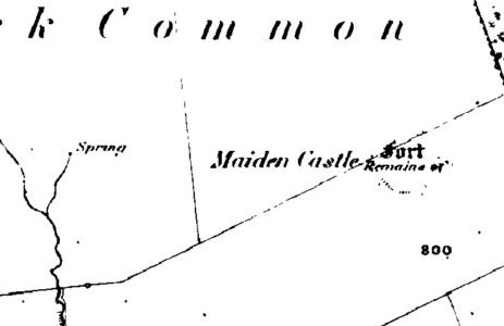
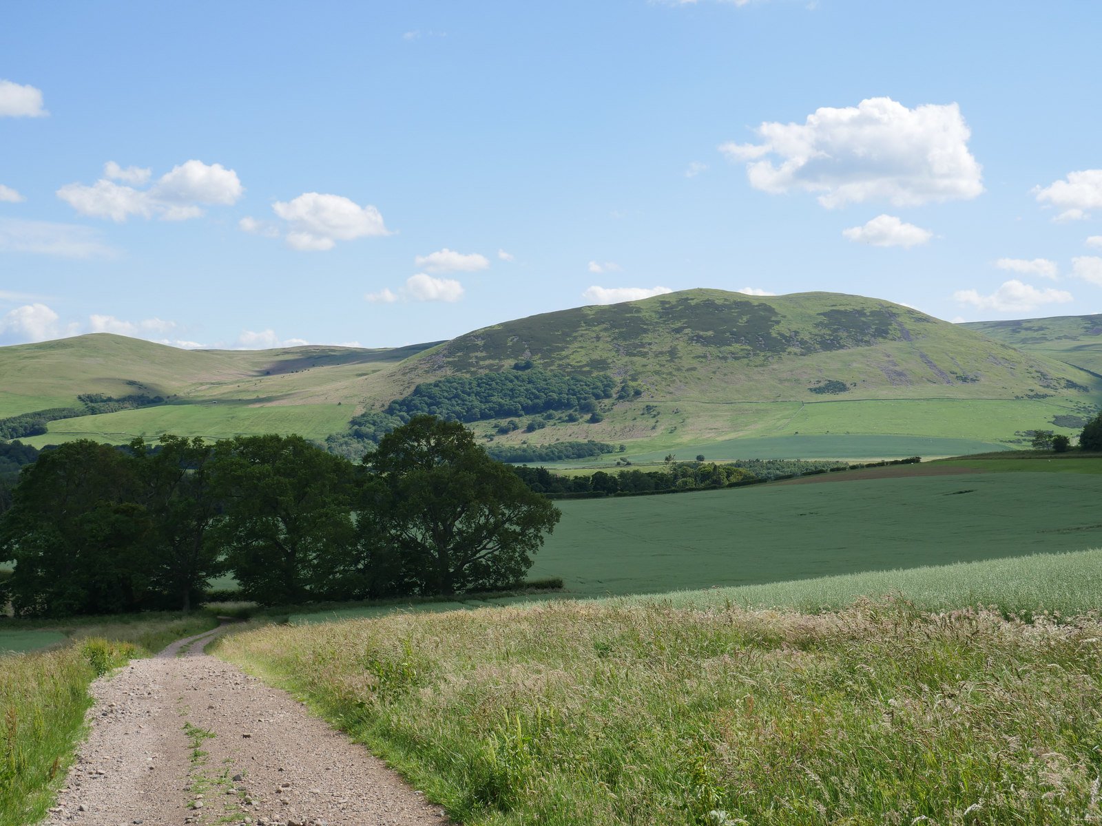
Maiden Castle sits on the southern slopes overlooking Ullswater, roughly one mile west of Pooley Bridge at National Grid reference NY 451243 (latitude 54.61086 N, longitude 2.85153 W). Perched at about 200 m above sea level, the enclosure occupies a gentle convex spur that commands panoramic views across the Eden Valley to the Pennine fells beyond (megalithic.co.uk).
A superbly circular "fort", built on the side of the hill, which seems to be a Brigantian fashion (see below). This is built with two rampart walls and a very narrow ditch between - 1-2m. If these were defences, they seem pretty slight. In it's way, a miniature version of Wandlebury, but only about 200m circumference.
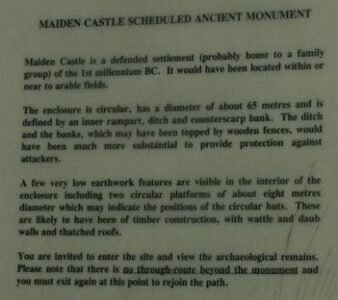
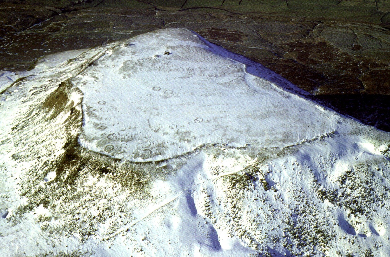
The monument itself is a near-perfect circle some 65 m in diameter. It is defined by an inner earth-and-stone rampart—about 5 m wide and standing up to 1 m high—encircled by a flat-bottomed ditch roughly 5 m across and 0.5 m deep. Beyond the ditch lies a low counterscarp bank some 5 m wide (megalithic.co.uk). Inside the enclosure two sub-circular platforms, each about 8 m across, mark the positions of hut sites, while adjacent sunken hollows may have served as livestock paddocks (ullswaterheritage.org).
Brigantian Farmstead?
Typologically and by its construction, Maiden Castle could be best understood as an Iron-Age farmstead—part of the Brigantian cultural horizon that stretched across northern England in the 1st millennium BC. Its small size, simple univallate defence and excellent views suggest a mixed domestic and protective function rather than a purely military one (themodernantiquarian.com).
Excavations
No large-scale excavations have been undertaken here, but field surveys, aerial photography and Earthwork recording—summarised in the Pastscape record—confirm its prehistoric date and detailed form. Limited test-pitting in the 1980s noted charcoal-rich fills in the ditch, hinting at domestic burning, but otherwise the site remains largely undisturbed beneath turf and heather (megalithic.co.uk).
Post-Iron Age
In the post-Roman and medieval eras Maiden Castle fell out of use and was progressively reclaimed by pasture. In the 20th century it became a Scheduled Ancient Monument, managed informally by local landowners and walkers on the Ullswater Way. Today it stands as a well-preserved fragment of the Iron-Age landscape, a testimony to the small-scale farmsteads that dotted Cumbria’s hillsides and helped knit together the social and economic fabric of pre-Roman Britain (ullswaterheritage.org).
Henge Fort?
The very slight ramparts, with no outer ditch, together with the circular shape of the monument give this "fort" a definite henge feel.
Although Maiden Castle is usually classed as a defended settlement (probably home to a family group) of the 1st millennium BC). Recent debate regarding the precise nature of such enclosures has been under debate, and the dating of Henges, such of Castle Dykes in North Yorkshire, to Iron Age, mean our narrow view of defended enclosures and hillforts is under review.
Local Environment
It would probably have been located within or near to arable fields. The ditch's and the banks, which may have been topped by wooden fences, would have been much more substantial to provide protection against attackers.
A few very low earthwork features are visible in the interior of the enclosure including two circular platforms of about eight meters diameter which may indicate the positions of circular huts, These are likely to have been of timber construction, with wattle and daub walls and thatched roofs." From a sign by the earthwork.
The location of Maiden Castle could not have been strictly for its defensive position, as can be seen from the photo, its position made it vulnerable on one side and also meant the occupants had limited views of the surrounding area. If anything it hides amongst the hills.
Poor Defensive Positioning
This poor defensive positioning is an aspect shared by several other Brigantian earthworks of presumed defensive capacity, including Maiden Castle (Reeth), Stanwick (North Yorkshire), Scholes Coppice (South ( South Yorkshire), Castle Steads (North Yorkshire) and quite a few others. This has caused a fair degree of confusion in defining what their purpose actually was. There seem to be several schools of thought on the subject, each may be correct for particular earthworks. These vary from seeing these as tactical camps not intended to be held in difficult circumstances, to being seen more as symbolic or even religious in purpose.

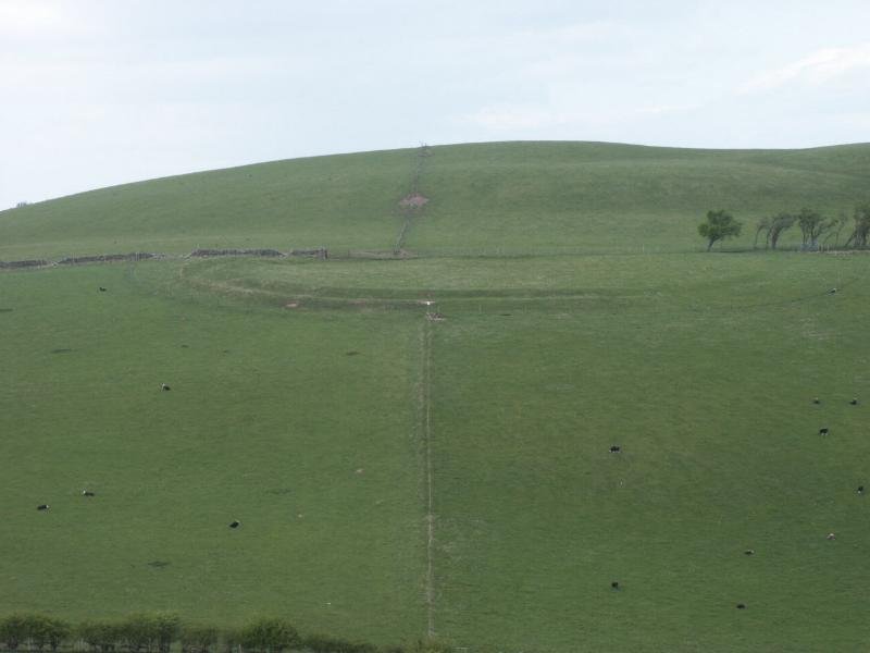


 A superbly circular "fort", built on the side of the hill, which seems to be a Brigantian fashion (see below). This is built with two rampart walls and a very narrow ditch between - 1-2m. If these were defences, they seem pretty slight. In it's way, a miniature version of Wandlebury, but only about 200m circumference.
 In the post-Roman and medieval eras Maiden Castle fell out of use and was progressively reclaimed by pasture. In the 20th century it became a Scheduled Ancient Monument, managed informally by local landowners and walkers on the Ullswater Way. Today it stands as a well-preserved fragment of the Iron-Age landscape, a testimony to the small-scale farmsteads that dotted Cumbria’s hillsides and helped knit together the social and economic fabric of pre-Roman Britain (ullswaterheritage.org).