Location: North Yorkshire

Earthworks at Stainton

The earthworks surrounding Stainton in North Yorkshire are part of a rich archaeological tapestry that speaks to the region’s ancient past. These structures are believed to be remnants of extensive field systems, possibly dating back to the post-Roman period.

Ellerton Abbey

Ellerton Abbey, nestled in the picturesque landscape of North Yorkshire, holds a rich tapestry of history that intertwines with the broader narratives of England’s past.

Marrick Priory

Marrick Priory, a historic gem nestled in the Yorkshire Dales, has a rich history that dates back to the 12th century.

Penhill Preceptory – Chapel of the Knights Templar

The history of Penhill Preceptory is closely tied to the dramatic rise and fall of the Knights Templar. The order was initially founded to protect Christian pilgrims travelling to the Holy Land, but over time, they amassed great wealth and influence, which eventually led to their downfall.

Grinton Lodge Earthworks

The earthworks that sit on the hillside between Grinton Lodge and the B6270 are part of a fascinating archaeological landscape in North Yorkshire. These features are distinct from the nearby Grinton-Fremington Dyke System, which dates back to the post-Roman period and is believed to have formed part of the boundary of an early British kingdom.

Field Systems at Reeth

The field systems at Reeth are particularly noted for their historical coaxial layout, and are characterized by long, parallel boundaries that run across the landscape, a pattern indicative of significant central organization and planning.

Newton Kyme Henge

With kind permission of YAAMAPPING

Newton Kyme Henge occupies a slight rise on the south bank of the River Wharfe immediately west of the village of Newton Kyme (OS grid SE 45945 44982), its maximum external diameter extending to around 250 m (heritagegateway.org.uk). The monument is best understood as a Class IIa henge of Late Neolithic–Early Bronze Age date, defined by three concentric ditch circuits with a turf-and-earth bank wedged between the inner and middle ditches.

Bainbridge Roman Fort

With kind permission of YAAMAPPING

Particularly of note is the multiple defense ditches to the west, the extension of the entire fort to the east and the well defined entranceway to the south (other entrances are available)But the real stunner is the 2 interior shots: firstly the interior of the classic fort itself where we have a road coming in from the south entrance and going north, surrounded by at least 5 buildings, all with wall lines clearly defined.

Bainbridge Camp – Hill Fort

With kind permission of YAAMAPPING

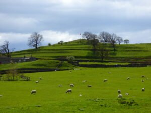
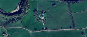
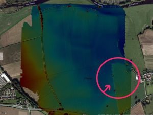
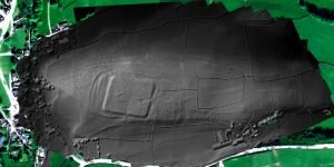
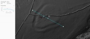
The subject of much speculation and, frankly, little fact this looks like a classic hill fort to us, check out the below elevation map of the area with the hillfort showing up beautifully. We have also included elevation profiles so you, dear readers, can appreciate the classic hill top location: note how from all directions the hillfort perches nicely on the top of the highest point: visible from all directions and can see in all directions. A classic see & be seen location, achieving the twin aims of defence and impressing visitors.

Sinderby Henge

With kind permission of YAAMAPPING

Although all the existing literature assures us that the Great Henge Alignments of North Yorkshire are now covered by – The Langthorpe Earthwork, Cana Barn Henge, Nunwick Henge and Hutton Moor, finishing with the astounding triple Henge alignment at Thornborough, this may not necessarily be the case.

Contact Us
close slider