"We were shocked to discover such a huge complex," said Alastair Oswald, archaeological field investigator for English Heritage. Preliminary examinations Read more
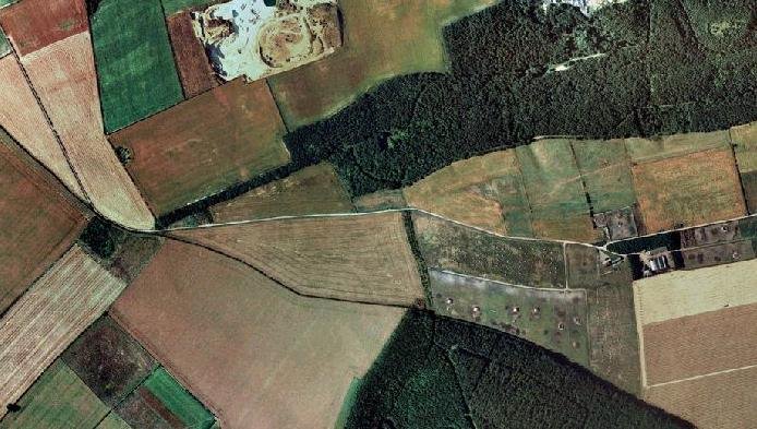
"Whorlton, Live Moor, (NZ 496012) A previously unrecorded Promontory fort was identified by D. Smith on air photographs and later Read more
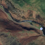
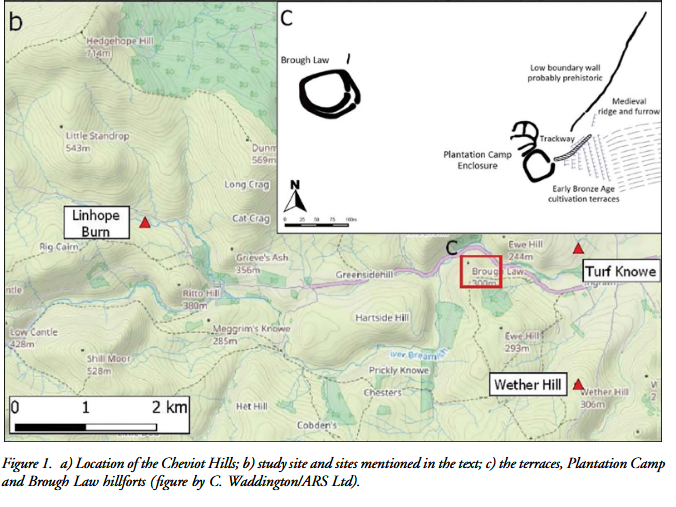
Brough Law Bronze Age Terraces
Summary and supplemental information in relation to the publication: Early‐Middle Bronze-Age Agricultural Terraces in North-East England: Morphology, Dating & Cultural Implications. Download below:
Context & aims of the report
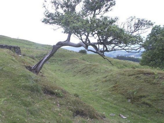
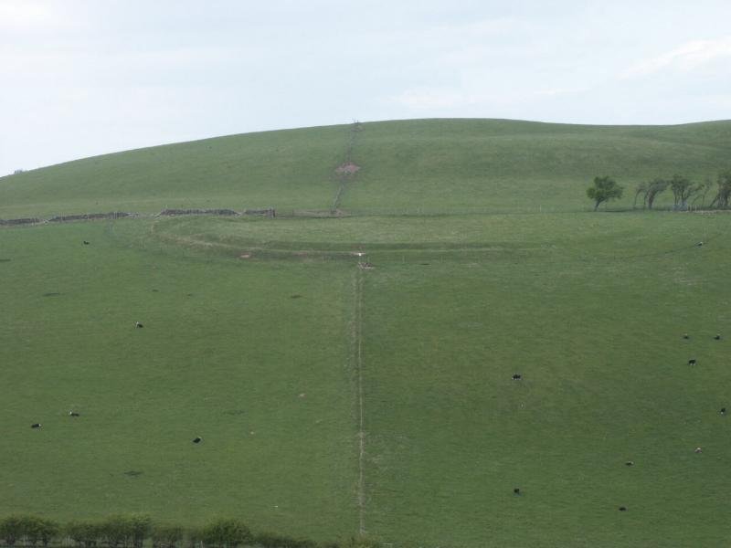
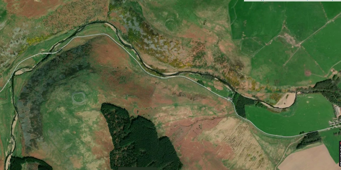
A multidisciplinary team re-examined a staircase of seven cultivation terraces on Ewe Hill, Breamish Valley (Cheviot Hills, Northumberland). Using high-resolution UAV Photogrammetry, geoarchaeology, portable OSL profiling, phytolith/pollen analysis and a new suite of radiocarbon assays (standard AMS + HyPy on pyrogenic carbon), the authors sought to pin down when the terraces were built and farmed, and how they fit into wider Bronze-Age land-use change.
Key findings on dating the terracing
Evidence line
Result
Chronological significance
Pre-terrace buried soils under T1 wall – two AMS/HyPy dates
5190 ± 70 BP (4011–3801 cal BC) and 5815 ± 25 BP (4777–4553 cal BC)
Terminus-ante-quem: terrace construction must be after Late Mesolithic/Early Neolithic soils were sealed.
Direct evidence for construction episode(s) in the Early Bronze Age.
Buried Ap/B horizons on tread surfaces
Portable-OSL profiles show single “slow-accumulation” units immediately above construction horizon
Supports Early Bronze-Age build followed by gradual soil accretion rather than multiple later rebuilds.
Barley grain from pit cut into T3 tread
1820 ± 40 BP (AD 168–338)
Provides a latest-use marker (terraces pre-date but were still present/visible by Romano-British period).
Modelled chronology
Terrace staircase built c. 1890–1520 cal BC (95 % confidence) – probably 1860–1620 cal BC (68 % confidence).
Soil‐build-up and cultivation continued into the Middle Bronze Age (≤ c. 1400 cal BC).
By the time a trackway to the adjacent Roman Iron-Age enclosure was laid and a Romano-British pit dug, the terraces were already ancient earthworks, implying abandonment before the 2nd century AD.
Implications
Earliest securely dated cut-and-fill terraces in Britain – pushes intensive slope-modification for arable into the Early Bronze Age, aligning with wider evidence for a mid-second-millennium BC agricultural “take-off”.
Labour investment indicates either population pressure or elite-organised intensification in the Cheviots at that time.
Terraces were used for cereal cultivation (pollen & phytoliths show barley/wheat) in an already open landscape; stone revetments were augmented as ploughing mobilised colluvium.
Their abandonment may relate to later Bronze-Age climatic downturns, soil fatigue or social re-organisation, parallelling the cessation of high-altitude cultivation elsewhere (e.g. Dartmoor Reaves).
Construction of the Breamish terraces is firmly anchored to Early-to-Middle Bronze Age (∼ 1800–1500 BC) farming, making them a rare, well-dated example of prehistoric land-engineering in northern Britain and an important marker of Bronze-Age demographic and cultural change.
Other pre-Roman examples of landscape Terracing in England
Below are some of the best-documented examples of prehistoric (pre-Roman) agricultural or cultivation terraces in Britain, together with the dating evidence that links them to Bronze- or Iron-Age activity. They show that the Early–Middle Bronze-Age complex in the Breamish Valley is not an isolated case, although it remains the earliest securely dated cut-and-fill system so far.
Region / site
Form of terracing
Dating evidence & range
Notes
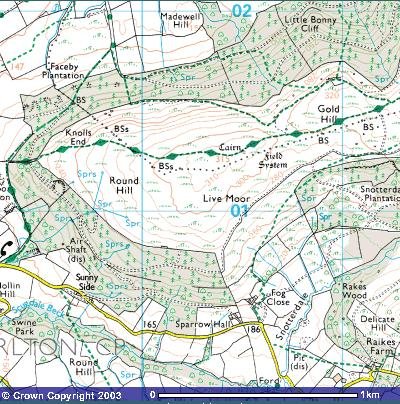
Ewe Hill, Breamish Valley, Northumberland
Seven stone-revetted cultivation terraces
Radiocarbon & HyPy on buried soils and basal fills: c. 1860–1620 BC (build); cultivation to ≤ 1400 BC
Cheviot & Border Uplands (e.g. Hut Knowe, Snear Hill, Greenlee Lough)
Broad lynchet-like terraces and narrow cord-rig ridged strips on slopes
Cord-rig runs beneath Hadrian’s Wall (post-AD 122), proving a late Iron-Age or earlier date; South Shields excavation gave 3rd–4th century BC dates for rig under the Roman fort (Oxford Reference, ResearchGate)
Cord-rig often merges with larger lynchets; extensive systems mapped by LiDAR across the Cheviots (Research Frameworks)
Plumpton Plain field system, South Downs, East Sussex
Field investigation and Beaker/Late-Bronze-Age pottery suggest c. 2500–900 BC for initial laying-out; Historic England survey summarises evidence (Historic England, The Times)
One of the best-preserved chalk-downland lynchet complexes; comparable to nearby Itford Hill
Itford Hill & “Itford-Hill–style” settlements, South Downs
Terraced enclosures & lynchet fields on spurs
Classic excavation (Burstow & Holleyman 1957) placed construction in the Late Bronze Age (c. 1000–800 BC); remains cited in recent South-East research agenda (Wikipedia, Kent County Council)
Typologically similar complexes occur along the Sussex Downs (e.g. Black Patch)
Dartmoor Reaves (Devon)
Extensive coaxial field systems; lynchet scarps form on steeper slopes
Stone reave walls date to the Middle–Late Bronze Age (c. 1700–1200 BC); lynchet formation subsequent to ploughing against reaves (Fleming 1988)(Wikipedia)
Terracing is incidental to wall-building but creates clear tread/risers on many valley sides
Terraced track & fields, Chalton Down, Hampshire
Low lynchets flanking a terraced droveway
Associated pottery & enclosure features indicate a Middle–Late Bronze-Age date (Academia)
Berkshire Downs lynchets (Lambourn area)
Massive chalk lynchets
Early excavators suggested c. 1000 BC, but 1990 re-assessment favoured Romano-British origins for many; highlights dating difficulties and need for direct assays (Penn Museum)
What the corpus shows
Terracing is widespread but unevenly dated. Long-known lynchet systems on chalk and Limestone (South Downs, Berkshire Downs, Wessex) were traditionally ascribed to “Celtic” Iron-Age farmers; only targeted excavation or new techniques (e.g. HyPy radiocarbon, OSL) can separate true prehistoric examples from later Medieval or Roman cultivation scarps.
Techniques vary with geology and society.
Stone-reverted cut-and-fill terraces (Breamish) required heavy labour investment—hinting at communal or elite-directed projects early in the 2nd millennium BC.
Cord-rig and simple lynchets in the Border Uplands and Dartmoor show lighter engineering but equally early adoption, often linked to upland spade-cultivation or clearance for cereal plots.
Many prehistoric terraces continued to be visible (and sometimes reused) into the Roman or Medieval period, explaining why later artefacts sometimes sit in terrace–tread soils while the construction horizon remains Bronze-Age.
Dating still relies on opportunistic exposures. Secure chronologies come where terrace risers seal buried soils, or where structures (Hadrian’s Wall, hillfort ditches) provide stratigraphic brackets. Systematic coring, OSL profiling and Bayesian radiocarbon modelling—as used at Ewe Hill—are beginning to refine the timeline.
Beyond the newly dated Cheviot example, a cluster of terraced field systems and cord-rig complexes across southern England, the Cheviots/Borders and Dartmoor can confidently be assigned to Bronze- or Iron-Age cultivation. The picture is still patchy, but accumulating evidence shows that large-scale slope modification for agriculture was part of Britain’s prehistoric landscape centuries before Roman influence arrived.
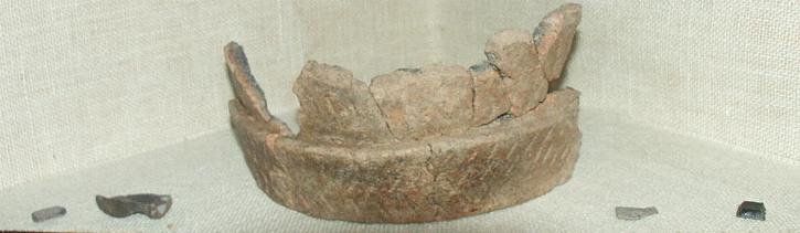
A Probable Neolithic flint piece of debitage possbily intended to be a blade.The fragment is made from a tertiary flake of semi-glossy light grey flint with slightly darker grey patches. It is sub-triangular in plan [...]
A very worn and chipped Roman copper alloy radiate of uncertain emperor dating to the period AD 260-275 (Reece period 13). Unclear reverse type depicting figure standing left. Unclear mint. [...]
A heavily worn Medieval silver 'short cross' cut farthing of an uncertain monarch, Henry II to Henry III dating to the period c.1180-1247. Not further defined.Length: 9.6mm; width: 9.4mm; thickness: 0.5mm; weight: 0.4g. [...]
Silver medieval penny of an uncertain ruler, probably Henry V to Henry VI (1413 - 1461) minted at York. The coin is in poor condition, is 16mm in diameter and weighs 1.00g. [...]
A Roman copper-alloy radiate of Tetricus I/II dating to circa AD 271-274 (Reece Period 13). PAX AVG reverse type depicting Pax standing left holding branch and vertical sceptre. Gallic Mint I. [...]
A Roman copper-alloy nummus of Magnentius or Decentius dating to AD 250-253 (Reece Period 18). VICTORIAE DD NN AVG ET CAE reverse type depicting two Victories holding wreath inscribed [VOT/V/MVLT/X]. Mint of Trier. [...]
A Roman silver denarius of Antoninus Pius (AD 138-161) dating to AD 154-155 (Reece Period 7). COS [IIII] reverse type depicting Fortuna, draped, standing right, holding rudder, vertical on globe, in right hand and cornucopiae, with tip [...]
A Roman copper-alloy barbarous radiate copying a coin of Victorinus (AD 268-270) dating to circa AD 275-285 (Reece Period 14). Copying PAX AVG reverse type depicting Pax standing left holding branch and transverse sceptre. Unclear [...]
A Roman copper-alloy radiate of Carausius (AD 286-293) dating to circa AD 286-293 (Reece Period 14). PAX AVG reverse type depicting Pax standing holding branch and vertical sceptre. Unclear mint. [...]
A Roman copper alloy radiate of Tetricus II (AD 272-274) dating to circa AD 272-274 (Reece Period 1). [SPES AVG] reverse type depicting Spes walking left holding branch and raising hem of robe. Unclear mint. [...]
A free-standing pierced stone weight of uncertain age, but probably dating to the Post Medieval period.The object is sub-square in plan and rectangular in cross section. Its sides appear to have been sanded to give [...]
A Roman copper-alloy barbarous radiate copying a coin of Divus Claudius II (AD 270-271) dating to circa AD 275-285 (Reece Period 14). Copying CONSECRATIO reverse type depicting altar with crescent. Unclear prototype mint. [...]
A free-standing cast lead conical 12.43g weight of uncertain age, but probably dating to the Post Medieval period.It has a sub-circular base with concave tapering sides up to a slightly flattened apex. A circular hole runs through [...]
A free-standing cast lead conical 20.79g weight of uncertain age, but probably dating to the Post Medieval period.It has a sub-circular base with tapering sides up to a slightly flattened apex. A circular hole runs through the [...]
A clipped Post Medieval silver halfgroat of James I (AD 1603-1625). First coinage, dating to AD 1603-1604. Mint of London. North (1991: 144) No. 2076, thistle mintmark. [...]
A very worn Post Medieval silver three pence of Elizabeth I (AD 1558-1603) second coinage dating to AD 1561-1582. Mint of London. Unclear initial mark. North (1991: 135) no. 1998. [...]


 Brough Law Bronze Age Terraces
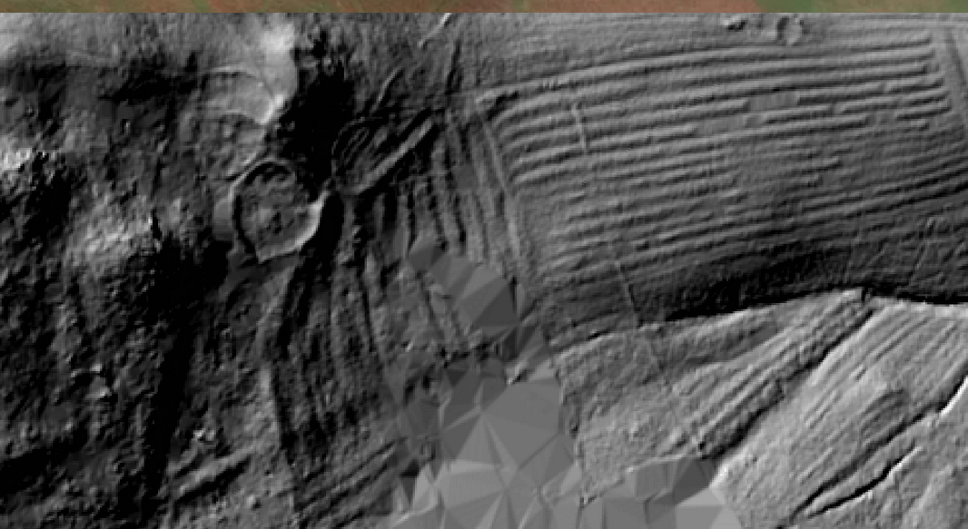

 Modelled chronology
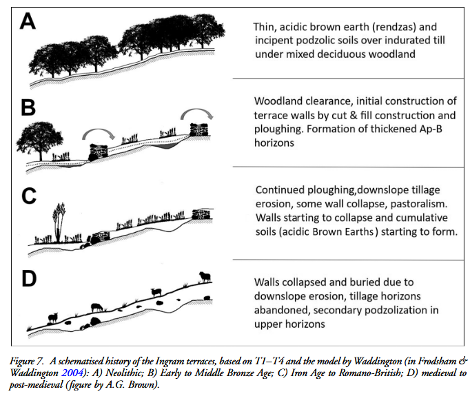 Implications