Notice: Function WP_Scripts::add was called incorrectly. The script with the handle "datatables-responsive" was enqueued with dependencies that are not registered: datatables. Please see Debugging in WordPress for more information. (This message was added in version 6.9.1.) in /home/u621095157/domains/brigantesnation.com/public_html/wp-includes/functions.php on line 6131
East Yorkshire’s Middle-Iron-Age story stands out in Britain because the communities who farmed the chalk of the Yorkshire Wolds developed Read more
West Scrafton, Coverdale
West Scrafton is a village located in Coverdale in the Yorkshire Dales. It sits on the southern upward slops of Coverdale, and had its most recent heyday in the 19th century when coal mining took over the village.
Name & early origins
Scrafton is first recorded in the Domesday survey of 1086 as Scræftun (three carucates under Ghilepatric), its Old-English elements scræf + tūn meaning “settlement at the hollow/cave” – an apt description of the little green tucked below the heather moor tops. By 1286 the estate had split into East and West Scrafton, the western vill occupying the sunny south bank of the River Cover. (Wikipedia)
A monastic landscape (13th – 16th c.)
After the Norman Conquest the township became part of the grange network of Coverham Abbey. A surviving fragment is The Chantry: a 15-century chantry-chapel (now a cottage) with a Perpendicular two-light window that once housed canons serving the abbey’s sheep-and-grain estate. It is today Grade II listed. (Historic England) Another medieval survivor is Bow Bridge – the narrow, barrel-arched Pack-horse bridge over Great Gill. Its core masonry is probably 16th-century; modern widening hides the original arch but the bridge retains Grade II status. (NYD Walks) High on the slope behind the village, you can still pick out broad lynchet terraces – scarps created by repeated ploughing in the late-medieval open fields and mentioned in walking guides as a “distinctive medieval feature”. (NYD Walks)
Coal on the moor (19th – early 20th c.)
While lead and coal defined neighbouring dales, West Scrafton worked a thin coal seam on the moor. West Scrafton Colliery operated intermittently between the 1870s and 1914, its deepest Shaft dropping 110 m to seams barely 18 inches thick. Output—mainly domestic fuel for dale farms—never exceeded a few tons a week, yet the mine left spoil tips and capped shafts that still dot the skyline. (Northern Mine Research Society)
Non-conformist chapels & rural life (19th c.)
Methodism thrived where Coverdale folk faced a long trek to the parish church. West Scrafton built two chapels in 1866—Primitive Methodist and Wesleyan. The Wesleyan closed in 1930 (later a Scouts’ hostel and now a holiday cottage); the Primitive Methodist chapel held its last service in 2014 after 148 years. (Genuki, Wikimedia Commons)
Listed vernacular architecture
With barely forty dwellings, a third of the village is Grade II listed. Besides The Chantry and Bow Bridge, examples include Crag View, a late-18th-century rubble-stone farmhouse overlooking the green, and several field barns with characteristic Dales bee-boles and laithe-house plans. (Historic England)
Twentieth-century fame
The dale’s timeless scenery drew vet-author James Herriot, who holidayed here with his wife; West Scrafton then appeared in the TV adaptations All Creatures Great & Small (“A New Chapter”, “Alarms & Excursions”) bringing the hamlet brief national exposure. (Wikipedia)
Folklore – the “Coverdale Ghost Light”
Local legend tells of an eerie head-lamp–bright glow that drifts along the narrow lane between East Scrafton and Caldbergh most autumn nights—a phenomenon widely reported in the 1930s press interviews with butcher J. Pickersgill and others (one West Scrafton man “has seen it more than anybody”). Folk connect the light with the murder of a young woman whose shade in black lace supposedly paces the road. (Stump Cross Caverns)
What the place tells us
West Scrafton compresses a millennium of Yorkshire-Dales history into one tiny settlement:
Pre medieval roots, visible in the name and terraced fields;
Monastic agrarian capitalism, preserved in The Chantry and pack-horse infrastructure;
A brief industrial blip on the coal-rich moor;
Religious pluralism played out in paired chapels; and
Living folklore—ghost-lights, TV myth-making and the quiet resilience of a dale community of c. 70 souls.
Walk the bridleway up Great Bank and you look back over green pasture, strip-lynchers and stone roofs—a layered Palimpsest where each lump of masonry or odd local tale whispers another chapter of Coverdale’s long story.
Archaeology of West Scrafton
Period
Site / find
What it is & why it matters
Key evidence for date/function
Later Prehistory
Cairn on Great Roova Crags (upper moor, SE 0882 8208)
Small stone cairn on the skyline above the village – one of several that crown the Haw/Roova ridge. Interpreted as a Bronze-Age burial or way-marker that once overlooked the Cover valley route.
Intact circular mound visible on aerial and ground photographs; typical Bronze-Age upland cairn morphology. (Geograph)
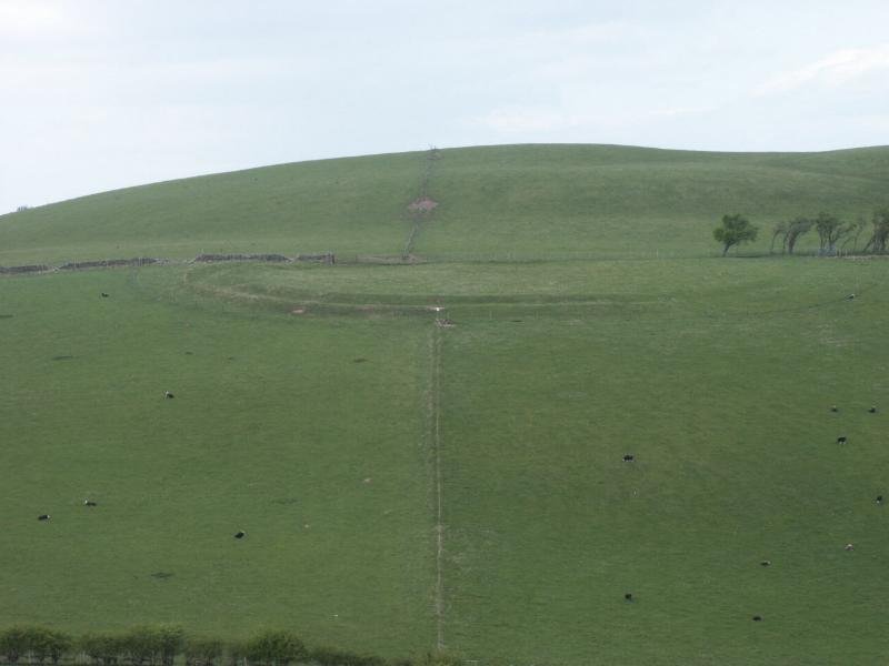
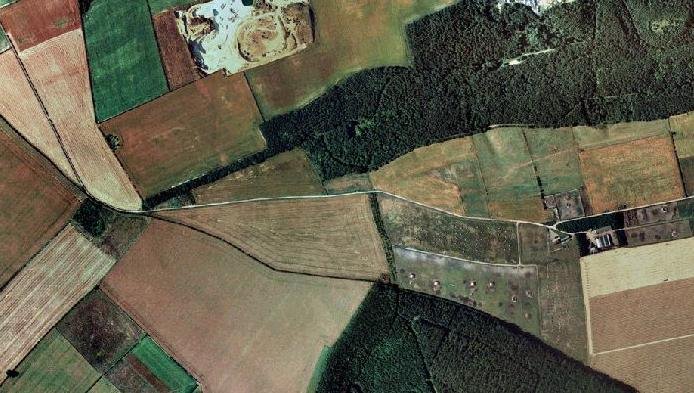
Platform / enclosure Earthworks NE of West Scrafton
Low rectilinear banks, scoops and platforms seen on vertical and oblique air-photos. Could be a shrunken farmstead or stock-corral, predating the medieval open fields.
Cambridge University air-photo series BEV31-35 show the complex in plan. No excavation yet. (cambridgeairphotos.com)
Early-/High-Medieval cultivation
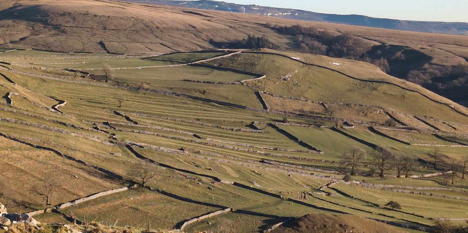
Strip-lynchet terraces on the north-facing slope below the village
Parallel “step” scarps formed by centuries of ox-ploughing – the best-preserved medieval open-field lynchets in Coverdale. Still dominate the pasture visible from the green.
Period photographs and recent walk-guides describe them as “Anglo-Saxon or medieval” arable strips. (Leeds Digital Library, NYD Walks)
Later Medieval monastic landscape
The Chantry (15th-c. Chapel / grange office) & associated Coach-house
Surviving piece of Coverham Abbey’s grange at West Scrafton; Perpendicular east window still in-situ.
Shallow coalfield on West Scrafton Moor – shaft mounds, gin‐circles, tramway scoops.
2015 earthwork survey and ADS grey-literature report document every shaft and spoil-tip. (Archaeology Data Service)
Natural subterranean archaeology
West Scrafton Pot
600 m-long Limestone cave draining the beck under the village; explored by cavers since the 1960s. Notable for Carboniferous marine fossils (Gigantoproductus) and speleothem development.
Speleological journals & visitor accounts; local heritage site notes the underground course to the Cover at “Otter’s Hole”. (Visitor UK, wessex-cave-club.org)
What these remains tell us
Continuity of land-use – from Bronze-Age Cairns through medieval open-field farming to Victorian coal-working, the same hillside has been re-purposed for 3,500 years.
Monastic imprint – the Chantry and Bow Bridge anchor West Scrafton within Coverham Abbey’s 13th–16th-century sheep-and-grain economy.
Rare upland cultivation evidence – the lynchet system is among the clearest in the Yorkshire Dales, illustrating how medieval communities wrested arable ground from steep slopes.
Industrial “after-life” – shaft mounds and spoil on the moor record a short-lived but well-documented episode of dale-side coal extraction.
Sub-surface heritage – West Scrafton Pot reminds us that archaeological potential is not only at ground level; caves can archive palaeoenvironmental data and local folklore alike.
Together these sites create a compact, multi-layered archaeological landscape encircling the village – one that rewards both desk-based research and a field-walk from the green up to the moor‐top crags.


 West Scrafton, Coverdale
 Name & early origins
 A monastic landscape (13th – 16th c.)
 High on the slope behind the village, you can still pick out broad lynchet terraces – scarps created by repeated ploughing in the late-medieval open fields and mentioned in walking guides as a “distinctive medieval feature”. (NYD Walks)


")


