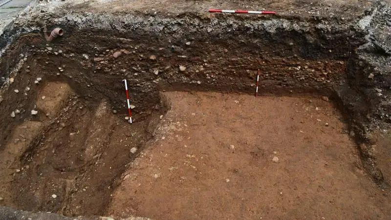
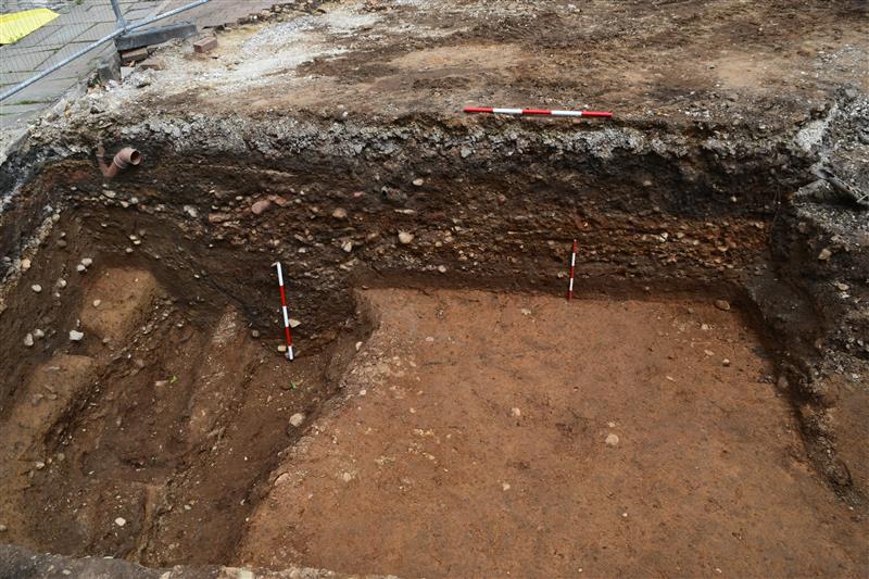
Section of Roman road in an excavation trench, Manchester, England – CIVIC
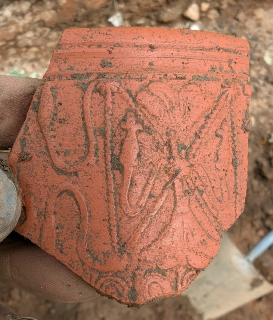
Fragment of decorated Samian ware recovered during excavations – CIVIC
MANCHESTER, ENGLAND—According to a BBC report, archaeologists were surprised to find a Roman road just beneath the surface of Manchester’s city centre. It is remarkable that the 2,000-year-old road is so well-preserved, given that it lies only 15 inches beneath the busy modern Liverpool Street in the city’s Castlefield section.
The site is near to the Roman fort of Mamucium, which was established around a.d. 78 and from which the modern city takes its name. Experts believe it may have been the main northern exit route away from the Roman settlement.
The team uncovered a number of Romano-British artifacts dating to between the first and third century a.d., including pottery and glassware, that provided a timeframe for the road’s use. “It’s certainly the best Roman archaeology I’ve seen in the city centre for 20 years and probably more than that,” said Ian Miller from the Greater Manchester Archaeological Advisory Service.
What was found?
A stretch of Roman road 380-400 cm (150 in) below Liverpool Road in Castlefield. The trench shows the classic Roman construction sequence – a cambered rubble core surfaced with tightly packed cobbles – and runs on a north-east/south-west alignment that leaves Mamucium’s north gate and heads towards modern Salford. Civic
Dating evidence. Associated pottery ranges from fine Samian-ware to coarse utilitarian jars, plus decorated glass and butchered animal bone, giving a use-span from the late 1st to mid-3rd centuries A.D.
Industrial hearths and slag. These lie a few metres off the carriageway and point to small-scale metal-working in the civilian vicus that wrapped round the fort.
Why is it important?
Significance
Context
Best-preserved Roman feature in the city for 20+ years.
Most Roman layers in Manchester sit 1–3 m down, truncated by Victorian cellars; here, post-industrial terracing protected the road almost at present ground level.
“Missing link” in the fort’s road grid.
Earlier digs (1970s–90s) sampled the eastern and southern approach roads; the newly exposed stretch is the first tangible evidence for Mamucium’s northern exit – the line that ultimately joins the Ribchester (Bremetennacum) road and, beyond it, the route to Hadrian’s Wall. Wikipedia, All That’s Interesting
Helps knit together two earlier excavation blocks.
Ian Miller (GMAAS) notes that it physically connects the 1980s Castlefield Heritage Park digs with 1990s interventions north of Liverpool Road, allowing a continuous plan of the vicus for the first time. Civic
How Roman roads were built – and why this one survived
Agger – a raised embankment of clay, gravel and demolition rubble (here c. 0.4 m).
Metalling – fist-sized Gritstone cobbles tightly wedged; the surface is still cambered to shed water.
Side-ditches – not yet fully exposed, but geophysics suggests a 6–6.5 m overall carriageway.
Later burial – when the fort was abandoned (late 3rd c.) the road gradually silted, then disappeared under medieval cultivation and finally under 19th-century railway spoil. That shallow overburden explains its remarkable Preservation. Construction Management
Fitting it into the wider Roman network
Mamucium (founded c. A.D. 79) sat at a strategic crossroads:
East-west legionary highway Eboracum (York) ↔ Deva (Chester), running just south of the fort.
North-south road Ribchester → Carlisle. The new Castlefield stretch is almost certainly the first hundred metres of this route.
From Ribchester the line joins Margary 7c towards Burrow and on to Hadrian’s Wall, explaining why Manchester’s garrison never exceeded cohort size: the fort’s main job was traffic control, not frontier defence. Penelope
Where the newly‑exposed Liverpool Street stretch leads
W / WSW (branches a little south of the new trench)
Coccium (Wigan)
c. 17 mi
onward to the Chester‑to‑York trunk road near Wilderspool/Deva
S → SW (separate exit gate aligned on modern Chester Rd)
Condate (Northwich) then Deva Victrix (Chester)
18 mi / 37 mi
legionary supply route from Wales and the Irish Sea
The Liverpool Street alignment is therefore the primary northern outlet from Mamucium, feeding traffic to Ribchester and—beyond it—the chain of forts that marches up the Lune valley to the western sector of the Wall.
Intermediate way‑stations and possible fortlets on the Ribchester road
Archaeological and LiDAR work (Roman Roads Research Association; GMAU) has logged several suspected small forts or signal stations that punctuate the 7b line:
Rainsough Hill (Bury): Earthwork noted by antiquarians; pottery scatter suggests late‑1st/2nd‑c. use. (Heritage Gateway, Landscape Britain)
Affetside/Top o’ th’ Moor (edge of modern Bolton): agger and agger‑flank quarries visible; a 2021 drone survey hints at a rectangular platform just west of the road that could represent a fortlet gate tower stance. (romanroads.org)
Radcliffe: 1950s trench recorded cambered road metalling and massive timber post‑holes—possibly a temporary bridgehead or causeway stabiliser at the Irwell meander. (eprints.oxfordarchaeology.com)
None has yet yielded datable structural timber, but all strengthen the view that Mamucium‑Ribchester was a fully militarised supply corridor.
Has the Roman bridge (or ford) out of Manchester been found?
Irwell crossing – not yet located.
Excavations and service trenches around Salford Bridge/Cathedral area have produced stray Roman finds but no masonry abutments or piles that can be tied to a Roman phase. (salford-repository.worktribe.com, Project Gutenberg)
Historians since the 19th c. have therefore favoured a stone‑block ford at Cornbrook, 600 m downstream, mentioned in several environmental histories of the Irwell. (naturalcourse.co.uk, Wikipedia)
Industrial‑era levelling removed many earlier riverbank deposits, so a timber‑pile bridge (à la London’s 1st‑c. Thames crossings) could have been destroyed without trace.
Medlock crossing – part of the same exit route but inside the vicus; rescue digs on Chester Road in 2003 exposed revetted ramps and water‑logged log‑facing thought to stabilise a minor bridge or culvert, yet again no intact superstructure. (salford-repository.worktribe.com)
We know the road angles directly toward both rivers, but physical bridge remains remain unconfirmed; all current evidence supports a permanent engineered ford over the Irwell and a shorter bridge or culvert over the Medlock just below the fort.
Fixing the exact crossing will lock down the width of the military zone north of Mamucium and test Margary’s straight‑line reconstruction of 7b.
If a stone bridge is eventually found it would imply a long‑term, high‑traffic investment comparable to Chester’s Dee bridge or Piercebridge on the Tees; a ford suggests lighter, yet still strategic, usage.
Discovery of abutments could yield dendrochronology or mortar chemistry to tie the structure precisely to one of the fort’s three main building phases.
Summary
Liverpool Street’s Roman layer is part of Margary 7b report, the supply road to Ribchester and, by extension, the Lune valley and Hadrian’s Wall. Along that 26 mi stretch lie at least three probable fortlets or signal stations that kept the line secure.
Despite two centuries of digging we still lack a diagnosed Roman bridge over the Irwell; current thinking favours a robust stone‑block ford at Cornbrook, with any timber bridge now lost to later river engineering.
This discovery plugs a crucial gap in Manchester’s Roman jigsaw: it confirms the line of the fort’s northern artery, preserves a textbook example of Roman engineering just beneath a modern pavement, and offers a snapshot of civilian life—industrial hearths, imported tableware and butchered bone—on the very edge of empire.
An incomplete cast copper alloy double looped trapezoidal buckle of post medieval date. Only one loop remains. The frame is narrow with bevelled edges and a narrowed strap bar. There is no visible decoration. [...]
An incomplete cast copper alloy Roman bow brooch, of plate headed hinged T-shaped type dating to the 2nd century AD. The arms are narrow and cylindrical, enclosing an axis spindle and with a notch at the centre [...]
A worn and corroded post-Medieval copper-alloy Nuremberg Jetton of anonymous 'ship-penny' type (c. 1490-1550). Obverse has a sailing ship, the reverse has four fleur-de-lis in a lozenge. Illiterate legends. Cf. Mitchiner 1152-1165. [...]
Lead token, tally or boardgame piece. Hammered bifacial disc with one side bearing a pattern or device resembling a stylised tree with stocky fringed trunk and an arcing ‘legend’ of dots between faintly defined circles. [...]
Silver coin fragment. Worn long cross round halfpenny, broken to achieve well under one farthing’s weight, issue of 1280-1327Obverse description: worn smoothReverse description: long cross, three pellets in each angleReverse inscription: CIVI/[TAS]/(----)Diameter: 14.3mm, Weight: 0.23gms [...]
Silver coin. Short cross cut halfpenny of John (1199-1216) or Henry III (1216-1272), London mint. Class 6a1 issue of 1208-1218Obverse description: facing bust with sceptre left, hair left of two oval curls, beard of fine [...]
Copper alloy unidentified object fragment. Cast square-section bar with a stepped and rounded end; other end broken. The rounded tip forbids interpretation as a nail shank, which this object otherwise resembles. Suggested date: possibly Roman, [...]
Copper alloy finger ring. Cast oval bezel and tapered/constricting shoulders of a finger ring; the bezel is filled with blue enamel, sunken in the middle and crazed by recent impact; Guiraud type 1. The rest [...]
Silver coin. Penny of Edward I (1272-1307), class 10cf3 issue of 1307-1309, London mintObverse description: facing bust with broad bifoliate crown cf3 with break in band, drapery of angled wedges, initial cross pattee.Obverse inscription: +EDW [...]
A Medieval silver groat of Edward III (AD 1327-1377). Series E (North 1163) dating to AD 1354-5. London mint. North (1991: 51). Edge on the lower right quarter on the obverse has broken away. Coin measures 28.3mm in diameter. [...]
Silver coin. Voided long cross cut halfpenny of Henry III (1216-1272), probably class 3a issue of 1248-1250Obverse description: facing bust no sceptre, legend starts at 12 O’clock, hair comprises two neat curls and pellets left [...]
Copper alloy brooch fragment. A now-cruciform scrap of a cast plate brooch, possibly Mackreth type British Plate [unspecified], comprising the paired U-shaped lugs from the seat for a hinged pin, with a flat front retaining [...]
Silver coin. Denarius of an indeterminate early Roman emperor, cut with the loss of about one fifth of the flan, probably issue of AD14-138.Obverse description: bust laureate draped right, clean-shaven and jowled, lightly tousled hair.Obverse [...]
A worn and corroded Roman copper alloy nummus of the House of Constantine dating to AD 330-340 (Reece period 17). VRBS ROMA type with a reverse depicting Romulus and Remus suckling a wolf, with three stars above. Mint of Trier. Cf. LRBC Vol [...]
Lead and iron possible steelyard weight, as kindly suggested by the finder. An irregular plano-convex lump of cast lead retaining relicts of a heavy iron suspension loop with recent breakage evident; the lead is slightly [...]
A Roman copper alloy nummus of Constantine II (AD 317 - 340) dating to AD 327 (Reece period 16). PROVIDENTIAE CAESS reverse depicting a camp-gate of two towers with a star above. Mint of Arelatum / Arles. [...]
A post medieval, lead human figurine probably dating from the late 18th- 19th century.The figurine is in the form of a standing figure, possibly female holding a baby. Possibly depicting Mary with child. The reverse is flat [...]
A medieval cast copper alloy single looped oval buckle, complete with plate and pin. The frame has a rounded front edge and a recessed strap bar with lobes at either end. The plate is sub triangular [...]