Location: England

Scorton Cursus

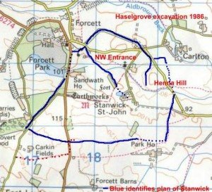
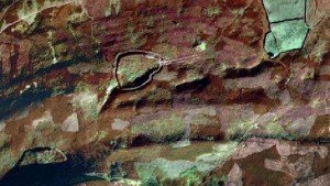
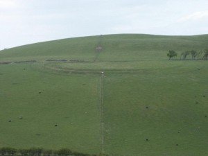
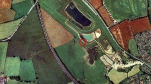
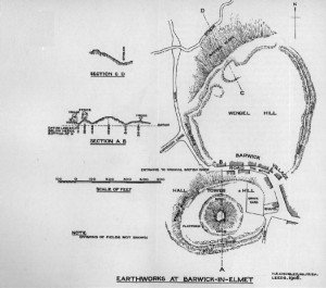
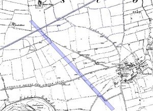
The cursus was originally about 2.1km long and aligned SE-NW. Clustered round the monument were a number of ring ditches, one that was excavated had a single burial with a beaker. This would date the site as being in use from around 3,500BC until at least the Bronze Age c.2,000 BC.

Stanwick Hill Fort

Stanwick is very close to the Scotch Corner junction of the A1, close to Darlington. From Scotch Corner, take the A66 towards Barnard Castle for a couple of miles then take the right turn towards Forcett. The road will take you past part of the defences, at which point a left turn will take you to Stanwick St John Church, which is a suitable starting point for any visit.

Maiden Castle Fort Reeth

For over five hundred years, the miners and smelters of Reeth produced mountains of precious lead. The lead ores from Reeth had high concentrations of Silver, Lead itself became and important ingredient in bronze. Maiden Castle, deep in the Swaledale lead mining territory a unique piece of Iron Age architecture. It is the only known fort with what seems to be a processional entrance.

Maiden Castle Fort Pooley Bridge

A superbly circular “fort”, built on the side of the hill, which seems to be a Brigantian fashion (see below). This is built with two rampart walls and a very narrow ditch between – 1-2m. If these were defences, they seem pretty slight. In it’s way, a miniature version of Wandlebury, but only about 200m circumference.

Greta Bridge Roman Fort

The fort lies between the River Greta and the Tutta Beck, just south of their junction, while the Rom,an Road skirts its northern edge, of which vestiges still remain in the gardens of the houses there.

East Witton Camp

The earthwork known in the National Trust inventory as East Witton Camp lies on the north-facing slope of Braithwaite Banks, only a couple of hundred metres uphill from Braithwaite Hall. It is a small, roughly oval Iron-Age enclosure that covers about two and a quarter acres (just under a hectare). We call Braithwaite Wood Fort Iron Age, but it’s actually undated, but its typology indicates a potential Iron Age origin.

Boltby Scar Iron Age Hill Fort

This Iron Age Hill Fort is mostly unrecorded and minimal information is available. A site visit is required to further understand the nature of the site. Note that both this, Roulston and Mam Tor have been dated at around 400BC.

Barwick in Elmet Iron Age Hill Fort

“The scale and function of the earthworks, which may comprise a rampart, a ditch and a counterscarp bank, is massive and assumed to be defensive though large univallate hillforts may have been built on the sites of earlier non-defensive enclosures such as slight univallate hillforts. In area large univallate hillforts vary between 1 and 10 hectares.

Cumbria

An aerial image of Castlerigg Stone Circle in Keswick, Cumbria. Part of a site report on brigantesnation.com

Cumbria’s dramatic landscapes are the product of a 500-million-year geological saga, punctuated by mountain-building, volcanic upheaval, limestone burial, tectonic extension and, finally, repeated ice-age sculpting. Today it can be divided into four broad physiographic regions.

North Yorkshire

The County of North Yorkshire is a small part of what was once a much larger collection of tribes in a confederation, called the Brigantes, and it is likely that they collectively followed a tribal system that recognised the deity Brigantia, and their supreme being.

Contact Us
close slider