Scholes (or Scoles) Coppice Camp (sometimes called “Caesar’s Camp”) lies just north-west of Kimberworth in Rotherham, atop the same Magnesian Read more
These are raised platforms created first and foremost for cult, procession, assembly or conversion—not for fortification or routine boundary-making. They Read more
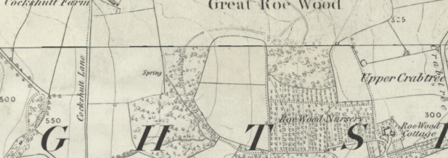
Great Roe Wood Enclosure
Great Roe Wood (often simply called “Roe Wood”) sits on the Magnesian Limestone ridge that carries the Roman Rig between Sheffield and Doncaster, just northeast of the village of Woodhouse (OS grid SK 450 920). This ridge forms a natural corridor overlooking the Don valley, with shallow soils over limestone giving way to deeper alluvial gravels in the valley bottom. The enclosure was lost when the Firth-Brown established their sportsground ( now owned by the Blades)
Structure
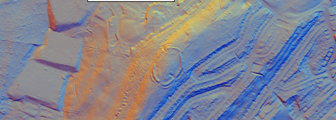
Historic Ordnance Survey maps and aerial photographs record a single-ditched enclosure in the northern part of Roe Wood, approximately 60 m across. Its boundary was defined by a narrow, shallow ditch—likely accompanied by a slight bank—cut into the limestone Drift.
Archaeological Investigations
No formal excavation report survives, as the enclosure was largely destroyed by woodland clearance and ploughing in 1922. Field observation in the late 20th century noted only the bases of the ditches visible as earthwork stubs beneath the tree canopy (researchframeworks.org). South Yorkshire Archaeology Service trials during evaluation of the adjacent Roman Rig pipeline detected only sterile subsoil within the presumed enclosure area, with no finds to refine its date.
Date & Interpretation
On typological grounds—its simple single-ditched plan and small size—the Roe Wood enclosure is provisionally assigned to the later Iron Age or Romano-British period, forming part of a wider pattern of upland territorial markers that includes hilltop forts, linear dykes and field systems along the Magnesian Ridge (researchframeworks.org). Its destruction means we lack secure dating evidence, but its proximity to the Roman Rig suggests it may have functioned as a minor defended farmstead or livestock pen under Brigantian or later Romano-British control.
Relationship with the Roman Rig
Great Roe Wood’s enclosure lay just a few hundred metres from the Rig’s ridge-top earthwork. Together, they formed a composite frontier landscape, with the Rig marking a broad territorial boundary and the enclosure providing a local strongpoint or livestock refuge. Although no direct structural connection survives, their parallel orientation and shared geology imply coordinated construction and use within the same defensive network.
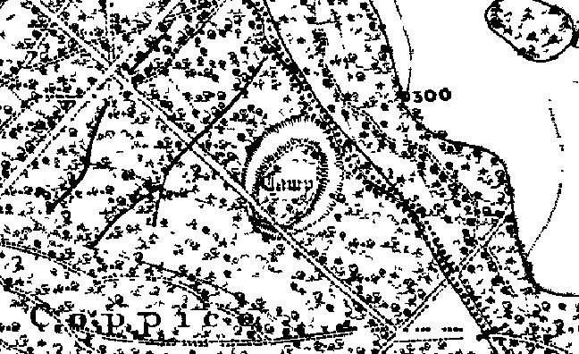
XXXII. The Earthwork in Roe Wood
About quarter of a mile to the north-east of Shirecliffe Hall, Pitsmoor, is a wood known as Great Roe Wood. Near its western edge is a nameless earthwork, hitherto little noticed, but once or twice described as a "camp." This earthwork originally consisted of one large circular mound and an outer ditch. It is not nearly so well preserved as the earthwork at the top of Wincobank wood, for only portions of the mound and ditch now remain. It is upon a hill side which slopes to the east, not upon the summit of the hill, and there is no ancient road near.
With the help of the Rev. W. S. Sykes I examined and measured this earthwork in November, 1893. There are three distinct portions of the mound and ditch now remaining, the most perfect of these being on the east side. Here the mound and ditch are in their original form, and they exactly resemble the larger and inner mound and ditch of the earthwork in Wincobank wood. The other portions are on the south-east and south-west sides. These are only small pieces, but by their help, and by the help of the fainter traces of the enclosed space still existing, it is possible to make out the original plan. The enclosed area is flat. We took the following measurements:
Diameter of the enclosed area measured from north to south - 200 feet
Diameter of the enclosed area measured from east to west - 190 feet
Inside height of the mound on the east side - - - - 5 feet
Perpendicular depth of ditch - - - - - - - 6 feet
Width of ditch measured from margin to margin in the three places where it is preserved - 30 feet
It will thus be seen that the ditch corresponds in width and depth to the larger ditch of the camp at Wincobank, and to that of The Ridgeway.
Mr. Winder tells me that, according to plans in the Duke of Norfolk's office, there has been no alteration in the size or shape of Great Roe Wood for the last hundred years, and he says that the largest oak tree he ever saw was felled in it. The six-inch Ordnance map of 1850 marks a spring on the site of the earthwork, though this seems to have been carried away by draining; at all events it is not there now.
There can be no doubt as to the antiquity of this earthwork, which seems to have been the site of a protected clan homestead of some old Germanic, or rather Cimbric or Celtic family. Tacitus, as is well known, describes the old Germans not as dwelling in towns, but as inhabiting dwellings scattered here and there in the fields and woods. "Every man," he says, "surrounds his house with a spatium," whatever that may mean.[1] The names of places in England ending in tan, wura, etc., show that the enclosed or protected homestead was common here, and what protection could have been better, when stone buildings and castles were not, than an encircling mound of earth and a big ditch?
It seems to be almost an instinct in an Englishman to surround himself, if not with a great earth mound, at all events with a big garden wall. The children who make mounds and ditches for their houses on the sea shore are perhaps, unconsciously and by instinct, repeating what their forefathers did ages ago, and what their fathers still do when they build great walls round their parks and gardens, not to shut out their enemies or beasts of prey, but for reasons best known to themselves.
Footnotes
[1] Germ. 16. As to the word spatium see ante p. 246.
A Probable Neolithic flint piece of debitage possbily intended to be a blade.The fragment is made from a tertiary flake of semi-glossy light grey flint with slightly darker grey patches. It is sub-triangular in plan [...]
A very worn and chipped Roman copper alloy radiate of uncertain emperor dating to the period AD 260-275 (Reece period 13). Unclear reverse type depicting figure standing left. Unclear mint. [...]
A heavily worn Medieval silver 'short cross' cut farthing of an uncertain monarch, Henry II to Henry III dating to the period c.1180-1247. Not further defined.Length: 9.6mm; width: 9.4mm; thickness: 0.5mm; weight: 0.4g. [...]
Silver medieval penny of an uncertain ruler, probably Henry V to Henry VI (1413 - 1461) minted at York. The coin is in poor condition, is 16mm in diameter and weighs 1.00g. [...]
A Roman copper-alloy radiate of Tetricus I/II dating to circa AD 271-274 (Reece Period 13). PAX AVG reverse type depicting Pax standing left holding branch and vertical sceptre. Gallic Mint I. [...]
A Roman copper-alloy nummus of Magnentius or Decentius dating to AD 250-253 (Reece Period 18). VICTORIAE DD NN AVG ET CAE reverse type depicting two Victories holding wreath inscribed [VOT/V/MVLT/X]. Mint of Trier. [...]
A Roman silver denarius of Antoninus Pius (AD 138-161) dating to AD 154-155 (Reece Period 7). COS [IIII] reverse type depicting Fortuna, draped, standing right, holding rudder, vertical on globe, in right hand and cornucopiae, with tip [...]
A Roman copper-alloy barbarous radiate copying a coin of Victorinus (AD 268-270) dating to circa AD 275-285 (Reece Period 14). Copying PAX AVG reverse type depicting Pax standing left holding branch and transverse sceptre. Unclear [...]
A Roman copper-alloy radiate of Carausius (AD 286-293) dating to circa AD 286-293 (Reece Period 14). PAX AVG reverse type depicting Pax standing holding branch and vertical sceptre. Unclear mint. [...]
A Roman copper alloy radiate of Tetricus II (AD 272-274) dating to circa AD 272-274 (Reece Period 1). [SPES AVG] reverse type depicting Spes walking left holding branch and raising hem of robe. Unclear mint. [...]
A free-standing pierced stone weight of uncertain age, but probably dating to the Post Medieval period.The object is sub-square in plan and rectangular in cross section. Its sides appear to have been sanded to give [...]
A Roman copper-alloy barbarous radiate copying a coin of Divus Claudius II (AD 270-271) dating to circa AD 275-285 (Reece Period 14). Copying CONSECRATIO reverse type depicting altar with crescent. Unclear prototype mint. [...]
A free-standing cast lead conical 12.43g weight of uncertain age, but probably dating to the Post Medieval period.It has a sub-circular base with concave tapering sides up to a slightly flattened apex. A circular hole runs through [...]
A free-standing cast lead conical 20.79g weight of uncertain age, but probably dating to the Post Medieval period.It has a sub-circular base with tapering sides up to a slightly flattened apex. A circular hole runs through the [...]
A clipped Post Medieval silver halfgroat of James I (AD 1603-1625). First coinage, dating to AD 1603-1604. Mint of London. North (1991: 144) No. 2076, thistle mintmark. [...]
A very worn Post Medieval silver three pence of Elizabeth I (AD 1558-1603) second coinage dating to AD 1561-1582. Mint of London. Unclear initial mark. North (1991: 135) no. 1998. [...]