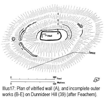
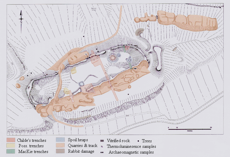
Archaeologists have suggested ways to organise the very varied “vitrified forts” into formal classes – especially schemes that distinguish forts Read more
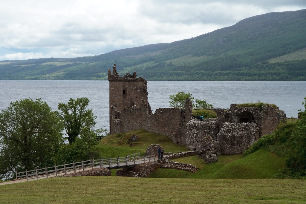
It was during a trip to.Scotland, in the Summer of 1997, that I first heard of vitrified hillforts. It was Read more
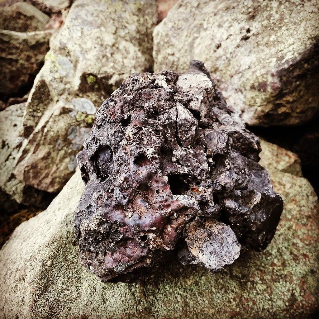
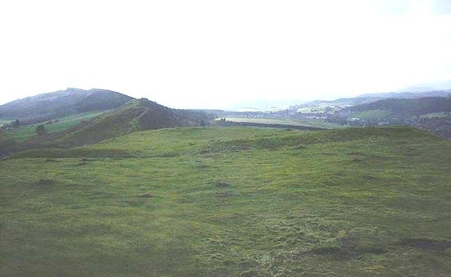
This image is from the Megalithic Portal, image links to their site reference page.
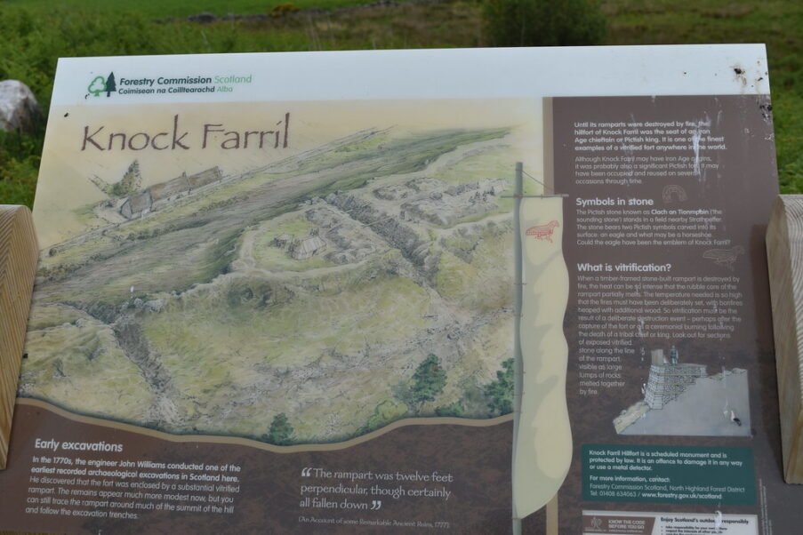
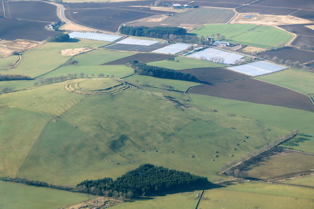
Knockfarrel is a remarkably intact vitrified fort whose very first trenches helped launch Scottish field archaeology. Beneath the fused rampart and distinctive wing-walls almost everything – date, occupation density, reason for firing – remains conjectural. A light-touch programme of dating and geophysics could transform this iconic ridge-top from a picturesque curiosity into a chronologically-anchored keystone of Highland prehistory.
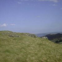
Knockfarrel / Knock Farril – the vitrified fort of Strathpeffer
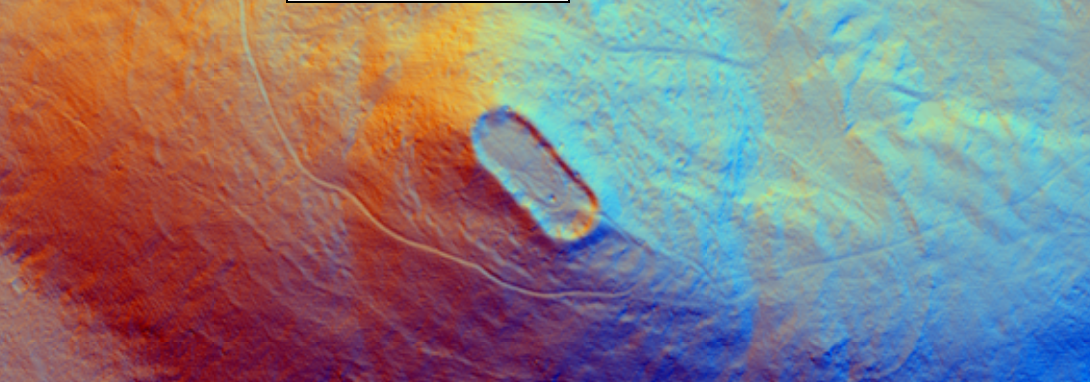
Setting & ground plan
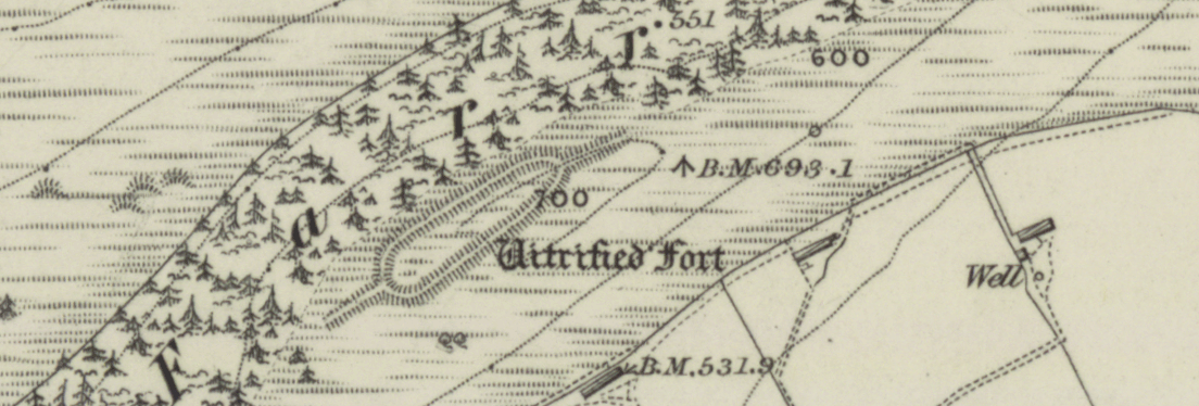
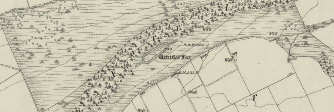
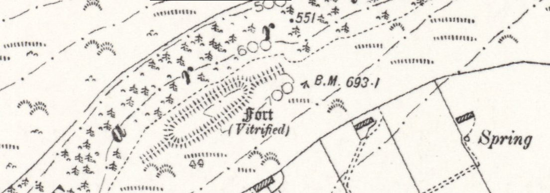
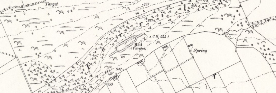
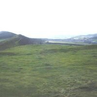
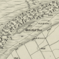
Location – Grid ref. NH 5045 5850; the fort crowns the ENE tip of the long Druim Chat ridge above Strathpeffer, 214 m a.s.l., overlooking the Cromarty Firth and the Beauly corridor. (Canmore)
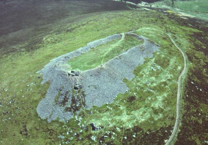
Core enclosure – Lozenge-shaped interior ≈ 118 m × 30 m (0.33 ha) bound by a single timber-laced wall c. 4-5 m thick. The fabric is heavily vitrified all the way round, with glassy basaltic slag up to 0.6 m deep. (hillforts.arch.ox.ac.uk, her.highland.gov.uk)
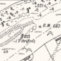
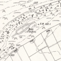
Wing-walls / outworks – At each end a spine-like wing-wall runs a further 50 m along the ridge crest, visually doubling the length of the fort and creating ‘look-out posts’ highlighted in the scheduling statement. (hillforts.arch.ox.ac.uk, Historic Environment Scotland)
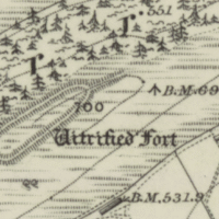
Entrances & trenches – No faces survive, but topography and early sketches suggest the main entrance lay on the gentler south-west approach; three straight cuts visible today are the scars of 18th-century trenches, not prehistoric ditches. (Canmore, her.highland.gov.uk)
Timeline of investigation
Year(s)
Who & what
Key contribution
c. 1770–77
John Williams cut three broad sections – probably the first archaeological excavation in Scotland.
Confirmed wall was fused in situ; proposed drawbridge-style gap between end-walls and main rampart. (Ross and Cromarty Heritage, Canmore)
1905 & 1918
F. Fraser and J. Wallace publish detailed measured plans.
No modern intrusive excavation has taken place since Williams’ trenches.
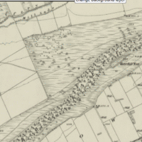
Knockfarrel Fort - OS Series 1 - National Library of Scotland
Knockfarrel Fort - OS Series 1 - National Library of Scotland
Knockfarrel Fort - OS 6inch 1915 - National Library of Scotland
Knockfarrel Fort - OS 6inch 1915 - National Library of Scotland
Key physical & scientific observations
Vitrification style – Blocks display vesicular green-black glass and casts of vanished timbers, indicating temperatures > 1100 °C under oxygen-limited firing. (archhighland.org.uk)
Look-out posts – The flanking wing-walls terminate on slight knolls that may have carried watch-huts; this pairing of a compact core with outlying sentry posts is unique among Highland vitrified forts. (Historic Environment Scotland)
Inter-visibility network – Lines of sight link Knockfarrel to Ord Hill and Craig Phadrig across the Moray Firth, suggesting the ridge formed part of an Iron-Age/Pictish signalling chain. (The Modern Antiquarian)
Chronology & cultural horizon
Direct dating is still absent, but comparative morphology and the regional pattern of vitrified forts point to mid-Iron-Age construction (c. 400–200 BC). The strategic siting and later Pictish reuse of similar forts have led some scholars to propose an early-medieval re-occupation phase, though this remains to be tested. (her.highland.gov.uk, ancientworlds.net)
Why Knockfarrel matters
Type-site for vitrification studies – Williams’ 1770s trenches made the fort a cradle of Scottish archaeological science.
Exceptional Preservation – Continuous slag outcrops provide stable faces for micro-CT, geochemical or archaeomagnetic sampling.
Landscape dominance & signalling – The ridge-top design plus twin look-outs offer a textbook case for research into prehistoric communication networks.
Knockfarrel (Gaelic, cnoc, hill; faire, watch, or guard)
This had substantial ramparts made of stones with a timber frame, enclosing a large area and making good use of the natural defences of the hill-top. At some time, the timber of the walls was set on fire, creating enough heat to melt the rock. This vitrification can be seen all around the perimeter of the fort.
A complete silver Scottish twelve shillings coin of James VI of Scotland and I of England, eighth coinage post-dating accession to English throne, dating to 1603-1625, Lys initial mark. Reverse has a shield with arms of [...]
A silver Post-Medieval shilling of Elizabeth I, third issue with ‘A’ initial mark dating to 1583-1585. Mint of London. As North Vol 2, p.136, no.2014. [...]
A lead alloy pipe tamper dating to the 17th century. The plate has moulded decoration to both sides depicting Charles I (facing right) and Henrietta Maria of France (facing left). Both images are contained in [...]
A damaged lead-alloy Medieval pilgrim's ampulla, 50mm in length and 35mm wide, with a round bodied flask with a flaring open top which is partially complete. One side of the flask body has traces of moulded [...]
An incomplete Medieval cast copper alloy buckle plate, dating to c. AD 1100-1400. The plate is missing its buckle and part of its sprues. The buckle plate is sub-rectangular in plan. Projecting from one long edge [...]
A Roman copper-alloy nummus of the House of Valentinian , dating to AD 364-7 (Reece Period 19), GLORIA RO-MANORVM reverse type depicting the emperor with right hand dragging captive right and holding a labarum in left hand. Mint of [...]
A Post-Medieval copper alloy farthing of Charles I (AD 1625-1649), dating to AD 1636-1644. Rose type 2, with sceptres in saltire through single crown. Mint of London. Unclear initial mark. North (1991: 165) no. 2291. [...]
A clipped and heavily worn Roman copper alloy nummus of Gratian (AD 367-383) dating to the period AD 367-378 (Reece period 19). SECURITAS REI PUBLICAE reverse type depicting Victory advancing left, holding a wreath and palm. Unknown mint. [...]
A silver Roman siliqua of Honorius (AD 393-423) dating to the period AD 397-402 (Reece Period 21) minted in Milan VIRTVS ROMANORVM reverse type depicting Roma seated left on cuirass, holding Victory on globe and spear. Hoxne, p. 145, no. [...]
An incomplete Roman composite plate brooch probably dating to AD 100-200. The brooch is missing it's pin and part of the top and bottom circles. The brooch is flat in cross section and probably originally consisted of [...]
Fragment from a probable buckle frame dating to the Post Medieval period (c.AD 1720-1790). The fragment is broadly rectangular in plan and includes a short section of the corner of the buckle frame. The fragment includes the [...]
Fragment from a buckle frame dating to the Post Medieval period (c.AD 1720-1790). The fragment is broadly C shaped in plan and D shaped in profile. It consists of two corners and one side of a sub-rectangular [...]
A complete copper alloy bovine (bull's head) vessel / bucket mount, dating to the Roman period (c. AD 50-200).The cast copper alloy mount is a sub-inverted triangle with a pointed lower tip and slightly waisted sides to form the nose.The [...]
An incomplete copper-alloy early Medieval stirrup strap mount of uncertain or unclassified type, dating to c.AD 1050-1150. The central part of the object survives with parts of the open work broken off on all sides except [...]
A near complete Medieval-Post Medieval cast copper alloy buckle with integrated plate dating to the period c.AD 1250-1500. The buckle is missing its pin.It has a rectangular frame, which has a sub rectangular cross-section. The integral plate has [...]
A very worn copper-alloy Roman radiate or nummus of unclear ruler dating to AD 260-402. Unclear reverse type, unclear mint.The coin is chipped around its circumference. [...]
A very worn Roman copper alloy radiate of uncertain emperor dating to the period AD 260-275 (Reece period 13). Unclear reverse type depicting. Unclear mint. [...]
An incomplete Medieval cast copper-alloy rectangular buckle with integral looped plate, dating to c. AD 1200-1400. The buckle is missing its pin. The buckle comprises a rectangular loop and an integral plate. The plate is made [...]


 Wing-walls / outworks – At each end a spine-like wing-wall runs a further 50 m along the ridge crest, visually doubling the length of the fort and creating ‘look-out posts’ highlighted in the scheduling statement. (hillforts.arch.ox.ac.uk, Historic Environment Scotland)