"We were shocked to discover such a huge complex," said Alastair Oswald, archaeological field investigator for English Heritage. Preliminary examinations Read more
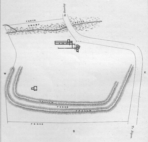
This earthwork was partially excavated in 1870, these revealed the foundations for a Roman villa of obvious opulence. It's final Read more
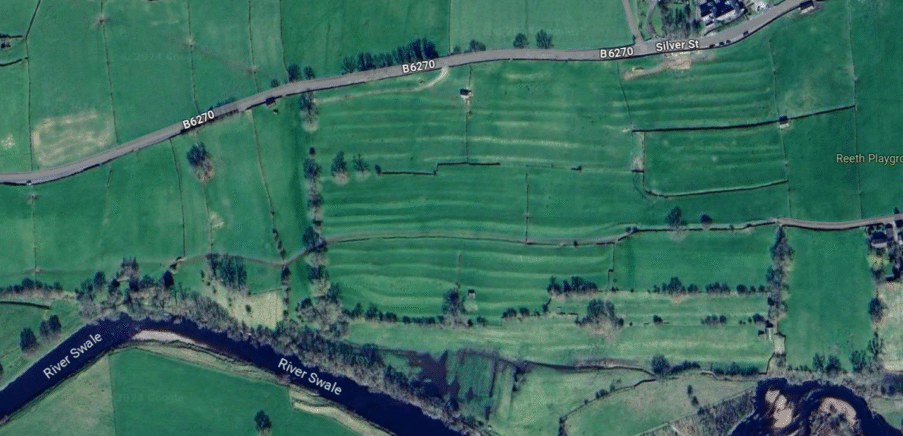
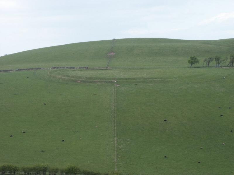
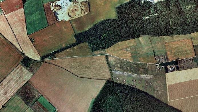
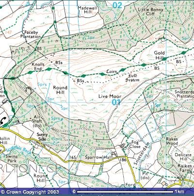
The field systems at Reeth are particularly noted for their historical coaxial layout, and are characterized by long, parallel boundaries that run across the landscape, a pattern indicative of significant central organization and planning. The existence of such extensive field systems suggests a highly structured society with considerable agricultural activity. Dating back to the Iron Age and the Romano-British period, these field systems are part of a broader landscape of small farmsteads and fields that once dotted the area. The coaxial field boundaries, often defined by stone banks or lynchets, are aligned at right angles to the slope, creating a distinctive geometric pattern visible in the terrain. This alignment facilitated the management of water run-off and soil erosion, essential for the cultivation of crops in the hilly terrain of Swaledale. The field systems extend across the pastures of modern farms and reach up to the moorlands, indicating the expansive nature of these ancient agricultural practices. The field systems near Reeth, particularly those on the higher elevations like Fremington Edge, have largely been preserved, allowing for a glimpse into the prehistoric landscape. Research conducted by the Swaledale and Arkengarthdale Archaeology Group (SWAAG) has provided valuable insights into the age of the field systems found at Reeth. The Fremington Project, specifically, has focused on an open settlement landscape of Late Prehistoric/Romano-British character centred on the pastures of Hagg Farm, near Reeth. This landscape includes a complex of small farms and fields, which are part of a coaxial field system, characterized by parallel boundaries sharing a common axis. Although these settlements have not been dated by excavation, their resemblance to other Late Prehistoric/Romano-British landscapes in the region suggests a similar time frame. Additionally, the archaeological landscapes of Reeth Moor have been studied, revealing a Palimpsest of sites from various periods, including the Post-Glacial period through to the Native Roman and Medieval times. For a broader understanding of England's field systems, a project funded by Historic England has collated and analysed scientific dates from over 120 excavated field systems, providing a comprehensive overview of the chronologies involved.
A complete silver Scottish twelve shillings coin of James VI of Scotland and I of England, eighth coinage post-dating accession to English throne, dating to 1603-1625, Lys initial mark. Reverse has a shield with arms of [...]
A silver Post-Medieval shilling of Elizabeth I, third issue with ‘A’ initial mark dating to 1583-1585. Mint of London. As North Vol 2, p.136, no.2014. [...]
A lead alloy pipe tamper dating to the 17th century. The plate has moulded decoration to both sides depicting Charles I (facing right) and Henrietta Maria of France (facing left). Both images are contained in [...]
A damaged lead-alloy Medieval pilgrim's ampulla, 50mm in length and 35mm wide, with a round bodied flask with a flaring open top which is partially complete. One side of the flask body has traces of moulded [...]
An incomplete Medieval cast copper alloy buckle plate, dating to c. AD 1100-1400. The plate is missing its buckle and part of its sprues. The buckle plate is sub-rectangular in plan. Projecting from one long edge [...]
A Roman copper-alloy nummus of the House of Valentinian , dating to AD 364-7 (Reece Period 19), GLORIA RO-MANORVM reverse type depicting the emperor with right hand dragging captive right and holding a labarum in left hand. Mint of [...]
A Post-Medieval copper alloy farthing of Charles I (AD 1625-1649), dating to AD 1636-1644. Rose type 2, with sceptres in saltire through single crown. Mint of London. Unclear initial mark. North (1991: 165) no. 2291. [...]
A clipped and heavily worn Roman copper alloy nummus of Gratian (AD 367-383) dating to the period AD 367-378 (Reece period 19). SECURITAS REI PUBLICAE reverse type depicting Victory advancing left, holding a wreath and palm. Unknown mint. [...]
A silver Roman siliqua of Honorius (AD 393-423) dating to the period AD 397-402 (Reece Period 21) minted in Milan VIRTVS ROMANORVM reverse type depicting Roma seated left on cuirass, holding Victory on globe and spear. Hoxne, p. 145, no. [...]
An incomplete Roman composite plate brooch probably dating to AD 100-200. The brooch is missing it's pin and part of the top and bottom circles. The brooch is flat in cross section and probably originally consisted of [...]
Fragment from a probable buckle frame dating to the Post Medieval period (c.AD 1720-1790). The fragment is broadly rectangular in plan and includes a short section of the corner of the buckle frame. The fragment includes the [...]
Fragment from a buckle frame dating to the Post Medieval period (c.AD 1720-1790). The fragment is broadly C shaped in plan and D shaped in profile. It consists of two corners and one side of a sub-rectangular [...]
A complete copper alloy bovine (bull's head) vessel / bucket mount, dating to the Roman period (c. AD 50-200).The cast copper alloy mount is a sub-inverted triangle with a pointed lower tip and slightly waisted sides to form the nose.The [...]
An incomplete copper-alloy early Medieval stirrup strap mount of uncertain or unclassified type, dating to c.AD 1050-1150. The central part of the object survives with parts of the open work broken off on all sides except [...]
A near complete Medieval-Post Medieval cast copper alloy buckle with integrated plate dating to the period c.AD 1250-1500. The buckle is missing its pin.It has a rectangular frame, which has a sub rectangular cross-section. The integral plate has [...]
A very worn copper-alloy Roman radiate or nummus of unclear ruler dating to AD 260-402. Unclear reverse type, unclear mint.The coin is chipped around its circumference. [...]
A very worn Roman copper alloy radiate of uncertain emperor dating to the period AD 260-275 (Reece period 13). Unclear reverse type depicting. Unclear mint. [...]
An incomplete Medieval cast copper-alloy rectangular buckle with integral looped plate, dating to c. AD 1200-1400. The buckle is missing its pin. The buckle comprises a rectangular loop and an integral plate. The plate is made [...]


 The field systems at Reeth are particularly noted for their historical coaxial layout, and are characterized by long, parallel boundaries that run across the landscape, a pattern indicative of significant central organization and planning. The existence of such extensive field systems suggests a highly structured society with considerable agricultural activity.
  Dating back to the Iron Age and the Romano-British period, these field systems are part of a broader landscape of small farmsteads and fields that once dotted the area. The coaxial field boundaries, often defined by stone banks or lynchets, are aligned at right angles to the slope, creating a distinctive geometric pattern visible in the terrain.
  This alignment facilitated the management of water run-off and soil erosion, essential for the cultivation of crops in the hilly terrain of Swaledale. The field systems extend across the pastures of modern farms and reach up to the moorlands, indicating the expansive nature of these ancient agricultural practices. The field systems near Reeth, particularly those on the higher elevations like Fremington Edge, have largely been preserved, allowing for a glimpse into the prehistoric landscape.
 Research conducted by the Swaledale and Arkengarthdale Archaeology Group (SWAAG) has provided valuable insights into the age of the field systems found at Reeth. The Fremington Project, specifically, has focused on an open settlement landscape of Late Prehistoric/Romano-British character centred on the pastures of Hagg Farm, near Reeth. This landscape includes a complex of small farms and fields, which are part of a coaxial field system, characterized by parallel boundaries sharing a common axis. Although these settlements have not been dated by excavation, their resemblance to other Late Prehistoric/Romano-British landscapes in the region suggests a similar time frame. Additionally, the archaeological landscapes of Reeth Moor have been studied, revealing a Palimpsest of sites from various periods, including the Post-Glacial period through to the Native Roman and Medieval times. For a broader understanding of England's field systems, a project funded by Historic England has collated and analysed scientific dates from over 120 excavated field systems, providing a comprehensive overview of the chronologies involved.


