

Despite is unusually high position, this fort contains traces of a number of huts, and on investigation these have yielded plentiful pottery, as well as charcoal giving a surprisingly early radio carbon date
Despite is unusually high position, this fort contains traces of a number of huts, and on investigation these have yielded plentiful pottery, as well as charcoal giving a surprisingly early radio carbon date

Located in East Scrafton, a small hill called Lady Hill is marked on the OS Series 1 map. The term “Lady” is of interest, since it has been used elsewhere in sites that appear important for religious purposes.

In the field of Bridge Barn, close to Nathwaite Bridge, there are two fords marked on the OS Series 1 map. This site page holds the details of our investigation into the fording point we think may be called Cow Ford.
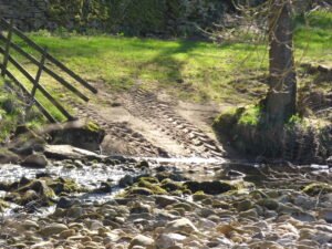
In the field of Bridge Barn, close to Nathwaite Bridge, there are two fords marked on the OS Series 1 map. This site page holds the details of our investigation into the fording point we think may be called Intach Ford.

Located in the same field as Bridge Barn, close to the Cow Ford, there is a mound. In may be around 4-5m in diameter and perhaps 1.5-2m high. Our initial search drew a blank as to what it may be. But it’s proximity to Cow Ford suggests it may have a mining, or masonic origin.

Nathwaite bridge over the River Cover is a strategically placed river crossing, for centuries it has been the only crossing point over the river Cover, and with a fortified barn right next door to it, this is an enigmatic site worthy of closer attention.
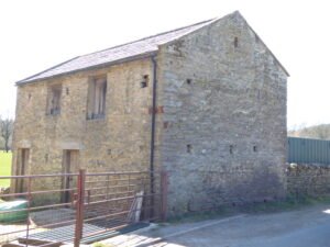
The barn that is located closest to Nathwaite Bridge seems important, but is poorly understand and recorded. It’s position, in close proximity to the bridge, together with three arrow-slot style defensive features indicate it may have served to protect the Carlton side of the river from raiders, and is in a perfect position, strategically. Yet, it is not recorded as such, and may be later in its creation, as it does not appear on some earlier maps.

Geophysics and three hand-excavated trenches uncovered ten further uprights, in addition to the known standing stone at Farley Moor Woods, lying just below the leaf-litter, defining a ring c. 18 m in diameter around the visible stone. A low stone-built platform or “kerb cairn” occupies the circle’s south-eastern arc; charcoal lenses and a smashed Collared-Urn sherd in its make-up gave an early Bronze-Age radiocarbon estimate of c. 1700 BCE (3,700 cal BP).

Brigantia Espania is our name for our Spanish Brigantian research pages and sites. This is the beginning of our journey, and we start at the beginning.

Hutton Rudby was once known as Hutton-juxta-Rudby, or Hutton-nigh-Rudby, because it is really two villages: Hutton and Rudby, separated from each other by the River Leven. How old is the village? There have been people living here for thousands of years. Stone Age tools have been found in North End.
 NLS Map Explorer
 Google Earth
 Google Maps
 Lidar Finder
 TMA
TMA
 Megalithic Portal
 Yorkshire Arch. Air Mapping
 ADS
ADS
 Brigantian Adventure FB Group
Stone Bothering FB Group
Stone Faces FB Group
Brigantian Adventure FB Group
Stone Bothering FB Group
Stone Faces FB Group
 Heritage Gateway
 ARCHI® MAPS: UK
 Atlas of Hillforts
 Portable Antiquities
 British History Online
Brigantes Nation FB Group
British History Online
Brigantes Nation FB Group

