Knockfarrel, Ross and Cromarty

Knockfarrel

Knockfarrel (Gaelic, cnoc, hill; faire, watch, or guard)
Ross & Cromarty
2 1/2 miles west of Dingwall
NH 505585

Vitrified Fort

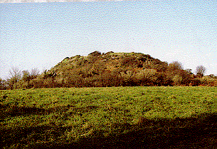
This had substantial ramparts made of stones with a timber frame, enclosing a large area and making good use of the natural defences of the hill-top.. At some time, the timber of the walls was set on fire, creating enough heat to melt the rock. This vitrification can be seen all around the perimeter of the fort.

Mote of Mark, Dumfries

Mote of Mark

Mote of Mark, Rockcliffe.
Dumfries & Galloway
4 miles south of Dalbeattie
NX 845540

Vitrified Fort

The Mote of Mark is a defended hilltop overlooking the Urr estuary. It was the court or citadel of a powerful Dark Age chieftain, possibly one of the princes of Rheged. The site was occupied during the 6th century and appears to have been destroyed by fire in the 7th century.

The top of the hill was enclosed by a massive stone and timber rampart. Inside was a timber hall surrounded by a huddle of workshops and stables. This was a wealthy site with trading contacts across Europe. Finds from the excavations include glass beads and wine jars from central France and glassware from Germany. Local craftsmen produced elegant bronze jewelry in a distinctive Celtic style.

The tumbled remains of the ramparts can still be seen and an on-site interpretation panel has an atmospheric reconstruction of the fort.

size: 8 ha (20a)

Legendary and Literary Background – https://panther.bsc.edu/~arthur/others.html
This fort was occupied from the 5th to 7th centuries, smack dab in the Arthurian time frame. At the pinnacle of its prominence, it was a well-fortified trading and manufacturing center. Excavations in 1913 and 1973 unearthed a large, circular timber hut and evidence of metalworking. These people seemed to have imported raw materials–iron from the Lake District and jet from York–to produce interlaced jewelry, brooches, and sundry metalwork. They imported luxuries as well–pottery from Bordeaux and glass from the Rhineland were found. Such prosperity suggests that this fort may have been the stronghold of a smaller British subkingdom.

The primary defences consisted of stone and timber walls, and there was a timber gate for the main entrance on the southern slopes. In the 7th century, though, these defences failed. The outer wall shows evidence of vitrification, a condition when extreme heat causes stones to fuse together. Many believe that this was the result of an attack by the Angles–Anglian runic inscriptions were found at the site–though some say that the walls were purposely vitrified to strengthen them.

The only thing truly connecting this fort with the Arthurian legend is the name, its period of occupation, and its proximity to Trusty’s Hill.

Eileen na Goar, Highlands

Eileen na Goar


Eileen na Goar is a large vitrified fort, situated on the island at the entrance of Loch Ailort.

This island, locally termed Eilean na Goar, is the most eastern and is bounded on all sides by precipitous gneiss rocks; it is the abode and nesting place of numerous sea birds. The flat surface on the top is 120 feet from the sea level, and the remains of the vitrified fort are situated on this, oblong in form, with a continuous rampart of vitrified wall five feet thick, attached at the SW end to a large upright rock of gneiss. The space enclosed by this wall is 420 feet in circumference and 70 feet in width. The rampart is continuous and about five feet in thickness. At the eastern end is a great mass of wall in situ, vitrified on both sides. In the centre of the enclosed space is a deep depression in which are masses of the vitrified wall strewed about, evidently detached.

Finavon, Angus

Finavon, Angus

.


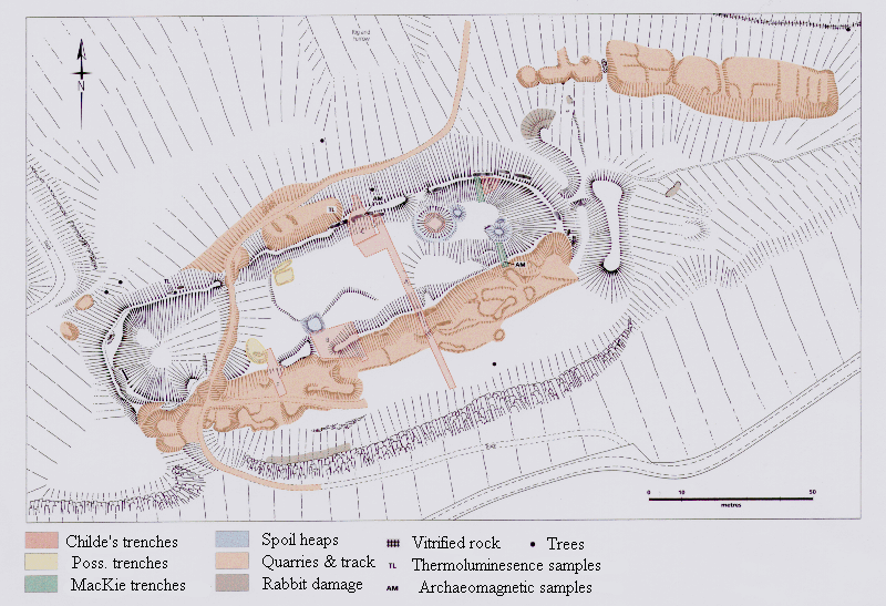
Finavon Hill has attracted a great deal of archaeological interest from antiquarians and archaeologists over the years especially since it displayed traces of vitrified rock. It was planned 100 years ago by David Christison and was subject to extensive excavations undertaken by Prof. Gordon Childe between 1933-5. That the fort had been burnt was clearly attested not only by the vitrified material but also by the charred timbers located during the excavation. The fort could also be readily compared to other oblong forts and was, therefore, targeted for scientific dating techniques including radiocarbon dating, thermoluminesence and archaeomagnetic dating.

A survey plan of the fort was undertaken using a variety of techniques. The fort is c. 155m long by c.55m wide. There is a T-shaped outwork at the eastern end. As described by Childe the southern side of the fort sits back at least 20m from the cliff edge. In addition at the western end it extends to incorporate a natural depression. In both cases the apparent disregard for the natural topography as a line for the ramparts surely indicates that the practical need for a defensive position was not the a primary reason behind the construction of the fort. Indeed the need to obtain an oblong shape, despite the topographic variations, suggests that this may have been as much an issue in the minds of the builders. It is also possible that the inclusion of the natural hollow at the western end may

have been of some significance, perhaps related in use to the well at the eastern end.

The fort and its immediate surroundings have been subject to a great deal of quarrying which has had a profound effect on the nature of the remains and can be very confusing when visiting the site. Three main areas of quarrying can be identified on the hill: the entire southern side of the southern rampart; a small section into the exterior off the northern rampart; and an extensive set along the north-eastern face of the hill outside the fort.

Although in general the state of preservation of the features can be described as stable there are a number of small areas of active erosion. The areas effected by the quarrying and the excavations are the most unstable and most prone to erosion. Particularly noticeable is the loose stone work in what was Childe’s trench D or the eastern end of the main quarry in along the southern rampart. Animal activity on the site appears to be relatively restricted although there are a large number of mole hills on the southern terrace.

Excavations carried out in 1933-4 by Childe (1935) showed that the wall was about 20′ thick and that it stood 12′ internally and 16′ externally beneath the grass-grown rubble. There was a row of dwellings with hearths under the shelter of the N wall. Pot-making, spinning and metal-working were carried out in the lee of the S wall. The finds, including gritty plain potsherds, stone whorls, flints, an iron ring, and a thick jet ring, are in the NMAS (Acc. Nos: AO 104, BE 480, HH 386-416).
In 1966 MacKie dug two trenches against the inner faces of the N and S ramparts, and three radio-carbon dates were obtained – c. 390, c. 480, and c. 665 BC – indicating that the fort was in use from the 7th century BC until at least the late 5th or early 4th century before being destroyed.

“This is a typical vitrified fort, so far as such a thing can be said to exist, and is unusually accessible. It was investigated by excavation in the early 1930s, so more details are known of its construction than of most others.

It was defended by a single massive wall, now heavily vitrified, enclosing 0-4 hectare. The plan seems to be the result of deliberate setting out, parallel-sided with semicircular ends, and pays little regard to the form of the ground. There is a further arc of walling outside the east end, linked to the main enclosure by a straight axial line of wall (cf. Castle Law, Forgandenny); this is now slightly lower than the ramparts which it links. There is also a horn of vitrified material projecting at the east end of the south wall. These features were not investigated. There is a rock-cut well in the enclosure, and a deep hollow which may also have been a
water hole at the west end. The ramparts have been broken through by a modern track, but no ancient entrance can be identified.

Excavation showed that the wall was 6 metres thick, and it was estimated originally to have stood 3-6 metres high internally and 4-9 metres high externally, having been built on a slope. On the inner face, at a height of 2-4 metres, the wall face was set back about 0-7 metres, and wherever tested remains of burned timbers were found against the inside of the rampart. It seems that the whole circuit must have been lined with timber buildings. Some very coarse pottery was found. More recently, radiocarbon dating of these burned remains indicated a date of probably between 400 and 600 BC for their construction.” – A.H.A. Hogg – Hill=Forts of Britain.

V. G. Childe, Proc. Soc. Ant. Scot. LXIX (1934-5), pp. 49-80

(excavation); LXX (1935-6), pp. 347-52 (minor additional

details).

E. W. MacKie, Antiquity XLIII (1969), p. 17 (radiocarbon

dating).

PP, pi. 56 (air photo).
Wincobank, South Yorkshire

Wincobank – Sheffield

1903 OS map of Wincobank

Location

Wincobank (W.R.), Hillfort (SK/378910)
2.5 miles NE of center of Sheffield. Finds in Sheffield Museum.

Description

“This is an oval fort with an internal area of 2.5 acres. A bank, ditch and counterscarp bank are continuous around it except on the N side where ditch and counterscarp have been destroyed. The banks now nowhere exceed 3 ft. in ht. There is an entrance on the NE side, where one end of the main bank is thickened and the other end runs out across it for 30 ft., forming a type of out turned entrance.

Excavation in 1899 showed that the ditch had an original depth of 5-6 ft. The main bank has a rubble core with stone facings. It had contained much timber work holding it together; at some period this had been burnt, accidentally or otherwise, until much of the rampart had been fused into a solid mass by heat. Not dated.” – N Thomas, Guide to Prehistoric England.

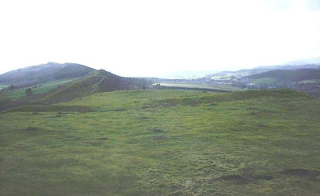
Part of the southern Rampart, and the view to the south from Wincobank

“The oval 2.5 acre fort at Wincobank, north of Sheffield, almost certainly provides an example of timber-laced rampart construction. Excavations in 1899 (Howarth, 1899) indicated that the internal rampart, surviving to a height of about 3 feet, was 18 feet wide, and had well-built stone revetments. The core was of sandstone rubble, badly burnt and in parts fused, with variable quantities of charcoal and burnt timber. There was an outer earthen rampart with a little burnt wood and burnt stones, and a ditch between the two ramparts. No material remains were found.” Later Prehistory from the Trent to the Tyne. Challis and Harding 1975.

Research notes

Wincobanks virtrified inner rampart.

Site visit notes – George Chaplin

I was told about Wincobank by my father in law, who said it was vitrified. When I visited the first bit of rampart I looked at had indeed been fired. I’ve made lots of fires in my time and the top layer of rock reminded me of rock which had been in an intense fire for several days – we used to have the the biggest bonfire around and I was chief fire lighter! I’d call this type of rock example A, I took a chunk of it. As I walked round the inner rampart (this fort looks like it has two ramparts) I could see that this seemed to have been subject to the same temperatures along the entire length of the rampart covering the entire circumference of some 430m and formed a layer which was 3-4 ft wide.

The burnt effect was graduated, with those rocks on the outside of this layer apparently reaching a cooler heat than those in the middle of this layer. Possibly showing that the rocks which were originally on the top of the rampart reached a higher temperature.

As I walked along the rampart I could see many areas where the rock had almost melted and had certainly fused with other rock I also got a sample of this kind of rock (Example B).

Looking at the samples, example B seems to be several pieces of rock which have bonded together, they all show surface bubbling with bubble diameters of between 1 and 5 mm. Rather than being reddish like example A, example B is much blacker and very black in places

.

1857 map of Wincobank, shown on the bottom left. Of interest is its relationship to Roman Rig, identified on the upper right.

Research Notes

“This is an oval fort with an internal area of 2.5 acres. A bank, ditch and counterscarp bank are continuous around it except on the N side were ditch and counterscarp have been destroyed. The banks now nowhere exceed 3 ft. in ht. There is an entrance on the NE side, where one end of the bank is thickened and the other runs out across it for 30 ft., forming a type of out-turned entrance.

Excavation in 1899 showed that the ditch had an original depth of 5-6 ft. The main bank has a rubble core with stone facings. It had contained much timberwork holding it together; at some period this had been burnt, accidentally or otherwise, until much of the rampart had been fused into a solid mass by the heat. Not dated.” Guide to Prehistoric England, Nicholas Thomas, 1960.

Almondbury Hill Fort

View of Castle Hill, Almondbury, as it looks today with the Victorian tower on the top. Also Varley plan of Almondbury.

Another plan of Almondbury, showing the outer ditches

Tap O’Noth, Inverurie

Tap O’Noth

Grid ref: NJ 484 293 Ordnance Survey Landranger series sheet no. 37

20 miles W of Inverurie. The approach to this, the second highest fort in Scotland, involves a somewhat arduous walk from Brae of Scurdargue, approximately 1 ½ miles NW of Rhynie on A941 to Dufftown.

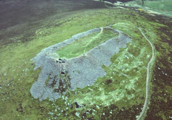
The site crowns the conspicuous 562 m high SW summit of the Hill of Noth. The major feature is the substantial remnant of the vitrified wall, defining an oblong approximately 100 m by 30 m in size. An internal depression, in which water may sometimes be seen, probably served as a cistern for the initial inhabitants. Although it is difficult to imagine such a high site being occupied on a permanent basis, there are slight traces of platforms, perhaps for circular wooden houses, on the S side beyond the collapsed rubble from the vitrified enclosure. Much further out, on the N and E, there is a much less impressive defence, formed by boulders strung out along the flanks of the hill.

This is one of the best examples of a vitrified fort, it is near the village of Rhynie in northeastern Scotland. This massive fort from prehistory is on the summit of a mountain of the same name which, being 1,859 feet (560 metres) high, commands an impressive view of the Aberdeenshire countryside. At first glance it seems that the walls are made of a rubble of stones, but on closer look it is apparent that they are made not of dry stones but of melted rocks! What were once individual stones are now black and cindery masses, fused together by heat that must have been so intense that molten rivers of rock once ran down the walls.

Dunnideer, Aberdeen

Dunnideer – Vitrified Fort

Grid ref: NJ 612 281 Ordnance Survey Landranger series sheet no. 37

12 miles NW of Inverurie. Access to the group of monuments on Dunnideer Hill is by a signposted footpath from minor road from Insch to Clashindarroch Forrest about 1 mile W of Insch , off the B 992.

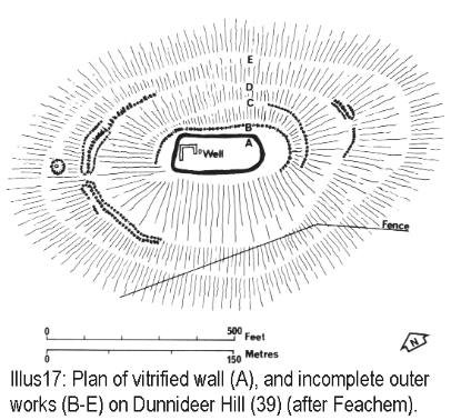
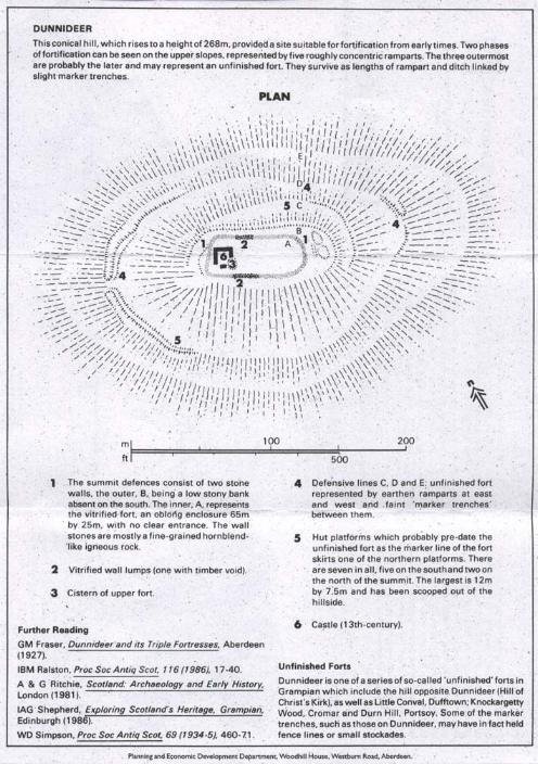
The Medieval Castle, the most prominent feature in the hill, stands inside, and is built from the debris of, an oblong vitrified fort, a maximum length approximately 70 m, which crowns the summit. Outworks, most clearly marked on the E, may be associated with this phase. Early features in the interior include a depression adjacent to the castle, which is probably the remains of a cistern or a well. A rectilinear building, set at right angles to the main axis of the vitrified fort, is certainly later in date. Further out and downslope, traces of slight banks and ditches can be noted: these represent an unfinished defensive scheme, almost certainly later in date than the vitrified fort. On both the N and S slopes, traces of what appear as small grass-covered quarry scoops, fronted by level platforms c 8 m in diameter, can be noted. These represent the stances for timber round-houses which may date from as early as 1200 BC.

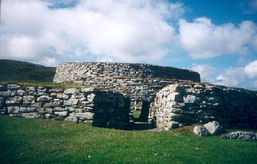
Clickhimin, Shetland

Clickhimin Broch

Location: 1 mile SW of Lerwick, Shetland.

Owner: Historic Scotland

This site was occupied in several periods, originally late Bronze age between 700 – 500BC. Firstly a simple farmstead which expanded to a blockhouse (fort) and then by a huge circular brock. A population of around 60 lived in this little fortress. Later, 2nd century occupation is shown when a wheelhouse was added.

The fort and broch at Clickhimin display a sequence of development
from the later Bronze Age to the later 1st millennium AD

“Shetland falls outside the range covered here, but the monogragh on Clickhimin is of primary importance, not only for the details of the excavation of the small fortress, but because it sets out a convincing hypothesis as to the nature and origins of the ‘vitrified’ forts of the Scottish mainland.” – AHA Hogg, Hill-forts of Britain.

Clickhimin, it appears is not a vitrified fort, the above reference was made in the light that it may be one of the oldest timber framed ramparts in Scotland. It has been suggested that all vitrified forts were timber framed.


Excavations at Clickhimin by J R C Hamilton.

Craig Phadrig, Inverness

Craig Phadrig – Vitrified Fort

Region : Scottish Highlands
District : Inverness
Town or village : Inverness
Grid Reference : NH 640 452
Period : 500 BC-AD 600

Craig Phadraig is a hilltop fort within a Forestry Commission plantation, 2.5km west of Inverness. It occupies a position with excelent views over the Beauly Firth. The rectangular area enclosed within the ramparts measures 75m x 23m. Radiocarbon dating indicates that the fort was built in 5th or 4th century BC.
The site comprises two steep ramparts, which are mainly grass grown. These were constructed of timberlaced stonework and then burnt, producing extensive vitrification. A vitrified part of the wall can be seen near a pine tree at the northern end.

The ramparts are grass covered, the inner stand 4m high externally and 1m internally, the ruined rasmparts spread some 10m in width. No entrances to the inner rampart have been found. The interior of the fort has an area of 0.2 hectares..

The outer rampart is much slighter, a mound in the eastern corner may be natural.

Excavation in 1971 has produced evidence of re-occupation in the time of the Picts, 6th century AD.

Inner rampart of Craig Phadrig

Research Notes

“The construction of the circling rampart at Craig Phadrig has been examined in detail and the basic principles there established probably apply to all forts within the Inverness area. The total thickness of the wall at Craig Phadrig was just under 21 feet (6 m.) and on the basis of the quantity of the collapsed debris still remaining, must have originally stood at least 26 feet (8 m.) high. The rampart consists of two revetments enclosing a rubble core. All stone was obtained locally if available, by surface collection, although for some forts (including Craig Phadrig?) quarrying must have been essential, particularly for suitable blocks for the revetment

The rampart was founded on the natural turf, no previous preparation having been undertaken except the marking out of the line of the wall. In some cases it is suggested that the rampart was founded on a raft of logs, but no examples of this type appear in this area. The revetting walls were carefully constructed, each occupying about one-third of the total width of the wall at the base, and gradually thinning as the structure reached its full height. The lowest yard (m.) is invariably constructed of very large blocks to provide an adequate foundation, while above this smaller blocks were used, and frequently timber lacing was introduced into the design. Clear evidence of horizontal timber beams running from the inner revetment into the core was found at Craig Phadrig, and circumstantial evidence supports a network of horizontal, transverse and vertical limbers tying the inner revetment thoroughly to the core. Although timber beams appear in the outer face of some continental forts, they never did so at Craig Phadrig. Besides its value in tying revetment to core, limber lacing has the advantage of preventing a large section of the core “running” should the outer revetment be breached by attackers. If that happened, a natural causeway would be provided for the invaders. Furthermore, timber lacing has the properly of spreading the weight-load in a massive structure. Brochs built entirely of dry stone, without any timber lacing, frequently show intensive shattering and cracking of stones in the lower courses due to the pressure from above.

Small finds and continental parallels were the original dating criteria for fixing these forts firmly within the Celtic Iron Age, and the use of radio-carbon dates on the Scottish forts in the last decade has confirmed the date for Craig Phadrig, to be 350 B.C.; Craig-marloch Wood. The evidence from several sites, including Craig Phadrig. Suggests that the primary fort survived for a relatively short time, and was refurbished later.

“A preliminary examination of the bones from Craig Phadrig shows a high proportion of red deer, and also possibly reindeer. The European wild boar is also recorded. Of the pastoral animals, cattle were by far the most important.” The Hill Forts of the Inverness Area, ALAN SMALL

Contact Us
close slider

    What is 9 + 4?